Kosciuszko-Nationalpark
| Kosciuszko National Park | |||
|---|---|---|---|
 | |||
| |||
| Lage: | New South Wales, Australien | ||
| Besonderheit: | Berglandschaft | ||
| Nächste Stadt: | Cabramurra – Canberra | ||
| Fläche: | 6.734,92 km² | ||
| Gründung: | 1944 | ||
| i2i3i6 | |||


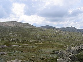
Der Kosciuszko-Nationalpark (engl. Kosciuszko National Park) ist ein 6734,92 km² großes Naturschutzgebiet im australischen Bundesstaat New South Wales, etwa 350 km südwestlich der Metropole Sydney.

Der Nationalpark befindet sich im Gebirgszug der Snowy Mountains und umgibt seinen Namensgeber, den Mount Kosciuszko, der mit 2228 m der höchste Berg des Kontinentes ist. Aufgrund der großen Höhe findet man im Park ein für Australien außergewöhnliches alpines Klima mit entsprechender Vegetation und die Landschaft zeigt Spuren einer früheren Vergletscherung. Ebenfalls im Park befindet sich Mount Townsend, der mit 2209 m zweithöchste Berg auf dem Festland des australischen Kontinents.
Der Nationalpark wurde im Juni 1944 gegründet[1] und ist der größte in New South Wales.
Einzelnachweise
- ↑ http://www.environment.nsw.gov.au/NationalParks/parkManagement.aspx?id=N0018
Weblinks
Commons: Kosciuszko-Nationalpark – Sammlung von Bildern und Videos
- Offizielle Website (engl.)

Nationalparks in New South Wales (Australien)
A Abercrombie River | Arakoon | Arakwal | B Bago Bluff | Bald Rock | Bangadilly | Barakee | Barool | Barrington Tops | Basket Swamp | Belford | Bellinger River | Benambra | Bendick | Ben Halls Gap | Beowa | Berowra | Bimberamala | Bindarri | Biriwal-Bulga | Blue Mountains | Bongil Bongil | Boonoo-Boonoo | Booti-Booti | Border Ranges | Botany Bay | Bouddi | Bournda | Brindabella | Brisbane Water | Broadwater | Budawang | Budderoo | Bugong | Bundjalung | Bungawalbin | Bungonia | Butterleaf | C Capoompeta | Carrai | Cascade | Cataract | Cathedral Rock | Cattai | Chaelundi | Clyde River | Cocoparra | Columbey | Conimbla | Conjola | Coolah Tops | Coorabakh | Cottan-Bimbang | Crowdy Bay | Culgoa | Cunnawarra | Curracabundi | D Dharawal | Deua | Dharug | Dooragan | Dorrigo | Dunggir | E Eurobodalla | F Fortis Creek | G Gaagal Wanggaan | Gardens of Stone | Garigal | Garrawilla | Georges River | Ghin Doo Ee | Gibraltar Range | Gir-um-bit | Gondwana-Regenwälder | Goobang | Goolawah | Goonengerry | Goulburn River | Gourock | Gulaga | Gumbaynggirr | Gundabooka | Guy Fawkes River | H Hat Head | Heathcote | Hunter Wetlands | I Indwarra | J Jerrawangala | Jervis Bay | Junuy Juluum | K Kalyarr | Kanangra-Boyd | Karuah | Kemendok | Keverstone | Kinchega | Kings Plains | Kooraban | Koreelah | Kosciuszko | Kumbatine | Ku-ring-gai-Chase | Kwiambal | L Lachlan Valley | Lane Cove | Livingstone | M Macquarie Pass | Mallanganee | Mallee Cliffs | Mares Forest | Maria | Marramarra | Marrangaroo | Maryland | Mebbin | Meroo | Middle-Brother | Mimosa Rocks | Minjary | Monga | Mooball | Morton | Mount Clunie | Mount Imlay | Mount Jerusalem | Mount Kaputar | Mount Nothofagus | Mount Pikapene | Mount Royal | Mount Warning | Mummel Gulf | Mungo | Murramarang | Murray Valley | Mutawintji | Myall Lakes | N Nangar | Nattai | New England | Nightcap | Nowendoc | Nymboi-Binderay | Nymboida | O Oolambeyan | Oxley-Wild-Rivers | P Paroo-Darling | Popran | R Ramornie | Richmond Range | Royal | S Saltwater | Scheyville | Scone Mountain | Seven Mile Beach | Single | South East Forest | Sturt | Sydney Harbour | T Tallaganda | Tapin Tops | Tarlo River | Thirlmere Lakes | Tilligerry | Timbarra | Tomaree | Tooloom | Toonumbar | Toorale | |Towarri | Turon | U Ulidarra | W Wadbilliga | Wallarah | Wallaroo | Wallingat | Warra | Warrabah | Warrumbungle | Washpool | Watagans | Weddin Mountains | Werakata | Werrikimbe | Willandra | Willi-Willi | Woko | Wollemi | Wollumbin | Woolooma | Woomargama | Worimi | Wyrrabalong | Y Yabbra | Yanga | Yanununbeyan | Yarriabini | Yarrahapinni Wetlands | Yengo | Yuraygir
Normdaten (Geografikum): VIAF: 315526959


