1918 Celebes Sea earthquake
Earthquake in the Philippines
5°58′01″N 124°22′37″E / 5.967°N 124.377°E / 5.967; 124.377[1]


Moro Gulf
1976
1918
2002
class=notpageimage|
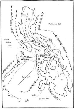
Near the Cotabato Trench, two of the largest 20th century Philippine earthquakes: the 1918 Celebes Sea earthquake (8.3 Mw) and the 1976 Moro Gulf earthquake (8.0 Mw). Also included is the recent 2002 Mindanao earthquake (7.5 Mw). The Moro Gulf, part of the Celebes Sea, is labeled for context.The 1918 Celebes Sea earthquake occurred on August 15 at 12:18 UTC near the Moro Gulf coast of Mindanao.[2] It had a magnitude of 8.3 on the moment magnitude scale[3] and a maximum perceived intensity of X (Extreme) on the Mercalli intensity scale. The earthquake has been associated with the Cotabato Trench, the surface expression of an active east-dipping subduction zone beneath Mindanao.[4]
Earthquake
The earthquake had a magnitude of 8.3 on the Moment magnitude scale, it had an estimated depth of 20 kilometers. The earthquake was 75 kilometers South southwest of Palimbang, Sultan Kudarat.[5] A station at Butuan registered over 600 aftershocks.[6]
Tsunami
This event in the southern Philippines triggered a large tsunami, with a maximum run-up of 7.2 m,[7] which affected the coasts of the Celebes Sea, causing widespread damage. The combined effects of the earthquake and the tsunami caused 52 casualties. With some sources stating that the tsunami alone caused up to 1,000 casualties.[8]
Losses
The estimated losses were up to 5-25 million dollars. There was damage to a stone bridge at Paleleh, Central Sulawesi.[6]
See also
- 1897 Mindanao earthquakes
- 1976 Moro Gulf earthquake
- List of earthquakes in 1918
- List of earthquakes in the Philippines
References
- ^ a b c "M 8.3 - Mindanao, Philippines". United States Geological Survey. August 15, 1918. Retrieved August 27, 2017.
- ^ "Comments for the Significant Earthquake". Significant Earthquake Database. National Geophysical Data Center. Retrieved June 27, 2015.
- ^ ISC (June 27, 2015), ISC-GEM Global Instrumental Earthquake Catalogue (1900–2009), Version 2.0, International Seismological Centre
- ^ Stewart, G.S.; Cohn, S.N. (1979). "The 1976 August 16, Mindanao , Philippine earthquake (Ms = 7.8) - evidence for a subduction zone south of Mindanao". Geophysical Journal of the Royal Astronomical Society. 57 (1): 51–65. Bibcode:1979GeoJ...57...51S. CiteSeerX 10.1.1.926.8672. doi:10.1111/j.1365-246X.1979.tb03771.x.
- ^ earthquake.usgs.gov https://earthquake.usgs.gov/earthquakes/eventpage/iscgem913230/executive#executive. Retrieved June 19, 2024.
{{cite web}}: Missing or empty|title=(help) - ^ a b "Major mag. 8.3 Earthquake - Celebes Sea, 143 km southwest of Koronadal, Philippines, on Thursday, Aug 15, 1918, at 12:18 pm (Universal Time time)". volcanodiscovery.com. Retrieved June 19, 2024.
- ^ "Comments for the Tsunami Event". NGDC/WDS Tsunami Event Database. National Geophysical Data Center. Retrieved June 27, 2015.
- ^ Andrew (December 11, 2022). "The Philippines vs The Pacific Ring of Fire". Naked Expat. Retrieved June 19, 2024.
External links
- The International Seismological Centre has a bibliography and/or authoritative data for this event.
- v
- t
- e
Earthquakes in the 1910s
- Taiwan (8.1, Apr 12) †
- Costa Rica (6.4, May 4) †‡
- Kebin (7.7, Jan 3) †‡
- Sarez (7.4, Feb 18) †
- Michoacán (7.6, June 7) †
- Kikai Island (8.1, June 15)
- Guerrero (7.6, Dec 16)
- Asmara (?.?, Feb 27)
- Sulawesi–Mindanao (7.9, Mar 14)
- Eshan (6.7, Dec 21) †‡
- Avezzano (6.7, Jan 13) †‡
- Imperial Valley (6.3, June 23)
- Asmara (5.8, Sept 23)
- Pleasant Valley (6.8, Oct 2)
- Bali (6.6, Jan 20) †‡
- San Salvador (6.7, Jun 7) †
- Samoa (8.5, Jun 25)
- Nantou (6.8, Aug 28) †
- Guatemala (5.6, Dec 25) †
- Shantou (7.2, Feb 13) †‡
- San Jacinto (6.7, April 21)
- Celebes Sea (8.3, Aug 15) †
- San Fermín (7.5, Oct 11) †
- Vancouver Island (7.2, Dec 6)
- Ayvalık (7.0, Nov 18) †‡
† indicates earthquake resulting in at least 30 deaths
‡ indicates the deadliest earthquake of the year
‡ indicates the deadliest earthquake of the year


