Abrahamsberg metro station
Stockholm Metro station
59°20′11″N 17°57′15″E / 59.3364°N 17.9542°E / 59.3364; 17.9542| Preceding station |  Stockholm metro Stockholm metro | Following station | ||
|---|---|---|---|---|
| Brommaplan towards Åkeshov | Line 17 | Stora mossen towards Skarpnäck | ||
| Brommaplan towards Hässelby strand | Line 19 | Stora mossen towards Hagsätra | ||
Location | |
|---|---|
 |
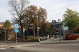
Abrahamsberg is a station on the Green line of the Stockholm metro. It is located on the border between the districts of Ulvsunda and Abrahamsberg, which are part of the borough of Bromma in the west of the city of Stockholm. The station is above ground and has a single island platform, with access from underpass carrying Abrahamsbergsvägen under the line.[2][3]
The station lies on the route of a line known as the Ängbybanan [sv] that formerly linked Alvik and Islandstorget. The Ängbybanan was designed and built for use by the future metro, but was operated from 1944 as part of line 11 of the Stockholm tramway. Abrahamsberg station was inaugurated as part of the metro on 26 October 1952 with the conversion of the Ängbybanan and its extension to form the metro line between Hötorget and Vällingby.[2][4]
As part of Art in the Stockholm metro project, this station features tiling in both the ticket hall and stairwell in a grey scale. A stoneware frieze in the ticket hall, created by Rigmor Roxner [sv] was installed in 1999.[5]
Gallery
-
 Station entrance, 2019
 -
 Station building, 2018
 -
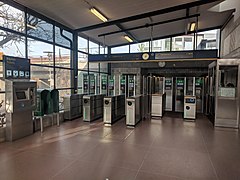 Ticket hall, 2018
 -
 Steps to platform, 2018


References
- ^ "Fakta om SL och regionen 2019" (PDF) (in Swedish). Storstockholms Lokaltrafik. p. 51. Archived (PDF) from the original on 27 December 2020. Retrieved 28 March 2021.
- ^ a b Schwandl, Robert. "Stockholm". urbanrail. Archived from the original on 23 April 2019. Retrieved 29 April 2019.
- ^ "Abrahamsberg T-bana". Google maps. Retrieved 9 March 2022.
- ^ Jacobson, Per (1998). En spårväg till Bromma [A tramway to Bromma] (in Swedish). Oslo: Baneforlaget. ISBN 82-91448-25-6.
- ^ "Art in the Stockholm metro" (PDF). Stockholm Transport. Archived from the original (PDF) on 13 September 2008. Retrieved September 10, 2008.
External links
- Images of Abrahamsberg
- v
- t
- e

| Shared stations | |
|---|---|
| 17 |
|
| 18 |
|
| 19 |
|


| Authority control databases: Geographic |
|
|---|
 | This article about a Swedish railway station is a stub. You can help Wikipedia by expanding it. |
- v
- t
- e
 | This Stockholm Metro article is a stub. You can help Wikipedia by expanding it. |
- v
- t
- e


