Agate Pass Bridge
Bridge in Suquamish, Washington
47°42′45″N 122°33′58″W / 47.7124°N 122.566°W / 47.7124; -122.566 SR 305
Agate Pass Bridge
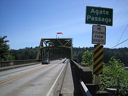

The Agate Pass Bridge is a structural steel truss cantilever bridge spanning Agate Pass, connecting Bainbridge Island to the Kitsap Peninsula. It was built in 1950, and it replaced a car ferry service which dated from the 1920s.[1] The bridge provides a direct route along Washington State Route 305 between Seattle, via the Seattle-Bainbridge Island ferry, and the Kitsap Peninsula.
The Agate Pass Bridge is 1,229 feet (375 m) long and is 75 feet (23 m) above the water and has a channel clearance of 300 feet (91 m) between piers.[2]
The original construction cost of $1,351,363 was paid out of the motor vehicle fund, and operated as a toll bridge from October 7, 1950, until October 1, 1951, when costs were repaid by a bond issue passed by the Washington State Legislature. The Washington Toll Bridge Authority managed the bridge during the year it took to repay the bond.[3]
The Agate Pass Bridge is listed on the National Register of Historic Places.
References
- ^ Kline, Mary; Bayless, George (1983). Ferryboats: legend on Puget Sound. Seattle: Bayless Books. p. 140. ISBN 0-914515-00-4.
- ^ Paula Becker. "Agate Pass Bridge connecting the north end of Bainbridge Island to mainland Kitsap County opens on October 7, 1950". THE FREE ENCYCLOPEDIA OF WASHINGTON STATE HISTORY. Retrieved December 18, 2017.
- ^ JOHN J. O'CONNELL, DOUGLAS HARTWICH. "HIGHWAYS ‑- IMPROPER EXPENDITURE OF HIGHWAY FUNDS". Washington State: Office of the Attorney General. Retrieved December 18, 2017.
- v
- t
- e
- List of U.S. National Historic Landmarks by state:
- Alabama
- Alaska
- Arizona
- Arkansas
- California
- Colorado
- Connecticut
- Delaware
- Florida
- Georgia
- Hawaii
- Idaho
- Illinois
- Indiana
- Iowa
- Kansas
- Kentucky
- Louisiana
- Maine
- Maryland
- Massachusetts
- Michigan
- Minnesota
- Mississippi
- Missouri
- Montana
- Nebraska
- Nevada
- New Hampshire
- New Jersey
- New Mexico
- New York
- North Carolina
- North Dakota
- Ohio
- Oklahoma
- Oregon
- Pennsylvania
- Rhode Island
- South Carolina
- South Dakota
- Tennessee
- Texas
- Utah
- Vermont
- Virginia
- Washington
- West Virginia
- Wisconsin
- Wyoming
 National Register of Historic Places portal
 Category


47°42′45″N 122°33′57″W / 47.71237°N 122.56591°W / 47.71237; -122.56591


