Arcoverde
Municipality in Northeast, Brazil
Flag

Coat of arms
Portal do Sertão
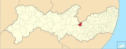
Location in Pernambuco state
(2022 [1])
Arcoverde is a municipality in Pernambuco, Brazil. It is located in the mesoregion of Sertão Pernambucano.[2] Arcoverde has a total area of 344 km²[3] and lies west of the capital Recife by 256 km. Arcoverde has boundaries with Paraíba to the north, Buíque and Pedra to the south, Pesqueira to the east, and Sertânia to the west.
In the census of 2022, Arcoverde had a population of 77,742 people,[4] making it the 22nd most populous municipality in Pernambuco and the third most populous in the Sertão Pernambucano region, trailing only Serra Talhada[5] and Araripina.[6]
Economy
The main economic activities in Arcoverde are based in general commerce, services and primary sector.
Climate
| Climate data for Arcoverde (1981–2010) | |||||||||||||
|---|---|---|---|---|---|---|---|---|---|---|---|---|---|
| Month | Jan | Feb | Mar | Apr | May | Jun | Jul | Aug | Sep | Oct | Nov | Dec | Year |
| Mean daily maximum °C (°F) | 31.4 (88.5) | 31.4 (88.5) | 30.7 (87.3) | 29.4 (84.9) | 27.9 (82.2) | 26.1 (79.0) | 25.4 (77.7) | 26.6 (79.9) | 29.0 (84.2) | 31.4 (88.5) | 32.3 (90.1) | 32.2 (90.0) | 29.5 (85.1) |
| Mean daily minimum °C (°F) | 19.5 (67.1) | 19.7 (67.5) | 19.6 (67.3) | 19.3 (66.7) | 18.7 (65.7) | 17.5 (63.5) | 16.8 (62.2) | 16.5 (61.7) | 17.1 (62.8) | 18.2 (64.8) | 18.9 (66.0) | 19.4 (66.9) | 18.4 (65.1) |
| Average precipitation mm (inches) | 67.9 (2.67) | 62.9 (2.48) | 111.6 (4.39) | 90.6 (3.57) | 78.2 (3.08) | 90.2 (3.55) | 79.7 (3.14) | 60.6 (2.39) | 19.3 (0.76) | 13.6 (0.54) | 16.0 (0.63) | 30.6 (1.20) | 721.2 (28.39) |
| Average precipitation days (≥ 1.0 mm) | 6 | 6 | 8 | 8 | 9 | 12 | 13 | 9 | 3 | 2 | 2 | 3 | 81 |
| Mean monthly sunshine hours | 224.9 | 209.9 | 229.9 | 223.8 | 210.6 | 175.5 | 184.6 | 229.5 | 260.6 | 291.7 | 278.7 | 266.2 | 2,785.9 |
| Source: Instituto Nacional de Meteorologia[7] | |||||||||||||
References
- ^ IBGE 2022
- ^ "BDE Mesorregiões".
- ^ "IBGE". cidades.ibge.gov.br. Retrieved 2024-02-24.
- ^ "População de Arcoverde (PE) é de 77.586 pessoas, aponta o Censo do IBGE". G1 (in Brazilian Portuguese). 2023-06-28. Retrieved 2024-02-24.
- ^ "Serra Talhada (PE) | Cidades e Estados | IBGE". www.ibge.gov.br. Retrieved 2024-02-24.
- ^ "Araripina (PE) | Cidades e Estados | IBGE". www.ibge.gov.br. Retrieved 2024-02-24.
- ^ "Normais Climatológicas Do Brasil 1981–2010" (in Portuguese). Instituto Nacional de Meteorologia. Retrieved 21 May 2024.
- v
- t
- e

Capital: Recife
Agreste Pernambucano
| Alto Capibaribe | |
|---|---|
| Brejo Pernambucano | |
| Garanhuns | |
| Médio Capibaribe | |
| Vale do Ipanema | |
| Vale do Ipojuca |

Mata Pernambucana
| Mata Meridional Pernambucana | |
|---|---|
| Mata Setentrional Pernambucana | |
| Vitoria de Santo Antão |
Metropolitana de Recife
| Itamaracá | |
|---|---|
| Recife | |
| Porto de Suape | |
| Fernando de Noronha |
Sao Francisco Pernambucano
| Itaparica | |
|---|---|
| Petrolina |
Sertão Pernambucano
| Araripina | |
|---|---|
| Pajeú | |
| Salgueiro | |
| Sertão do Moxotó |
Authority control databases | |
|---|---|
| International |
|
| National |
|
| Geographic |
|
 | This Pernambuco, Brazil location article is a stub. You can help Wikipedia by expanding it. |
- v
- t
- e


