Azalia, Michigan
Unincorporated community in Michigan, United States
42°01′08″N 83°39′57″W / 42.01889°N 83.66583°W / 42.01889; -83.6658348110
48131 (Dundee)
48159 (Maybee)
48131 (Dundee)
48159 (Maybee)
Azalia is an unincorporated community in Monroe County in the U.S. state of Michigan.[2] The community is located within Milan Township. As an unincorporated community, Azalia has no legally defined boundaries or population statistics of its own but does have its own post office with the 48110 ZIP Code.[3][4]
History
The community was first known as East Milan, or Reeves Station where a family named Reeves established the Star Bending Company. A post office opened on August 4, 1869[5][6] (or in 1866 by some accounts),[7] largely through the efforts of Daniel T. Hazen, to avoid having to travel to West Milan (now Cone) to pick up mail. Steven Frink was the first postmaster, followed by Hazen in 1867, Joseph Meadows in 1872, John M. Lewis in 1877, and A.C. Reynolds in 1884. On September 1, 1887, the postmaster-general issued orders changing the name of the post office from "East Milan" to "Azalia", which was the name of the railroad station and also named Meadows as postmaster again.[7]
The Toledo, Ann Arbor and Grand Trunk Railway (later the Toledo, Ann Arbor and North Michigan Railway and then the Ann Arbor Railroad), opened on June 8, 1878, with a station named "Azalia", named after one of the daughters of the president of the railroad, Azalia Ashley.[7]
A Methodist Episcopal Church began holding classes in the early 1850s, building a church in 1870, which continues to the present as the Azalia United Methodist Church.
Images
-
 Corner store and post office in 2010
 -
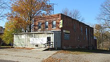 Closed market and post office in 2020
 -
 Azalia-United Methodist Church


References
- ^ "U.S. Census website". United States Census Bureau. Retrieved January 31, 2008.
- ^ a b U.S. Geological Survey Geographic Names Information System: Azalia, Michigan
- ^ UnitedStatesZipCodes.org (2021). "ZIP Code 48110: Azalia". Retrieved March 15, 2021.
- ^ Google (March 15, 2021). "48110 ZIP Code map" (Map). Google Maps. Google. Retrieved March 15, 2021.
- ^ U.S. Geological Survey Geographic Names Information System: Azalia Post Office
- ^ Romig, Walter (October 1, 1986) [1973]. Michigan Place Names: The History of the Founding and the Naming of More Than Five Thousand Past and Present Michigan Communities (Paperback). Great Lakes Books Series. Detroit, Michigan: Wayne State University Press. p. 38. ISBN 978-0-8143-1838-6.
- ^ a b c Milan Township History in History of Monroe County, Michigan, Wing, Talcott Enoch, ed. New York, Munsell & company, 1890. p. 593
- v
- t
- e
Municipalities and communities of Monroe County, Michigan, United States
County seat: Monroe

communities
- Avalon Beach
- Azalia
- Bolles Harbor
- Cone
- Diann
- Erie
- Evergreen Acres
- Exeter
- Golfcrest
- Grand View
- Grape
- Hillcrest Orchard
- Ida Center
- La Salle
- Liberty Corners
- London
- Lulu
- Newport
- North Shores
- Oakville
- Oldport
- Ottawa
- Ottawa Lake
- Patterson Gardens
- Petersburg Junction
- Pointe aux Peaux
- Rea
- Saint Anthony
- Samaria
- Scofield
- Steiner
- Stony Creek
- Strasburg
- Vienna
- Vienna Junction
- Whiteford Center
- Yargerville
‡This populated place also has portions in an adjacent county or counties
- Michigan portal
- United States portal
 | This Monroe County, Michigan location article is a stub. You can help Wikipedia by expanding it. |
- v
- t
- e


