Beaver Island Harbor Light
Lighthouse in Michigan, United States
Lighthouse
45°44′34″N 85°30′31″W / 45.74278°N 85.50861°W / 45.74278; -85.508611870 (current tower)
Beaver Island Light Station
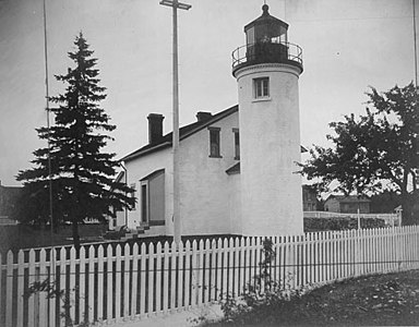
Beaver Island Harbor Light (or St. James Light) is a lighthouse located in St. James, Michigan, on the northern end of Beaver Island on Lake Michigan.[4] It has also been called "St. James Harbor Light" and "Whiskey Point Light". It is associated with a U.S. Coast Guard station, which was formerly a lifesaving station.[5] The tower is constructed of Cream City Brick.
Whiskey Point was originally named for the 1838 fur trading post that operated on the point, and for the commodity that was the post's chief item of sale. Soon afterward in the 1850s, St. James's Harbor on Beaver Island became established as a safe haven in a storm (an event quite common on Lake Michigan). The light was thus a natural extension of the emergency usage. The original light was constructed in 1856, and the light currently in use was constructed in 1870.[6]
At this time, the harbor is used by the Beaver Island ferry, so the light is still an active aid to navigation.
-
 U.S. Coast Guard Archive Photo
 -
 Station without Keeper's Quarters, U.S. Coast Guard Archive Photo


See also
References
- ^ Michigan Lighthouse Conservancy, St. James Harbor Light (Beaver Island)
- ^ Light List, Volume VII, Great Lakes (PDF). Light List. United States Coast Guard.
- ^ "National Register Information System". National Register of Historic Places. National Park Service. July 9, 2010.
- ^ U.S. Geological Survey Geographic Names Information System: Beaver Island Harbor Lighthouse. Retrieved on 2008-04-13.
- ^ History of the Beaver Island (Whiskey Point) Lights Archived 2008-10-10 at the Wayback Machine by the Beaver Beacon.
- ^ Terry Pepper. "Seeing the Light - Beaver Island Harbor Lighthouse". Archived from the original on 2 April 2008. Retrieved 2008-04-13.
External links
- Aerial photos, Beaver Harbor Lighthouse, marinas.com.
- Clarke Historical Library, Central Michigan University, Bibliography for Charlevoix County.
- History of the Beaver Island (Whiskey Point) Lights by the Beaver Beacon.
- v
- t
- e
- Au Sable
- Big Bay Point
- Copper Harbor
- Copper Harbor Front Range
- Crisp Point
- Eagle Harbor
- Eagle Harbor Range Lights
- Eagle River
- Fourteen Mile Point
- Grand Island East Channel
- Grand Island Harbor Rear Range
- Grand Island North
- Grand Marais Range Lights
- Granite Island
- Gull Rock
- Huron Island
- Isle Royale
- Manitou Island
- Marquette Breakwater Outer
- Marquette Harbor
- Mendota (Bete Grise)
- Munising Front Range
- Munising Rear Range
- Ontonagon
- Ontonagon Harbor West Breakwater
- Portage River (Jacobsville)
- Passage Island
- Presque Isle Harbor Breakwater Light
- Rock Harbor
- Rock of Ages
- Sand Hills
- Sand Point Light (Baraga)
- St. Martin Island
- Stannard Rock
- Thunder Bay Island
- Whitefish Point

- Frying Pan Island
- Pipe Island
- Point Iroquois
- Round Island Light (St. Mary's River)
- Six Mile Point Range Rear
- Winter Point Range Front
- Keweenaw Waterway Lower Entrance
- Keweenaw Waterway Upper Entrance
- Portage Lake
- Rouleau Point Range Front and Rear Lights
- Beaver Island Harbor
- Beaver Island Head
- Big Sable Point
- Cedar River
- Charlevoix
- Charlevoix South Pier
- Frankfort
- Frankfort South Range
- Grand Haven North Pierhead
- Grand Haven South Pierhead Entrance
- Grand Haven South Pierhead Inner
- Grand Traverse
- Grays Reef
- Holland Harbor
- Ile Aux Galets
- Little Sable Point
- Little Traverse
- Ludington
- Manistee Pierhead
- Manning Memorial
- Mission Point
- Mission Point (1933)
- Muskegon Breakwater
- Muskegon Pier
- North Manitou Shoal
- Pentwater North Pierhead
- Pentwater South Pierhead
- Point Betsie
- Portage Lake
- South Fox Island
- South Haven
- South Manitou Island
- St. Joseph North Pier Inner
- St. Joseph North Pier Outer
- Waugoshance
- White River
- White Shoal
- Alpena
- Caseville Harbor
- Charity Island
- Cheboygan Crib
- Cheboygan River Front Range
- Detroit River
- Fort Gratiot
- Forty Mile Point
- Fourteen Foot Shoal
- Gibraltar
- Gravelly Shoal
- Harbor Beach
- Lake St. Clair
- Mariners Memorial
- Middle Island
- Miller Memorial
- New Presque Isle
- Old Presque Isle
- Peche Island Rear Range
- Poe Reef
- Pointe aux Barques
- Port Austin
- Port Sanilac
- Saginaw Bay
- Saginaw River Rear Range
- Spectacle Reef
- St. Clair Flats Front and Rear Range Light
- Sturgeon Point
- Tawas Point
- Thunder Bay Island
- Tri-Centennial Light of Detroit
- William Livingstone Memorial
- Windmill Point
- Au Sable North Pierhead
- Belle Isle
- Clinton River
- Ecorse
- Ecorse Range Rear
- Gibraltar
- Grassy Island
- Grassy Island North Channel Range Lights
- Grassy Island South Channel Range Lights
- Grosse Ile North Channel Range Lights
- Grosse Ile South Channel Range Lights
- Harwood Point East Range Front
- Kalamazoo River
- Mama Juda
- Mama Juda Range Front
- Manistee Main
- Middle Lake George
- Monroe Pier
- New Buffalo
- North Manitou Island
- Saginaw Bay
- Sand Beach North Entrance East
- Squaw Point
- St. Mary's River Lower Range Front
- Vidal Shoals Channel Range Front and Rear Lights
- Windmill Point Range Front and Rear Lights
- Lightship Huron
- List of lifesaving stations in Michigan
- Wixom Lake, Musselman Island lighthouse
| |
|---|---|
| Topics | |
| Lists by state |
|
| Lists by insular areas | |
| Lists by associated state | |
| Other areas | |
| Related | |
| |


| Authority control databases: Geographic |
|
|---|


