Bouquet Reservoir
Reservoir in the Sierra Pelona of Los Angeles County, California, United States
34°34′55″N 118°22′48″W / 34.5819°N 118.3799°W / 34.5819; -118.3799Los Angeles Aqueduct
Bouquet Reservoir is an artificial lake in the Angeles National Forest of Los Angeles County, California about 15 miles (24 km) west from Palmdale.
At elevation of 2,993 feet (912 m) in the Sierra Pelona Mountains, the reservoir capacity is 36,500 acre⋅ft (45,000,000 m3) and is formed by Bouquet Canyon Dam on Bouquet Creek, which is a tributary of the Santa Clara River. The dam is constructed of earthfill and is 190 feet (58 m) tall, measured from the elevation of the original streambed.
The dam was built by the city of Los Angeles and was completed in 1934 (90 years ago) (1934) Official opening ceremonies were held at noon on March 28, 1934. The reservoir is part of the Los Angeles Aqueduct system, which is where it gets much of its water. Both are owned by the Los Angeles Department of Water and Power. The reservoir's drainage basin is only 13.6 square miles (35 km2) where the average annual rainfall is 14–20 inches (360–510 mm). Its purpose is to provide regulation of releases and to store water in case there is an interruption upstream.
See also
- List of lakes in California
- List of dams and reservoirs in California
- Castaic Lake
- Dry Canyon Reservoir
References
- U.S. Geological Survey Geographic Names Information System: Bouquet Reservoir
- Department of Water Resources (2009). "Station Meta Data: Bouquet Canyon Dam (BQC)". California Data Exchange Center. State of California. Retrieved 2009-10-11.
External links
- "Mono Basin Research" (PDF). (20.7 KiB)
- University of California, San Francisco
- "California Public Utilities Commission" (PDF). (197 KiB)
- v
- t
- e
Santa Clara River Watershed
- Castaic Creek
- Piru Creek
- San Francisquito Creek
- Sespe Creek
- Angeles National Forest
- Bouquet Reservoir
- California State Route 126
- Castaic Lake
- Castaic Lake State Recreation Area
- Dry Canyon Reservoir
- Elizabeth Lake
- Hughes Lake
- Lake Piru
- Los Angeles Aqueduct
- Los Padres National Forest
- McGrath State Beach
- Mentryville
- Mint Canyon Formation
- Munz Lakes
- Oxnard Plain
- Placerita Canyon State Park
- Pyramid Dam
- Pyramid Lake
- Rancho Camulos
- Rancho El Rio de Santa Clara o la Colonia
- Rancho San Francisco
- Rancho Santa Clara del Norte
- Rancho Santa Paula y Saticoy
- Rancho Sespe
- Santa Clara River Trail
- Santa Clara River Valley
- Santa Clarita Valley
- San Emigdio Mountains
- San Francisquito Canyon
- St. Francis Dam
- San Gabriel Mountains
- Santa Susana Mountains
- Saticoy Oil Field
- Sespe Wilderness
- Sierra Madre Mountains
- Sierra Pelona Ridge
- Six Flags Magic Mountain
- Soledad Canyon
- Topatopa Mountains
- Vasquez Rocks
Dams in Los Angeles County, California | ||
|---|---|---|
| CA Department of Water Resources | 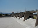 | |
| LA Department of Public Works |
| |
| LA Department of Water and Power |
| |
| US Army Corps of Engineers | ||
| Other |
| |


