Cà Mau province
Province of Vietnam
You can help expand this article with text translated from the corresponding article in Vietnamese. Click [show] for important translation instructions.
- Machine translation, like DeepL or Google Translate, is a useful starting point for translations, but translators must revise errors as necessary and confirm that the translation is accurate, rather than simply copy-pasting machine-translated text into the English Wikipedia.
- Do not translate text that appears unreliable or low-quality. If possible, verify the text with references provided in the foreign-language article.
- You must provide copyright attribution in the edit summary accompanying your translation by providing an interlanguage link to the source of your translation. A model attribution edit summary is
Content in this edit is translated from the existing Vietnamese Wikipedia article at [[:vi:Cà Mau]]; see its history for attribution. - You may also add the template
{{Translated|vi|Cà Mau}}to the talk page. - For more guidance, see Wikipedia:Translation.
Province in Mekong Delta, Vietnam
Cà Mau Province Tỉnh Cà Mau | |
|---|---|
Province | |
 Đá Bạc Islet in Cà Mau | |
 Seal | |
| Nickname: Dark water | |
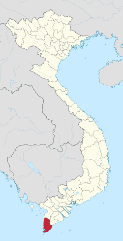 Location of Cà Mau within Vietnam | |
| Coordinates: 9°5′N 105°5′E / 9.083°N 105.083°E / 9.083; 105.083 | |
| Country |  Vietnam Vietnam |
| Region | Mekong Delta |
| Capital | Cà Mau |
| Government | |
| • People's Council Chair | Huỳnh Quốc Việt |
| • People's Committee Chair | Nguyễn Tiến Hải |
| Area | |
| • Total | 5,274.51 km2 (2,036.50 sq mi) |
| Population (2022)[2] | |
| • Total | 1,607,600 |
| • Density | 300/km2 (790/sq mi) |
| Demographics | |
| • Ethnicities | Vietnamese, Khmer, Hoa |
| GDP[3] | |
| • Total | VND 53.229 trillion US$ 2.312 billion |
| Time zone | UTC+7 (ICT) |
| Area codes | 290 |
| ISO 3166 code | VN-59 |
| Website | www |
Cà Mau (Vietnamese: [kaː˨˩ maw˧˧] ⓘ) is a province of Vietnam, named after its capital city. It is located in the Mekong Delta of southern Vietnam, and is the southernmost of Vietnam's 63 provinces. It is bordered to the north by Kiên Giang and Bạc Liêu provinces, to the west by the Gulf of Thailand, and to the south and east by the South China Sea.[4]
Economy
Being surrounded by water on three sides, fishing is an important industry in Cà Mau province. An extensive network of canals also supports a strong agricultural sector, as well as providing a popular means of transport. The U Minh biosphere reserve and Mũi Cà Mau, the southernmost point of Vietnam, serve also as important tourist destinations. The Mũi Cà Mau National Park is located at Mũi Cà Mau.
Administrative divisions

Cà Mau is subdivided into nine district-level sub-divisions:[5]
8 districts:
1 provincial city:
- Cà Mau (capital)
They are further subdivided into nine commune-level towns (or townlets), 82 communes, and 10 wards.
Typhoon Linda (1997)
In November 1997, the Cà Mau Peninsula was struck by Typhoon Linda (Openg). Thousands of people were killed, and an estimated 200,000 homes were destroyed, along with much of the Cà Mau fishing fleet.[6]
References
- ^ Biểu số 4.6: Hiện trạng sử dụng đất vùng Đồng Bằng Sông Cửu Long năm 2022 [Table 4.6: Current land use status in the Mekong Delta in 2022] (PDF) (Decision 3048/QĐ-BTNMT) (in Vietnamese). Ministry of Natural Resources and Environment (Vietnam). 18 October 2023. – the data in the report are in hectares, rounded to integers
- ^ General Statistics Office of Vietnam. "Population and Employment: Population and population density in 2006 by province". 7. Archived from the original on 2008-06-12. Retrieved 2008-05-31.
- ^ "Tình hình kinh tế, xã hội Cà Mau năm 2018". Cổng thông tin điện tử tỉnh Cà Mau. Retrieved 10 May 2020.
- ^ CA MAU PEOPLE'S COMMITTEE. "Introduction: Geographical Position". Archived from the original on 2009-01-20. Retrieved 2008-05-31.
- ^ CA MAU PEOPLE'S COMMITTEE. "Towns, Districts: Overview". Archived from the original on 2009-01-20. Retrieved 2008-05-31.
- ^ Dodd, Jan; et al. (2003). The Rough Guide to Vietnam. Rough Guides. ISBN 9781843530954. Retrieved 2008-06-02.
External links
- Official website
Places adjacent to Cà Mau province | |
|---|---|


- v
- t
- e
- Northeast
- Northwest
- Red River Delta
- North Central Coast
- South Central Coast
- Central Highlands
- Southeast
- Mekong Delta
- An Giang
- Bà Rịa–Vũng Tàu
- Bắc Giang
- Bắc Kạn
- Bạc Liêu
- Bắc Ninh
- Bến Tre
- Bình Định
- Bình Dương
- Bình Phước
- Bình Thuận
- Cà Mau
- Cao Bằng
- Đắk Lắk
- Đắk Nông
- Điện Biên
- Đồng Nai
- Đồng Tháp
- Gia Lai
- Hà Giang
- Hà Nam
- Hà Tĩnh
- Hải Dương
- Hậu Giang
- Hòa Bình
- Hưng Yên
- Khánh Hòa
- Kiên Giang
- Kon Tum
- Lai Châu
- Lâm Đồng
- Lạng Sơn
- Lào Cai
- Long An
- Nam Định
- Nghệ An
- Ninh Bình
- Ninh Thuận
- Phú Thọ
- Phú Yên
- Quảng Bình
- Quảng Nam
- Quảng Ngãi
- Quảng Ninh
- Quảng Trị
- Sóc Trăng
- Sơn La
- Tây Ninh
- Thái Bình
- Thái Nguyên
- Thanh Hóa
- Thừa Thiên Huế
- Tiền Giang
- Trà Vinh
- Tuyên Quang
- Vĩnh Long
- Vĩnh Phúc
- Yên Bái
- District level subdivisions
- Commune level subdivisions
- List of cities
Authority control databases | |
|---|---|
| International |
|
| National |
|
| Geographic |
|


