Camelback Mountain
Landform in Maricopa County, Arizona


Camelback Mountain
Camelback Mountain (O'odham: Cew S-wegiom) is a mountain in Phoenix, Arizona, United States. The English name is derived from its shape, which resembles the hump and head of a kneeling camel.[3] The mountain, a prominent landmark of the Phoenix metropolitan area, is located in the Camelback Mountain Echo Canyon Recreation Area between the Arcadia neighborhood of Phoenix and the town of Paradise Valley. It is a popular recreation destination for hiking and rock climbing.
History
A cave discovered on the north side of Camelback Mountain indicates that it was used as a sacred site by the prehistoric Hohokam culture before they abandoned the area in the 14th century.[4]
In January 1879, United States President Rutherford B. Hayes included Camelback Mountain as part of a one million acre (4,000 km2) reservation for the Salt River Pima and Maricopa American Indian tribes.[5] Six months later, at the behest of Charles Poston, the Arizona Territorial Legislature reversed the decision in order to ensure the primacy of the 5000 non-Indian area residents as well as their continued access to Salt River water.[6]
Efforts to protect Camelback Mountain as a natural preserve began in the early 1910s. However, by the 1960s, nearly all of the area had been sold to private interests. Federal and state authorities attempted to stop development above the one thousand and six hundred feet level. They failed to halt development and in 1963 efforts to arrange a land exchange failed in the Arizona State legislature. In 1965, United States Senator Barry Goldwater took up the cause and helped to secure the higher elevations against development. The area became a Phoenix city park in 1968.[7]
The peak lends its name to a major east-west street in the Phoenix area called Camelback Road that starts in Scottsdale and goes about 34 miles (55 km) west past the West Valley suburbs of Goodyear and Litchfield Park. It starts again past the White Tanks.
Camelback Mountain is designated as a Phoenix Point of Pride.[8]
Geology
The mountain is composed of a geologic unconformity between two separate rock formations. The higher part of the peak is Precambrian granite (ca. 1.5 billion years old). The head of the camel is predominantly red sedimentary sandstone from the Chattian stage of the Oligocene epoch (ca. 25 million years old).[9]
Recreation
Two hiking trails ascend 1,280 feet (390 m) to the peak of Camelback Mountain. The Echo Canyon Trail is 1.14 miles (1900 m) and the Cholla Trail is 1.4 mi (2300 m). Both trails are considered strenuous with steep grades. The hiking path has dirt, gravel, boulders, and some handrail-assisted sections. The average hike requires a round trip time of 1.5 to 3 hours.[10]
The Praying Monk is a red sandstone rock formation which is used for rock climbing. Located on the northern slope, the formation resembles the silhouette of a person kneeling in prayer.[11] It rises approximately 100 feet (30 m) and the eastern face has several permanent anchor bolts for attaching a belay rope.[12]
Gallery
-
 Aerial view
 -
 Camelback summit, viewed from red sandstone formation to the northwest
 -
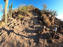 Cholla Trail.
 -
 Summit, viewed from Cholla Trail to the southeast.
 -
 Cave on north side of mountain.
 -
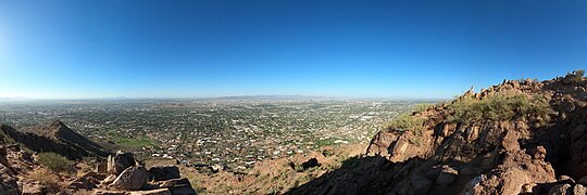 Panorama, just below the summit, at right.
 -
 Echo Canyon Trail.
 -
 Red sandstone formation just off Echo Canyon Trail.
 -
 View from south end of summit showing formations as well as distant Piestewa Peak (background, center).


See also
 Arizona portal
 Geography portal


References
- ^ a b "Camels Back 2". NGS Data Sheet. National Geodetic Survey, National Oceanic and Atmospheric Administration, United States Department of Commerce. Retrieved 2008-11-25.
- ^ "Camelback Mountain, Arizona". Peakbagger.com. Retrieved 2008-11-25.
- ^ Driggs, Gary (2008). Camelback Mountain. Arcadia Publishing. p. 9. ISBN 978-0-7385-4840-1.
- ^ (Driggs 2008, p. 23)
- ^ (Driggs 2008, p. 27)
- ^ (Driggs 2008, p. 27)
- ^ Lindstrom, Matthew J.; Bartling, Hugh (2003). "8: "The Straw that Broke the Camel's Back"". Suburban sprawl: culture, theory, and politics. Rowman & Littlefield.
- ^ "Phoenix Points of Pride". City Attractions. City of Phoenix. 2014. Archived from the original on 2014-02-19. Retrieved 2014-02-01.
- ^ (Driggs 2008, p. 9)
- ^ Liu, Charles (2006). 60 hikes within 60 miles. Phoenix: Menasha Ridge Press. p. 10. ISBN 9780897325936.
- ^ (Driggs 2008, p. 20)
- ^ Driggs, Gary (July 1998). Camelback: Sacred Mountain of Phoenix. Arizona Historical Foundation. pp. 146–156. ISBN 0-910152-17-9.
External links
Wikimedia Commons has media related to Camelback Mountain.
- Camelback Mountain. City of Phoenix official website.
- Camelback Mountain hiking information. ClimbCamelback.com.
- Echo Canyon trail description, GPS track, photos, trip logs and more. HikeArizona.com.
- Cholla trail description, GPS track, photos, trip logs and more. HikeArizona.com.
- Trailhead information, directions, photos, tips, history, wildlife and more. HikeCamelback.com.
- v
- t
- e
(Yavapai County)
- Boundary Cone
- Fortification Hill
- Mount Wilson
- Mount Union
- Castle Dome
- Carr Peak
- Miller Peak
- Aubrey Peak
- Hualapai Peak
- Lime Peak
- Mae West Peaks
- Four Peaks
- Mount Ord
- East End
- McDowell Peak
- Mount McDowell
- Thompson Peak
- Mount Ballard (Arizona)
- Camelback Mountain
- Mummy Mountain
- Piestewa Peak
- South Mountains
- Sunnyslope Mountain
- Ibex Peak
- Agassiz Peak
- Doyle Peak
- Fremont Peak
- Mount Bigelow
- Mount Lemmon
- Pusch Ridge
- Thimble Peak
- Mount Hopkins
- Mount Wrightson
- Mount Turnbull
- Mistake Peak
- Granite Mountain
- Black Dome
- Sentinel Peak
- Tumamoc Hill
- Apache Peak
- Black Mesa (Navajo County)
- Escudilla Mountain
- Mount Baldy
- Agathla Peak
- Agua Caliente Mountains
- Agua Dulce Mountains
- Antelope Hill
- Aquarius Mountains
- Artillery Mountains
- Atascosa Mountains
- Aubrey Hills
- Baboquivari Peak
- Balakai Mesa
- Beaver Dam Mountains
- Belmont Mountains
- Bill Williams Mountain
- Bitsihuitsos Butte
- Black Hills (Greenlee County)
- Black Mesa (Apache-Navajo Counties)
- Black Mesa (Warm Springs)
- Black Mountain (Maricopa County)
- Black Mountain (Pima County)
- Blackjack Mountains
- Bryan Mountains
- Buckskin Mountain (Arizona-Utah)
- Buckskin Mountains (La Paz County)
- Bush Head
- Cabeza Prieta Mountains
- Canelo Hills
- Carrizo Mountains
- Cerro Colorado Mountains
- Chocolate Mountains
- Copper Mountains
- Coyote Mountains
- Date Creek Mountains
- Dome Rock Mountains
- Dos Cabezas Mountains
- Etoi Ki
- Excalibur
- Galiuro Mountains
- Gavilan Peak
- Gila Bend Mountains
- Gila Mountains (Graham County)
- Gila Mountains (Yuma County)
- Goldfield Mountains
- Grand Wash Cliffs
- Granite Mountains
- Granite Wash Mountains
- Growler Mountains
- Gu Achi Peak
- Guadalupe Mountains
- Harcuvar Mountains
- Harquahala Mountains
- House Mountain
- Hunts Mesa
- Isis Temple
- John the Baptist Mountains
- Juniper Mesa
- Kaibab Plateau
- Kofa Mountains
- Laguna Mountains
- Las Guijas Mountains
- Lime Mountain (Maricopa County}
- Little Harquahala Mountains
- Little Rincon Mountains
- Lukachukai Mountains
- Madrean Sky Islands
- Mescal Mountains
- Mineral Mountains
- Moccasin Mountains
- Mohave Mountains
- Mohawk Mountains
- Mount Trumbull
- Muggins Mountains
- Mustang Mountains
- Navajo Mountain
- The Needles
- New River Mountains
- New Water Mountains
- Newton Butte
- Painted Rock Mountains
- Pajarito Mountains
- Patagonia Mountains
- Peacock Mountains
- Picacho Peak
- Picketpost Mountain
- Pinnacle Peak
- Poachie Range
- Poston Butte
- Rawhide Mountains
- Sacaton Mountains
- San Luis Mountains
- Santa Maria Mountains
- Sevenmile Mountains
- Sierra San Antonio
- Sierra Estrella
- Sierra Madre Occidental
- Sierra Pinta
- Silver Bell Mountains
- Squaw Tits
- Sugarloaf Mountain
- Sunset Mountains
- Swisshelm Mountains
- Tempe Butte
- Temple Butte
- Tinajas Altas Mountains
- Tordillo Mountain
- Tortolita Mountains
- Trigo Mountains
- Tule Mountains
- Tumacacori Mountains
- Virgin Mountains
- Vulcan's Throne
- Vulture Mountains
- Waterman Mountains
- Weaver Mountains
- West Silver Bell Mountains
- White Tank Mountains
- Wickenburg Mountains
Authority control databases | |
|---|---|
| International |
|
| National |
|


