Charleval, Eure
Commune in Normandy, France

Coat of arms
Location of Charleval

(2020–2026) Pascal Calais[1]
1
(2021)[2]
27151 /27380
(avg. 47 m or 154 ft)
Charleval (French pronunciation: [ʃaʁləval]) is a commune in the Eure department in northern France.
History
Formerly known as Noyon-sur-Andelle, it was renamed Charleval in honour of King Charles IX.
The Château de Charleval (begun 1570, unfinished, disappeared) was designed by Jacques I Androuet du Cerceau, who engraved his designs and published them in 1579.[3]
Château de Charleval
-
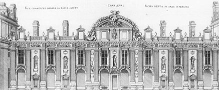 Court facade
 -
 General plan


Population
| Year | Pop. | ±% p.a. |
|---|---|---|
| 1968 | 1,636 | — |
| 1975 | 1,654 | +0.16% |
| 1982 | 1,753 | +0.83% |
| 1990 | 1,768 | +0.11% |
| 1999 | 1,872 | +0.64% |
| 2009 | 1,841 | −0.17% |
| 2014 | 1,833 | −0.09% |
| 2020 | 1,706 | −1.19% |
| Source: INSEE[4] | ||
See also
References
- ^ "Répertoire national des élus: les maires" (in French). data.gouv.fr, Plateforme ouverte des données publiques françaises. 13 September 2022.
- ^ "Populations légales 2021" (in French). The National Institute of Statistics and Economic Studies. 28 December 2023.
- ^ Jacques I Androuet du Cerceau, Le second volume des plus excellents Bastiments de France (Paris, 1579; reduced size reprint: Gregg International, 1972, ISBN 9780576154086). See also Commons:Category:Château de Charleval.
- ^ Population en historique depuis 1968, INSEE
Wikimedia Commons has media related to Charleval (Eure).
- v
- t
- e
Communes of the Eure department 

- Aclou
- Acon
- Acquigny
- Aigleville
- Ailly
- Aizier
- Alizay
- Ambenay
- Amécourt
- Amfreville-les-Champs
- Amfreville-Saint-Amand
- Amfreville-sous-les-Monts
- Amfreville-sur-Iton
- Andé
- Les Andelyssubpr
- Angerville-la-Campagne
- Appeville-Annebault
- Armentières-sur-Avre
- Arnières-sur-Iton
- Asnières
- Aulnay-sur-Iton
- Autheuil-Authouillet
- Authevernes
- Les Authieux
- Authou
- Aviron
- Bacquepuis
- Bacqueville
- Bailleul-la-Vallée
- Bâlines
- Barc
- Les Barils
- Barneville-sur-Seine
- La Baronnie
- Barquet
- Barville
- Les Baux-de-Breteuil
- Les Baux-Sainte-Croix
- Bazincourt-sur-Epte
- Bazoques
- Beaubray
- Beauficel-en-Lyons
- Beaumontel
- Beaumont-le-Roger
- Le Bec-Hellouin
- Le Bec-Thomas
- Bémécourt
- Bérengeville-la-Campagne
- Bernaysubpr
- Bernienville
- Bernouville
- Berthouville
- Berville-la-Campagne
- Berville-sur-Mer
- Beuzeville
- Bézu-la-Forêt
- Bézu-Saint-Éloi
- Bois-Anzeray
- Bois-Arnault
- Le Bois-Hellain
- Bois-Jérôme-Saint-Ouen
- Bois-le-Roi
- Boisney
- Bois-Normand-près-Lyre
- Boisset-les-Prévanches
- Boissey-le-Châtel
- La Boissière
- Boissy-Lamberville
- Boncourt
- Bonneville-Aptot
- La Bonneville-sur-Iton
- Le Bosc-du-Theil
- Bosgouet
- Bosquentin
- Bosrobert
- Bosroumois
- Les Bottereaux
- Bouafles
- Bouchevilliers
- Le Boulay-Morin
- Boulleville
- Bouquelon
- Bouquetot
- Bourg-Achard
- Bourg-Beaudouin
- Bournainville-Faverolles
- Bourneville-Sainte-Croix
- Bourth
- Bray
- Brestot
- Bretagnolles
- Breteuil
- Brétigny
- Breuilpont
- Breux-sur-Avre
- Brionne
- Broglie
- Brosville
- Bueil
- Burey
- Caillouet-Orgeville
- Cailly-sur-Eure
- Calleville
- Campigny
- Canappeville
- Caorches-Saint-Nicolas
- Capelle-les-Grands
- Caugé
- Caumont
- Cauverville-en-Roumois
- Cesseville
- Chaignes
- Chaise-Dieu-du-Theil
- Chamblac
- Chambois
- Chambord
- Chambray
- Champ-Dolent
- Champenard
- Champigny-la-Futelaye
- La Chapelle-Bayvel
- La Chapelle-du-Bois-des-Faulx
- La Chapelle-Gauthier
- La Chapelle-Hareng
- La Chapelle-Longueville
- Charleval
- Château-sur-Epte
- Chauvincourt-Provemont
- Chavigny-Bailleul
- Chennebrun
- Chéronvilliers
- Cierrey
- Claville
- Clef Vallée d'Eure
- Collandres-Quincarnon
- Colletot
- Combon
- Conches-en-Ouche
- Condé-sur-Risle
- Connelles
- Conteville
- Cormeilles
- Le Cormier
- Corneville-la-Fouquetière
- Corneville-sur-Risle
- Coudray
- Coudres
- Courbépine
- Courcelles-sur-Seine
- Courdemanche
- Courteilles
- La Couture-Boussey
- Crasville
- Crestot
- Criquebeuf-la-Campagne
- Criquebeuf-sur-Seine
- La Croisille
- Croisy-sur-Eure
- Crosville-la-Vieille
- Croth
- Cuverville
- Les Damps
- Dangu
- Dardez
- Daubeuf-la-Campagne
- Daubeuf-près-Vatteville
- Douains
- Doudeauville-en-Vexin
- Douville-sur-Andelle
- Droisy
- Drucourt
- Duranville
- Écaquelon
- Écardenville-la-Campagne
- Écauville
- Écouis
- Ecquetot
- Émalleville
- Émanville
- Épaignes
- Épégard
- Épieds
- Épreville-en-Lieuvin
- Épreville-près-le-Neubourg
- Étrépagny
- Étréville
- Éturqueraye
- Évreuxpref
- Ézy-sur-Eure
- Fains
- Farceaux
- Fatouville-Grestain
- Fauville
- Faverolles-la-Campagne
- Le Favril
- Ferrières-Haut-Clocher
- Ferrières-Saint-Hilaire
- La Ferrière-sur-Risle
- Feuguerolles
- Le Fidelaire
- Fiquefleur-Équainville
- Flancourt-Crescy-en-Roumois
- Fleury-la-Forêt
- Fleury-sur-Andelle
- Flipou
- Folleville
- Fontaine-Bellenger
- Fontaine-l'Abbé
- Fontaine-la-Louvet
- Fontaine-sous-Jouy
- La Forêt-du-Parc
- Fort-Moville
- Foucrainville
- Foulbec
- Fouqueville
- Franqueville
- Frenelles-en-Vexin
- Freneuse-sur-Risle
- Fresne-Cauverville
- Fresney
- Gadencourt
- Gaillon
- Gamaches-en-Vexin
- Garennes-sur-Eure
- Gasny
- Gauciel
- Gaudreville-la-Rivière
- Gauville-la-Campagne
- Gisors
- Giverny
- Giverville
- Glisolles
- Glos-sur-Risle
- La Goulafrière
- Goupil-Othon
- Gournay-le-Guérin
- Grand Bourgtheroulde
- Grand-Camp
- Graveron-Sémerville
- Gravigny
- Grosley-sur-Risle
- Grossœuvre
- Guerny
- Guichainville
- Guiseniers
- L'Habit
- Hacqueville
- Harcourt
- Hardencourt-Cocherel
- La Harengère
- Harquency
- Hauville
- La Haye-Aubrée
- La Haye-de-Calleville
- La Haye-de-Routot
- La Haye-du-Theil
- La Haye-le-Comte
- La Haye-Malherbe
- La Haye-Saint-Sylvestre
- Hébécourt
- Hecmanville
- Hécourt
- Hectomare
- Hennezis
- Herqueville
- Heubécourt-Haricourt
- Heudebouville
- Heudicourt
- Heudreville-en-Lieuvin
- Heudreville-sur-Eure
- La Heunière
- Heuqueville
- Les Hogues
- Hondouville
- Honguemare-Guenouville
- L'Hosmes
- Houetteville
- Houlbec-Cocherel
- La Houssaye
- Houville-en-Vexin
- Huest
- Igoville
- Illeville-sur-Montfort
- Illiers-l'Évêque
- Incarville
- Irreville
- Iville
- Ivry-la-Bataille
- Jouy-sur-Eure
- Juignettes
- Jumelles
- La Lande-Saint-Léger
- Le Landin
- Launay
- Léry
- Le Lesme
- Letteguives
- Lieurey
- Lignerolles
- Lilly
- Lisors
- Livet-sur-Authou
- Longchamps
- Lorleau
- Louversey
- Louviers
- Louye
- Lyons-la-Forêt
- La Madeleine-de-Nonancourt
- Mainneville
- Malleville-sur-le-Bec
- Malouy
- Mandeville
- Mandres
- Manneville-la-Raoult
- Manneville-sur-Risle
- Le Manoir
- Marais-Vernier
- Marbeuf
- Marbois
- Marcilly-la-Campagne
- Marcilly-sur-Eure
- Martagny
- Martainville
- Martot
- Mélicourt
- Ménesqueville
- Ménilles
- Menneval
- Mercey
- Merey
- Mesnil-en-Ouche
- Le Mesnil-Fuguet
- Le Mesnil-Jourdain
- Mesnil-Rousset
- Le Mesnil-Saint-Jean
- Mesnil-sous-Vienne
- Mesnils-sur-Iton
- Mesnil-sur-l'Estrée
- Mesnil-Verclives
- Mézières-en-Vexin
- Miserey
- Moisville
- Montfort-sur-Risle
- Montreuil-l'Argillé
- Les Monts du Roumois
- Morainville-Jouveaux
- Morgny
- Morsan
- Mouettes
- Mouflaines
- Mousseaux-Neuville
- Muids
- Muzy
- Nagel-Séez-Mesnil
- Nassandres sur Risle
- Neaufles-Auvergny
- Neaufles-Saint-Martin
- Le Neubourg
- Neuilly
- La Neuve-Grange
- La Neuve-Lyre
- La Neuville-du-Bosc
- Neuville-sur-Authou
- Noards
- La Noë-Poulain
- Nogent-le-Sec
- Nojeon-en-Vexin
- Nonancourt
- Normanville
- Notre-Dame-de-l'Isle
- Notre-Dame-d'Épine
- Notre-Dame-du-Hamel
- Le Noyer-en-Ouche
- Noyers
- Ormes
- Pacy-sur-Eure
- Parville
- Le Perrey
- Perriers-sur-Andelle
- Perruel
- Piencourt
- Pinterville
- Piseux
- Pîtres
- Les Places
- Plainville
- Le Planquay
- Plasnes
- Le Plessis-Grohan
- Le Plessis-Hébert
- Le Plessis-Sainte-Opportune
- Pont-Audemer
- Pont-Authou
- Pont-de-l'Arche
- Pont-Saint-Pierre
- Porte-de-Seine
- Portes
- Port-Mort
- Poses
- La Poterie-Mathieu
- Les Préaux
- Pressagny-l'Orgueilleux
- Prey
- Puchay
- Pullay
- La Pyle
- Quatremare
- Quillebeuf-sur-Seine
- Quittebeuf
- Radepont
- Renneville
- Reuilly
- Richeville
- Romilly-la-Puthenaye
- Romilly-sur-Andelle
- La Roquette
- Rosay-sur-Lieure
- Rougemontiers
- Rouge-Perriers
- Routot
- Rouvray
- Rugles
- Sacquenville
- Saint-Agnan-de-Cernières
- Saint-André-de-l'Eure
- Saint-Antonin-de-Sommaire
- Saint-Aubin-d'Écrosville
- Saint-Aubin-de-Scellon
- Saint-Aubin-du-Thenney
- Saint-Aubin-sur-Gaillon
- Saint-Aubin-sur-Quillebeuf
- Saint-Benoît-des-Ombres
- Saint-Christophe-sur-Avre
- Saint-Christophe-sur-Condé
- Saint-Cyr-de-Salerne
- Saint-Cyr-la-Campagne
- Saint-Denis-d'Augerons
- Saint-Denis-des-Monts
- Saint-Denis-le-Ferment
- Saint-Didier-des-Bois
- Sainte-Colombe-la-Commanderie
- Sainte-Colombe-près-Vernon
- Sainte-Geneviève-lès-Gasny
- Saint-Élier
- Saint-Éloi-de-Fourques
- Sainte-Marie-d'Attez
- Sainte-Marie-de-Vatimesnil
- Sainte-Marthe
- Sainte-Opportune-du-Bosc
- Sainte-Opportune-la-Mare
- Saint-Étienne-du-Vauvray
- Saint-Étienne-l'Allier
- Saint-Étienne-sous-Bailleul
- Saint-Georges-du-Vièvre
- Saint-Georges-Motel
- Saint-Germain-de-Fresney
- Saint-Germain-de-Pasquier
- Saint-Germain-des-Angles
- Saint-Germain-la-Campagne
- Saint-Germain-sur-Avre
- Saint-Grégoire-du-Vièvre
- Saint-Jean-du-Thenney
- Saint-Julien-de-la-Liègue
- Saint-Laurent-des-Bois
- Saint-Laurent-du-Tencement
- Saint-Léger-de-Rôtes
- Saint-Léger-du-Gennetey
- Saint-Luc
- Saint-Maclou
- Saint-Marcel
- Saint-Mards-de-Blacarville
- Saint-Mards-de-Fresne
- Saint-Martin-du-Tilleul
- Saint-Martin-la-Campagne
- Saint-Martin-Saint-Firmin
- Saint-Meslin-du-Bosc
- Saint-Ouen-de-Pontcheuil
- Saint-Ouen-de-Thouberville
- Saint-Ouen-du-Tilleul
- Saint-Paul-de-Fourques
- Saint-Philbert-sur-Boissey
- Saint-Philbert-sur-Risle
- Saint-Pierre-de-Bailleul
- Saint-Pierre-de-Cernières
- Saint-Pierre-de-Cormeilles
- Saint-Pierre-de-Salerne
- Saint-Pierre-des-Fleurs
- Saint-Pierre-des-Ifs
- Saint-Pierre-du-Bosguérard
- Saint-Pierre-du-Val
- Saint-Pierre-du-Vauvray
- Saint-Pierre-la-Garenne
- Saint-Samson-de-la-Roque
- Saint-Sébastien-de-Morsent
- Saint-Siméon
- Saint-Sulpice-de-Grimbouville
- Saint-Sylvestre-de-Cormeilles
- Saint-Symphorien
- Saint-Victor-de-Chrétienville
- Saint-Victor-d'Épine
- Saint-Victor-sur-Avre
- Saint-Vigor
- Saint-Vincent-des-Bois
- Saint-Vincent-du-Boulay
- Sancourt
- Sassey
- La Saussaye
- Saussay-la-Campagne
- Sébécourt
- Selles
- Serez
- Serquigny
- Surtauville
- Surville
- Suzay
- Sylvains-les-Moulins
- Terres de Bord
- Le Theil-Nolent
- Thénouville
- Thiberville
- Thibouville
- Thierville
- Le Thil
- Les Thilliers-en-Vexin
- Le Thuit
- Le Thuit-de-l'Oison
- Tilleul-Dame-Agnès
- Le Tilleul-Lambert
- Tillières-sur-Avre
- Tilly
- Tocqueville
- Le Torpt
- Touffreville
- Tournedos-Bois-Hubert
- Tourneville
- Tourville-la-Campagne
- Tourville-sur-Pont-Audemer
- Toutainville
- Treis-Sants-en-Ouche
- Le Tremblay-Omonville
- La Trinité
- La Trinité-de-Réville
- La Trinité-de-Thouberville
- Triqueville
- Les Trois Lacs
- Le Troncq
- Le Tronquay
- Trouville-la-Haule
- La Vacherie
- Valailles
- Le Val-David
- Val-de-Reuil
- Le Val-d'Hazey
- Le Val-Doré
- Val d'Orger
- Valletot
- Vandrimare
- Vannecrocq
- Vascœuil
- Vatteville
- Le Vaudreuil
- Vaux-sur-Eure
- Venon
- Les Ventes
- Verneuil d'Avre et d'Iton
- Verneusses
- Vernon
- Vesly
- Vexin-sur-Epte
- Vézillon
- Le Vieil-Évreux
- La Vieille-Lyre
- Vieux-Port
- Villegats
- Villers-en-Vexin
- Villers-sur-le-Roule
- Villettes
- Villez-sous-Bailleul
- Villez-sur-le-Neubourg
- Villiers-en-Désœuvre
- Vironvay
- Vitot
- Voiscreville
- Vraiville
- pref: prefecture
- subpr: subprefecture
Authority control databases | |
|---|---|
| International |
|
| National |
|
 | This Eure geographical article is a stub. You can help Wikipedia by expanding it. |
- v
- t
- e


