Cher (department)
Department of France
You can help expand this article with text translated from the corresponding article in French. (January 2009) Click [show] for important translation instructions.
- View a machine-translated version of the French article.
- Machine translation, like DeepL or Google Translate, is a useful starting point for translations, but translators must revise errors as necessary and confirm that the translation is accurate, rather than simply copy-pasting machine-translated text into the English Wikipedia.
- Do not translate text that appears unreliable or low-quality. If possible, verify the text with references provided in the foreign-language article.
- You must provide copyright attribution in the edit summary accompanying your translation by providing an interlanguage link to the source of your translation. A model attribution edit summary is
Content in this edit is translated from the existing French Wikipedia article at [[:fr:Cher (département)]]; see its history for attribution. - You may also add the template
{{Translated|fr|Cher (département)}}to the talk page. - For more guidance, see Wikipedia:Translation.
Department in Centre-Val de Loire, France

Flag

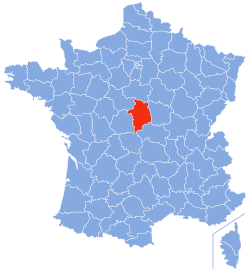
Location of Cher in France
Cher (/ʃɛər/ shair; French: [ʃɛʁ]; Berrichon: Char) is a department in central France, part of the Centre-Val de Loire region. Named after the river Cher, its prefecture is Bourges. In 2019, it had a population of 302,306.[3]
History
Cher is one of the original 83 departments created during the French Revolution on 4 March 1790. Most of it was created, along with the adjacent department of Indre from the former province of Berry. The southeastern corner of the department, however, was part of the Duchy of Bourbon.
Geography
The department is part of the current administrative region of Centre-Val de Loire. It is surrounded by the departments of Indre, Loir-et-Cher, Loiret, Nièvre, Allier, and Creuse.
Principal towns
The most populous commune is Bourges, the prefecture. As of 2019, there are 8 communes with more than 5,000 inhabitants:[3]
| Commune | Population (2019) |
|---|---|
| Bourges | 64,541 |
| Vierzon | 25,464 |
| Saint-Doulchard | 9,607 |
| Saint-Amand-Montrond | 9,488 |
| Mehun-sur-Yèvre | 6,555 |
| Saint-Florent-sur-Cher | 6,442 |
| Aubigny-sur-Nère | 5,502 |
| Saint-Germain-du-Puy | 5,041 |
Demographics
The inhabitants of the department are called Chériens or Berrichons after the former province of Berry.[4]
|
| |||||||||||||||||||||||||||||||||||||||||||||||||||||||||||||||||||||||||||||||||||||||
| ||||||||||||||||||||||||||||||||||||||||||||||||||||||||||||||||||||||||||||||||||||||||
| Sources:[5][6] | ||||||||||||||||||||||||||||||||||||||||||||||||||||||||||||||||||||||||||||||||||||||||
Politics
The President of the General Council is Jacques Fleury of The Republicans, elected in July 2021.[7]
| Party | seats | |
|---|---|---|
| Union for a Popular Movement | 10 | |
| • | Socialist Party | 9 |
| • | French Communist Party | 7 |
| Miscellaneous Right | 5 | |
| • | Miscellaneous Left | 4 |
Current National Assembly representatives
| Constituency | Member[8] | Party | |
|---|---|---|---|
| 1st | François Cormier-Bouligeon | La République En Marche! | |
| 2nd | Nadia Essayan | MoDem | |
| 3rd | Loïc Kervran | La République En Marche! | |
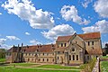
Tourism
The Bourges Cathedral of St. Étienne is a major tourist attraction.
-

-

-

-
-
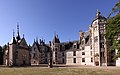 Château de Meillant


Languages
The historical languages are Berrichon and the northern version of Bourbonnais. These are both dialects of French, or the Langues d'oïl. They are named respectively after the former Province of Berry and the former Duchy of Bourbon. Some 11 communes in the extreme South used to speak Occitan.
The old dialects were in widespread use until the middle decades of the twentieth century and incorporated major regional variations within the department, influenced by the dialects of adjacent regions near the departmental frontiers. During the twentieth century government educational policy promoted a more standardised version of the French language.
In the extreme south of the department influence from the southern Occitan language begins to appear, with "chambrat" being used in place of "grenier a foin" (hayloft), "betoulle" in place of "bouleau" (birch tree) and "aigue" in place of "eau" (water).
See also
- Cantons of the Cher department
- Communes of the Cher department
- Arrondissements of the Cher department
References
- ^ "Répertoire national des élus: les conseillers départementaux". data.gouv.fr, Plateforme ouverte des données publiques françaises (in French). 4 May 2022.
- ^ "Téléchargement du fichier d'ensemble des populations légales en 2021". The National Institute of Statistics and Economic Studies. 28 December 2023.
- ^ a b Populations légales 2019: 18 Cher, INSEE
- ^ Cher, habitants.fr
- ^ "Historique du Cher". Le SPLAF.
- ^ "Évolution et structure de la population en 2016". INSEE.
- ^ Simon, Frank (1 July 2021). "Politique - Jacques Fleury, élu président du conseil départemental du Cher". leberry.fr (in French). Retrieved 7 July 2022.
- ^ Nationale, Assemblée. "Assemblée nationale ~ Les députés, le vote de la loi, le Parlement français". Assemblée nationale.
External links
- (in French) Departmental Council of Cher
- (in French) Prefecture of Cher
- (in English) Cher at Curlie
- v
- t
- e

- 01 Ain
- 02 Aisne
- 03 Allier
- 04 Alpes-de-Haute-Provence
- 05 Hautes-Alpes
- 06 Alpes-Maritimes
- 07 Ardèche
- 08 Ardennes
- 09 Ariège
- 10 Aube
- 11 Aude
- 12 Aveyron
- 13 Bouches-du-Rhône
- 14 Calvados
- 15 Cantal
- 16 Charente
- 17 Charente-Maritime
- 18 Cher
- 19 Corrèze
- 2A Corse-du-Sud
- 2B Haute-Corse
- 21 Côte-d'Or
- 22 Côtes-d'Armor
- 23 Creuse
- 24 Dordogne
- 25 Doubs
- 26 Drôme
- 27 Eure
- 28 Eure-et-Loir
- 29 Finistère
- 30 Gard
- 31 Haute-Garonne
- 32 Gers
- 33 Gironde
- 34 Hérault
- 35 Ille-et-Vilaine
- 36 Indre
- 37 Indre-et-Loire
- 38 Isère
- 39 Jura
- 40 Landes
- 41 Loir-et-Cher
- 42 Loire
- 43 Haute-Loire
- 44 Loire-Atlantique
- 45 Loiret
- 46 Lot
- 47 Lot-et-Garonne
- 48 Lozère
- 49 Maine-et-Loire
- 50 Manche
- 51 Marne
- 52 Haute-Marne
- 53 Mayenne
- 54 Meurthe-et-Moselle
- 55 Meuse
- 56 Morbihan
- 57 Moselle
- 58 Nièvre
- 59 Nord
- 60 Oise
- 61 Orne
- 62 Pas-de-Calais
- 63 Puy-de-Dôme
- 64 Pyrénées-Atlantiques
- 65 Hautes-Pyrénées
- 66 Pyrénées-Orientales
- 67 Bas-Rhin
- 68 Haut-Rhin
- 69D Rhône
- 70 Haute-Saône
- 71 Saône-et-Loire
- 72 Sarthe
- 73 Savoie
- 74 Haute-Savoie
- 76 Seine-Maritime
- 77 Seine-et-Marne
- 78 Yvelines
- 79 Deux-Sèvres
- 80 Somme
- 81 Tarn
- 82 Tarn-et-Garonne
- 83 Var
- 84 Vaucluse
- 85 Vendée
- 86 Vienne
- 87 Haute-Vienne
- 88 Vosges
- 89 Yonne
- 90 Territoire de Belfort
- 91 Essonne
- 92 Hauts-de-Seine
- 93 Seine-Saint-Denis
- 94 Val-de-Marne
- 95 Val-d'Oise
- 971 Guadeloupe
- 972 Martinique (territorial collectivity)
- 973 French Guiana (territorial collectivity)
- 974 Réunion
- 976 Mayotte
- 975 Saint Pierre and Miquelon (Overseas collectivity)
Authority control databases | |
|---|---|
| International |
|
| National |
|
| Geographic |
|
| Other |
|


