Cricket Mountains

Cricket Mountains
Cricket Mountains in Utah
(southwest)-Sevier Desert
- Sevier Lake-W
- House Range-W
- Sevier Desert-W, N & E
- Utah State Route 257-E & SE
- Black Rosk, UT-SE
- San Francisco Mountains-SW
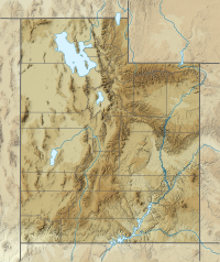
The Cricket Mountains are a 35-mile (56 km) long mountain range located in central-south Millard County, Utah, United States,[1] on the east border of Sevier Lake, in the Great Basin Desert.[2]
The southwestern Cricket Mountains merge southwest into the smaller San Francisco Mountains on the southern border of Sevier Lake and on the east of Wah Wah Valley.
Description
The Cricket Mountains rise to peaks ranging from the 6,000-foot (1,800 m) elevation to its highpoint of Headlight Mountain, 6,749 feet (2,057 m),[3] in the extreme southwest of the range. The Cricket Mountains are bordered by the Sevier Desert on the east, north, and west, where the Sevier River flows west then southwest into Sevier Lake, on the range's west border.
The southwest of the range merges into the northeast of the San Francisco Mountains, a slightly smaller range. Both ranges trend southwesterly x northeast, presumably part of Basin and Range block faulting.
Graymont Lime
Graymont Lime has a plant in the Cricket Mountains, about 35 miles (56 km) southwest of Delta. It is one of the 10 largest lime plants in the United States. It was previously owned by Continental Lime, which was purchased by Graymont Lime.
See also
 Mountains portal
 Utah portal


References
- ^ U.S. Geological Survey Geographic Names Information System: Cricket Mountains
- ^ Google (24 Mar 2020). "Cricket Mountains, Utah" (Map). Google Maps. Google. Retrieved 24 Mar 2020.
- ^ Utah, DeLorme Atlas & Gazetteer, p. 40-41.
External links
Wikimedia Commons has media related to Cricket Mountains.
- Headlight Mountain, mountainzone (coordinates)
- Cricket Mountains at Peakbagger.com
- Cricket Mountain Plant at Graymont Lime
- v
- t
- e


