Dargo, Victoria
Town in Victoria, Australia
37°29′S 147°16′E / 37.483°S 147.267°E / -37.483; 147.267- 314 km (195 mi) E of Melbourne
- 100 km (62 mi) N of Sale
- 68 km (42 mi) N of Briagolong
- Shire of Wellington
- Alpine Shire
Dargo is a town in Victoria, Australia, located 348 kilometres (216 mi) east of Melbourne, in the Shire of Wellington. At the 2016 census, Dargo and the surrounding area had a population of 99.[2] The median age of residents was 63.
The town provided a stopover for Victorian Gold Rush miners on their way to the goldfields of Grant, Talbotville, and Crooked River. The Post Office opened on 18 March 1868.[3]
Today the town is a producer of timber and beef cattle, and outside these industries tourism has become a major source of revenue. The town is a popular destination for four-wheel drive enthusiasts, bushwalkers, sambar deer hunters, and trout fishermen. An annual Walnut Festival formerly ran through the Australian Easter holiday period and was usually well attended.
-
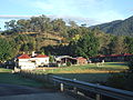 The Dargo Hotel, a major social gathering point for the district.
 -
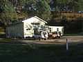
 The Dargo Store, an important refuel and resupply point.
 -
 The Dargo Community Hall.


References
Wikimedia Commons has media related to Dargo, Victoria.
Wikivoyage has a travel guide for Dargo.
- ^ Australian Bureau of Statistics (27 June 2017). "Dargo (State Suburb)". 2016 Census QuickStats. Retrieved 20 August 2020.

- ^ Australian Bureau of Statistics (27 June 2017). "2016 Community Profiles: Dargo". 2016 Census of Population and Housing. Retrieved 19 March 2019.
- ^ Phoenix Auctions History, Post Office List, retrieved 12 March 2021
External links
- Australian Places - Dargo
- v
- t
- e
Localities in the Shire of Wellington

- Alberton
- Boisdale
- Briagolong
- Bundalaguah
- Cobains
- Coongulla
- Cowwarr^
- Denison
- Devon North
- East Sale
- Fulham
- Glengarry^
- Glenmaggie
- Golden Beach
- Gormandale
- Heyfield
- Loch Sport
- Longford
- Maffra
- Nambrok
- Newry
- Port Albert
- Rosedale
- Seaspray
- Stratford
- Tinamba
- Toongabbie^
- Woodside
- Wurruk
- Yarram
- Airly
- Alberton West
- Arbuckle
- Balook^
- Billabong
- Binginwarri^
- Blackwarry
- Budgee Budgee
- Buragwonduc
- Bushy Park
- Callignee North
- Callignee South
- Calrossie
- Carrajung
- Carrajung Lower
- Carrajung South
- Clydebank
- Cowa
- Crookayan
- Crooked River
- Dargo^
- Darriman
- Dawson
- Dutson
- Dutson Downs
- Fernbank^
- Flamingo Beach
- Flynn^
- Flynns Creek^
- Gelliondale
- Giffard
- Giffard West
- Gillum
- Glenfalloch
- Glomar Beach
- Grand Ridge^
- Hawkhurst
- Hedley^
- Hiamdale
- Hiawatha
- Hollands Landing
- Howitt Plains
- Hunterston
- Jack River
- Kilmany
- Koorool
- Lake Wellington
- Langsborough
- Licola
- Licola North
- Llowalong
- Macks Creek
- Madalya
- Maffra West Upper
- Manns Beach
- McLoughlins Beach
- Meerlieu
- Miowera
- Monomak
- Montgomery
- Moornapa
- Moroka
- Munro
- Myrtlebank
- Nap Nap Marra
- Ocean Grange^
- Paradise Beach
- Pearsondale
- Perry Bridge
- Reynard^
- Riverslea
- Robertsons Beach
- Sargood
- Seacombe
- Seaton
- Snake Island
- Staceys Bridge
- Stockdale
- Stradbroke
- Tamboritha
- Tarra Valley
- Tarraville
- The Heart
- The Honeysuckles
- Tinamba West
- Toolome
- Valencia Creek
- Walhalla^
- Walhalla East
- Willung
- Willung South
- Winnindoo
- Won Wron
- Wongungarra^
- Wonyip
- Woodside Beach
- Woodside North
- Woolenook
- Worrowing
- Wrathung
- Wrixon
- Yangoura
^ - Territory divided with another LGA
Localities in the Alpine Shire | ||
|---|---|---|
| Town |
|  |
| Locality |
| |
^ - Territory divided with another LGA | ||


