Darran Mountains
44°40′S 168°05′E / 44.667°S 168.083°E / -44.667; 168.083
PreꞒ
Ꞓ
O
S
D
C
P
T
J
K
Pg
N
↓
The Darran Mountains are a prominent range within New Zealand's Fiordland National Park, the country's biggest national park. They contain the park's highest peak, Mount Tūtoko (2,723 metres (8,934 ft)).
Geography
The range lies between Milford Sound (Piopiotahi) and the valley of the Cleddau River (to the west) and the broad valley of the Hollyford River to the east at the northern end of the national park. They are bounded to the south by the Homer Saddle, which separates them from the Wick Mountains, and to the north by the coast of the Tasman Sea. The Homer Tunnel lies under the southwesternmost extreme of the range.[3]
Other than Mount Tūtoko, other prominent peaks in the range include Mount Madeline and Mount Christina. Numerous lakes and tarns are found within the range, among the largest being Lake Adelaide and Lake Marian, and several rivers have their watershed in the mountains, such as the Tūtoko, Kaipo, and Bowen Rivers. The Bowen River, close to its mouth, provides one of Milford Sound's more notable natural attractions, the Bowen Falls.[3]
The mountains were named by Captain J. Stokes, an early surveyor of the West Coast of the South Island.[4]
| Peak | Height[1] | Coordinate[1] | Picture |
|---|---|---|---|
| Mount Tūtoko | 2,723 metres (8,934 ft) | 44°35′41″S 168°00′45″E / 44.59460°S 168.01254°E / -44.59460; 168.01254 |  |
| Mount Madeline | 2,536 metres (8,320 ft) | 44°36′51″S 168°02′45″E / 44.61420°S 168.04589°E / -44.61420; 168.04589 | |
| Mount Christina | 2,474 metres (8,117 ft) | 44°47′35″S 168°02′55″E / 44.79310°S 168.04849°E / -44.79310; 168.04849 | |
| Mount Te Wera | 2,309 metres (7,575 ft) | 44°39′30″S 168°03′15″E / 44.65841°S 168.05429°E / -44.65841; 168.05429 | |
| Mount Crosscut | 2,263 m (7,425 ft) | 44°45′50″S 168°01′51″E / 44.76402°S 168.03086°E / -44.76402; 168.03086 |  |
| Mount Patuki | 2,246 metres (7,369 ft) | 44°40′09″S 168°01′24″E / 44.66920°S 168.02344°E / -44.66920; 168.02344 | |
| Mount Grave | 2,225 metres (7,300 ft) | 44°35′32″S 167°57′12″E / 44.59230°S 167.95345°E / -44.59230; 167.95345 | |
| Mount Syme | 2,188 metres (7,178 ft) | 44°37′37″S 168°01′56″E / 44.62697°S 168.03213°E / -44.62697; 168.03213 | |
| Paranui Peak | 2,167 metres (7,110 ft) | 44°34′17″S 167°58′44″E / 44.57128°S 167.97893°E / -44.57128; 167.97893 | |
| Mount Gifford | 2,149 metres (7,051 ft) | 44°43′30″S 168°04′33″E / 44.72506°S 168.07589°E / -44.72506; 168.07589 | |
| Mount Tuhawaiki | 2,092 metres (6,864 ft) | 44°41′02″S 168°04′39″E / 44.68385°S 168.07761°E / -44.68385; 168.07761 | |
| Mount Pembroke | 2,015 m (6,611 ft) | 44°34′05″S 167°53′08″E / 44.56794°S 167.88565°E / -44.56794; 167.88565 | |
| Barren Peak | 1,561 m (5,121 ft) | 44°39′41″S 167°57′03″E / 44.66148°S 167.95070°E / -44.66148; 167.95070 |  |
| Rover Peak | 1,524 m (5,000 ft) | 44°35′09″S 167°51′17″E / 44.58596°S 167.85483°E / -44.58596; 167.85483 | |
| The Lion | 1,302 m (4,272 ft) | 44°36′35″S 167°53′03″E / 44.60983°S 167.88425°E / -44.60983; 167.88425 |
Geology
The highest mountains are predominantly composed of a biotite from volcanic diorite dated to 138 ± 2.9 Ma and with younger intusion dykes of say quartz monzodiorite dated at 136 ± 1.9 Ma.[2] These rocks are part of the Median Tectonic Zone that separates the Western and Eastern provinces of Zealandia rocks. They cover an area of about 740 km2 (290 sq mi).[2] The mountains also have components to their north of rocks such as metamorphosed sandstone and gneiss from the Western Province. In the south eastern tip is found quartz diorite.[2]
Climbing
Many of the mountains have known mountain climbing routes.[5]
-
 The portal of Homer Tunnel is the most south western extreme of the Darran Mountains
 -
 Mount Crosscut in view almost due north from State Highway 94 on its way towards Homer Tunnel from the east.
 -
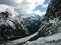
![View from head of Milford Sound of some of the Darrant Mountains on the north side of sound being The Lion and beyond it Rover Peak 1,524 m (5,000 ft)[1] and snow covered Mount Pembroke 2,015 m (6,611 ft).[1]](//upload.wikimedia.org/wikipedia/commons/thumb/b/b3/Milford_Sound_in_Fiordland_National_Park_11.jpg/120px-Milford_Sound_in_Fiordland_National_Park_11.jpg) View from head of Milford Sound of some of the Darrant Mountains on the north side of sound being The Lion and beyond it Rover Peak 1,524 m (5,000 ft)[1] and snow covered Mount Pembroke 2,015 m (6,611 ft).[1]
View from head of Milford Sound of some of the Darrant Mountains on the north side of sound being The Lion and beyond it Rover Peak 1,524 m (5,000 ft)[1] and snow covered Mount Pembroke 2,015 m (6,611 ft).[1]


![View from head of Milford Sound of some of the Darrant Mountains on the north side of sound being The Lion and beyond it Rover Peak 1,524 m (5,000 ft)[1] and snow covered Mount Pembroke 2,015 m (6,611 ft).[1]](http://upload.wikimedia.org/wikipedia/commons/thumb/b/b3/Milford_Sound_in_Fiordland_National_Park_11.jpg/120px-Milford_Sound_in_Fiordland_National_Park_11.jpg)
References
- ^ a b c d e NZTopoMap:Milford Sound
- ^ a b c d A Wandres; SD Weaver; D Shelley; JD Bradshaw (1998). "Diorites and associated intrusive and metamorphic rocks of the Darran Complex, Mount Underwood, Milford, southwest New Zealand". New Zealand Journal of Geology and Geophysics. 41 (1): 1–14. doi:10.1080/00288306.1998.9514786.
- ^ a b Dowling, P. (ed.) (2004). ’’Reed New Zealand atlas’’. Auckland: Reed Publishing. Map 89. ISBN 0 7900 0952 8
- ^ Reed, A.W. (1975). Place names of New Zealand. Wellington: A.H. & A.W. Reed. p. 99.
- ^ "ClimbNZ:Darran Mountains (457 routes)". Retrieved 15 March 2023.
- v
- t
- e
Fiordland, New Zealand
- Big Bay
- Martins Bay
- Pearl Harbour
- Te Waewae Bay
- Anchor Island
- Arran Island
- Bauza Island
- Bay Rock
- Belle Vue Island
- Breaksea Island
- Brig Rock
- Buncrana Island
- Centre Island
- Chalky Island
- Coal Island
- Cooper Island
- Elizabeth Island
- Great Island
- Indian Island
- Long Island
- Pomona Island
- Resolution Island
- Secretary Island
- Hawea (Clio Rocks)
- Kahukura (Gold Arm)
- Kutu Parera (Gaer Arm)
- Moana Uta (Wet Jacket Arm)
- Piopiotahi (Milford Sound)
- Taipari Roa (Elizabeth Island)
- Taumoana (Five Finger Peninsula)
- Te Awaatu Channel (The Gut)
- Te Hapua (Sutherland Sound)
- Te Tapuwae o Hua (Long Sound)
- Darran Mountains
- Franklin Mountains
- Humboldt Mountains
- Hunter Mountains
- Kepler Mountains
- Murchison Mountains
- Wick Mountains
- Mitre Peak
- Mount Edgecumbe
- Mount Grono
- Mount Luxmore
- Mount Moturau
- Mount Richardson
- Mount Titiroa
- Mount Tūtoko
- Aan River
- Arthur River
- Awarua River
- Big River
- Bowen River
- Camelot River
- Carrick River
- Castle River
- Cavendish River
- Cleddau River
- Clinton River
- Coal River
- Dark River
- Donne River
- Doon River
- Dry Awarua River
- Edith River
- Eglinton River
- Electric River
- Elizabeth River
- Forgotten River
- George River
- Glaisnock River
- Gray River
- Grebe River
- Gulliver River
- Hollyford River
- Irene River
- John o'Groats River
- Juno River
- Kaipo River
- Light River
- Lyvia River
- Mike River
- Misty River
- Monowai River
- Namu River
- Newton River
- Olivine River
- Pandora River
- Pitt River
- Pyke River
- Rea River
- Red Pyke River
- Rooney River
- Seaforth River
- Shag River
- Spey River
- Stillwater River
- Talbot River
- Thurso River
- Transit River
- Tūtoko River
- Waiau River
- Waikōau River
- Wairaurāhiri River
- Waitutu River
- Walker River
- Wapiti River
- Whitewater River
- Wild Natives River
- Wilmot River
- Wilson River
- Windward River
- Wolff River
- Manapouri
- Milford Sound
- Port Craig
- Te Anau


