DeBaliviere Place, St. Louis
Neighborhood of St. Louis in Missouri, United States
DeBaliviere Place | |
|---|---|
Neighborhood of St. Louis | |
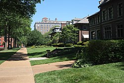 Washington Terrace, DeBaliviere Place, June 2017 | |
 Location (red) of DeBaliviere Place within St. Louis | |
| Country | United States |
| State | Missouri |
| City | St. Louis |
| Wards | 26, 28 |
| Area | |
| • Total | 0.32 sq mi (0.8 km2) |
| Population (2020)[1] | |
| • Total | 3,651 |
| • Density | 11,000/sq mi (4,400/km2) |
| ZIP code(s) | Part of 63112 |
| Area code(s) | 314 |
| Website | stlouis-mo.gov |
DeBaliviere Place (/dəˈbɑːləvər/ duh-BAH-lih-ver) is a neighborhood of St. Louis, Missouri.
Location
The DeBaliviere Place neighborhood is bounded by Delmar Boulevard on the north, Union Boulevard on the east, Lindell Boulevard on the south, and DeBaliviere Avenue on the west.
Characteristics
DeBaliviere Place has a diverse array of housing stock, ranging from older, grandiose single-family homes, to modern, renovated apartments and condominiums. The section of Lindell Boulevard within the neighborhood is home to a number of large mansions that overlook Forest Park. Washington Terrace, Kingsbury, and Waterman Places are examples of St. Louis' unique private places, streets that are owned by the residents and are lined with historic 19th-century houses. Union Boulevard has numerous old high-rise apartment buildings. The neighborhood has two private swimming pools and tennis courts for residents’ recreational use.
Shops and businesses line DeBaliviere, Belt, Clara, and Delmar. The MetroLink's Forest Park-DeBaliviere stop is located within the neighborhood. The neighborhood is across the street from Forest Park, adjacent to the Central West End, and close to both the Delmar Loop and Washington University.
Demographics
| Year | Pop. | ±% |
|---|---|---|
| 1990 | 3,271 | — |
| 2000 | 3,436 | +5.0% |
| 2010 | 3,466 | +0.9% |
| 2020 | 3,651 | +5.3% |
| [2] | ||
In 2020 the neighborhood's population was 55.0% White, 25.0% Black, 0.3% Native American, 10.9% Asian, 6.9% Two or More Races, and 1.9% Some Other Race. 5.0% of the population was of Hispanic or Latino origin.
| Racial composition | 1990[3] | 2000[4] | 2010[5] | 2020[6] |
|---|---|---|---|---|
| White | 59.2% | 59.3% | 59.0% | 55.0% |
| Black or African American | 38.1% | 30.2% | 29.4% | 25.0% |
| Hispanic or Latino (of any race) | N/A | 1.5% | 3.0% | 5.0% |
| Asian | N/A | 7.1% | 7.8% | 10.9% |
References
- v
- t
- e
- Academy
- Baden
- Benton Park
- Benton Park West
- Bevo Mill
- Botanical Heights
- Boulevard Heights
- Carondelet
- Carr Square
- Central West End
- Cheltenham
- Chinatown (defunct since 1966)
- Clayton/Tamm
- Clifton Heights
- College Hill
- Columbus Square
- Compton Heights
- Covenant Blu Grand Center
- DeBaliviere Place
- "Dogtown"
- Downtown
- Downtown West
- Dutchtown
- Ellendale
- Fairground
- Forest Park Southeast
- Fountain Park
- Fox Park
- Franz Park
- Gate District
- Gravois Park
- Greater Ville
- Hamilton Heights
- The Hill
- Hi-Pointe
- Holly Hills
- Hyde Park
- JeffVanderLou
- Kings Oak
- Kingsway East
- Kingsway West
- Kosciusko
- Lafayette Square
- LaSalle Park
- Lewis Place
- Lindenwood Park
- Marine Villa
- Mark Twain
- Mark Twain/I-70 Industrial
- McKinley Heights
- Midtown
- Mill Creek Valley (defunct since 1960s)
- Mount Pleasant
- Near North Riverfront
- Northampton
- North Point
- North Riverfront
- O'Fallon
- Old North St. Louis
- Patch
- Peabody–Darst–Webbe
- Penrose
- Princeton Heights
- Riverview
- Shaw
- Skinker DeBaliviere
- Soulard
- Southampton
- Southwest Garden
- St. Louis Hills
- St. Louis Place
- Tiffany
- Tower Grove East
- Tower Grove South
- Vandeventer
- The Ville
- Visitation Park
- Walnut Park East
- Walnut Park West
- Wells/Goodfellow
- West End
- Wydown/Skinker
38°39′00″N 90°16′47″W / 38.6500°N 90.2796°W / 38.6500; -90.2796
 | This St. Louis location article is a stub. You can help Wikipedia by expanding it. |
- v
- t
- e


