Diano Arentino
Comune in Liguria, Italy
Diano Arentino Dian Arentin | |
|---|---|
Comune | |
| Comune di Diano Arentino | |
 Diano Arentino | |
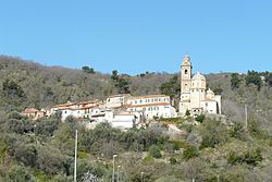
Location of Diano Arentino  | |
43°57′N 8°2′E / 43.950°N 8.033°E / 43.950; 8.033 | |
| Country | Italy |
| Region | Liguria |
| Province | Province of Imperia (IM) |
| Government | |
| • Mayor | Paolo Sciandino |
| Area | |
| • Total | 8.3 km2 (3.2 sq mi) |
| Population (Dec. 2004)[2] | |
| • Total | 648 |
| • Density | 78/km2 (200/sq mi) |
| Time zone | UTC+1 (CET) |
| • Summer (DST) | UTC+2 (CEST) |
| Postal code | 18013 |
| Dialing code | 0183 |
Diano Arentino (Ligurian: Dian Arentin[3]) is a comune (municipality) in the Province of Imperia in the Italian region Liguria, located about 90 kilometres (56 mi) southwest of Genoa and about 7 kilometres (4 mi) north of Imperia. As of 31 December 2004, it had a population of 648 and an area of 8.3 square kilometres (3.2 sq mi).[4]
Diano Arentino borders the following municipalities: Chiusanico, Diano Castello, Diano San Pietro, Imperia, Pontedassio, and Stellanello.
Demographic evolution

See also
- San Pietro (creek)
Wikimedia Commons has media related to Diano Arentino.
References
- ^ "Superficie di Comuni Province e Regioni italiane al 9 ottobre 2011". Italian National Institute of Statistics. Retrieved 16 March 2019.
- ^ "Popolazione Residente al 1° Gennaio 2018". Italian National Institute of Statistics. Retrieved 16 March 2019.
- ^ Frisoni, Gaetano [in Italian] (1910–2002). Nomi propri di città, borghi e villaggi della Liguria del Dizionario Genovese-Italiano e Italiano-Genovese (in Italian). Genova: Nuova Editrice Genovese.
- ^ All demographics and other statistics: Italian statistical institute Istat.
- v
- t
- e
- Airole
- Apricale
- Aquila d'Arroscia
- Armo
- Aurigo
- Badalucco
- Bajardo
- Bordighera
- Borghetto d'Arroscia
- Borgomaro
- Camporosso
- Caravonica
- Castellaro
- Castel Vittorio
- Ceriana
- Cervo
- Cesio
- Chiusanico
- Chiusavecchia
- Cipressa
- Civezza
- Costarainera
- Diano Arentino
- Diano Castello
- Diano Marina
- Diano San Pietro
- Dolceacqua
- Dolcedo
- Imperia
- Isolabona
- Lucinasco
- Mendatica
- Molini di Triora
- Montalto Carpasio
- Montegrosso Pian Latte
- Olivetta San Michele
- Ospedaletti
- Perinaldo
- Pietrabruna
- Pieve di Teco
- Pigna
- Pompeiana
- Pontedassio
- Pornassio
- Prelà
- Ranzo
- Rezzo
- Riva Ligure
- Rocchetta Nervina
- San Bartolomeo al Mare
- San Biagio della Cima
- San Lorenzo al Mare
- Sanremo
- Santo Stefano al Mare
- Seborga
- Soldano
- Cosio di Arroscia
- Taggia
- Terzorio
- Triora
- Vallebona
- Vallecrosia
- Vasia
- Ventimiglia
- Vessalico
- Villa Faraldi
 | This Liguria location article is a stub. You can help Wikipedia by expanding it. |
- v
- t
- e


