Dienville
Commune in Grand Est, France
Commune in Grand Est, France

Coat of arms
Location of Dienville

(2020–2026) Claude Large[1]
1
(2021)[2]
10123 /10500
(avg. 128 m or 420 ft)
Dienville (French pronunciation: [djɛ̃vil]) is a commune in the Aube department in north-central France.
History
The village of Dienville is mentioned in 864 under the name Dienvilla. There remains an Ancient Roman road, a vestige of that era.
On 1 February 1814 the village was fought over during the Battle of La Rothiere.
Population
Dienville was the home of Abbé Courtalon Delestre (1735-1786), a historian and poet, and fr:Jean-Baptiste Courtalon (1740-1797), Cleric of the Chapel for Louis XV and Chaplain of Louis XVI.
| Year | Pop. | ±% |
|---|---|---|
| 1962 | 844 | — |
| 1968 | 844 | +0.0% |
| 1975 | 812 | −3.8% |
| 1982 | 781 | −3.8% |
| 1990 | 796 | +1.9% |
| 1999 | 747 | −6.2% |
| 2008 | 809 | +8.3% |
-
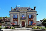 Town hall
 -
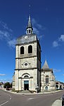 Saint Quentin church
 -
 Market hall
 -
 War memorial


See also
References
- ^ "Répertoire national des élus: les maires" (in French). data.gouv.fr, Plateforme ouverte des données publiques françaises. 13 September 2022.
- ^ "Populations légales 2021". The National Institute of Statistics and Economic Studies. 28 December 2023.
Wikimedia Commons has media related to Dienville.
- v
- t
- e
 Communes of the Aube department
- Ailleville
- Aix-Villemaur-Pâlis
- Allibaudières
- Amance
- Arcis-sur-Aube
- Arconville
- Argançon
- Arrelles
- Arrembécourt
- Arrentières
- Arsonval
- Assenay
- Assencières
- Aubeterre
- Aulnay
- Auxon
- Avant-lès-Marcilly
- Avant-lès-Ramerupt
- Avirey-Lingey
- Avon-la-Pèze
- Avreuil
- Bagneux-la-Fosse
- Bailly-le-Franc
- Balignicourt
- Balnot-la-Grange
- Balnot-sur-Laignes
- Barberey-Saint-Sulpice
- Barbuise
- Baroville
- Bar-sur-Aubesubpr
- Bar-sur-Seine
- Bayel
- Bercenay-en-Othe
- Bercenay-le-Hayer
- Bergères
- Bernon
- Bertignolles
- Bérulle
- Bessy
- Bétignicourt
- Beurey
- Blaincourt-sur-Aube
- Blignicourt
- Bligny
- Les Bordes-Aumont
- Bossancourt
- Bouilly
- Boulages
- Bouranton
- Bourdenay
- Bourguignons
- Bouy-Luxembourg
- Bouy-sur-Orvin
- Bragelogne-Beauvoir
- Braux
- Bréviandes
- Brévonnes
- Briel-sur-Barse
- Brienne-la-Vieille
- Brienne-le-Château
- Brillecourt
- Bucey-en-Othe
- Buchères
- Buxeuil
- Buxières-sur-Arce
- Celles-sur-Ource
- Chacenay
- La Chaise
- Chalette-sur-Voire
- Chamoy
- Champfleury
- Champignol-lez-Mondeville
- Champigny-sur-Aube
- Champ-sur-Barse
- Channes
- Chaource
- La Chapelle-Saint-Luc
- Chapelle-Vallon
- Chappes
- Charmont-sous-Barbuise
- Charmoy
- Charny-le-Bachot
- Chaserey
- Châtres
- Chauchigny
- Chaudrey
- Chauffour-lès-Bailly
- Chaumesnil
- Chavanges
- Le Chêne
- Chennegy
- Chervey
- Chesley
- Chessy-les-Prés
- Clérey
- Coclois
- Colombé-la-Fosse
- Colombé-le-Sec
- Cormost
- Courcelles-sur-Voire
- Courceroy
- Coursan-en-Othe
- Courtaoult
- Courtenot
- Courteranges
- Courteron
- Coussegrey
- Couvignon
- Crancey
- Creney-près-Troyes
- Crésantignes
- Crespy-le-Neuf
- Les Croûtes
- Cunfin
- Cussangy
- Dampierre
- Davrey
- Dienville
- Dierrey-Saint-Julien
- Dierrey-Saint-Pierre
- Dolancourt
- Dommartin-le-Coq
- Donnement
- Dosches
- Dosnon
- Droupt-Saint-Basle
- Droupt-Sainte-Marie
- Eaux-Puiseaux
- Échemines
- Éclance
- Éguilly-sous-Bois
- Engente
- Épagne
- Épothémont
- Ervy-le-Châtel
- Essoyes
- Estissac
- Étourvy
- Étrelles-sur-Aube
- Faux-Villecerf
- Fay-lès-Marcilly
- Fays-la-Chapelle
- Ferreux-Quincey
- Feuges
- Fontaine
- Fontaine-les-Grès
- Fontaine-Mâcon
- Fontenay-de-Bossery
- Fontette
- Fontvannes
- La Fosse-Corduan
- Fouchères
- Fralignes
- Fravaux
- Fresnay
- Fresnoy-le-Château
- Fuligny
- Gélannes
- Géraudot
- Les Grandes-Chapelles
- Grandville
- Les Granges
- Gumery
- Gyé-sur-Seine
- Hampigny
- Herbisse
- Isle-Aubigny
- Isle-Aumont
- Jasseines
- Jaucourt
- Javernant
- Jessains
- Jeugny
- Joncreuil
- Jully-sur-Sarce
- Juvancourt
- Juvanzé
- Juzanvigny
- Lagesse
- Laines-aux-Bois
- Landreville
- Lantages
- Lassicourt
- Laubressel
- Lavau
- Lentilles
- Lesmont
- Lévigny
- Lhuître
- Lignières
- Lignol-le-Château
- Lirey
- Loches-sur-Ource
- La Loge-aux-Chèvres
- La Loge-Pomblin
- Les Loges-Margueron
- Longchamp-sur-Aujon
- Longeville-sur-Mogne
- Longpré-le-Sec
- Longsols
- Longueville-sur-Aube
- La Louptière-Thénard
- Lusigny-sur-Barse
- Luyères
- Macey
- Machy
- Magnant
- Magnicourt
- Magny-Fouchard
- Mailly-le-Camp
- Maison-des-Champs
- Maisons-lès-Chaource
- Maisons-lès-Soulaines
- Maizières-la-Grande-Paroisse
- Maizières-lès-Brienne
- Maraye-en-Othe
- Marcilly-le-Hayer
- Marigny-le-Châtel
- Marnay-sur-Seine
- Marolles-lès-Bailly
- Marolles-sous-Lignières
- Mathaux
- Maupas
- Mergey
- Le Mériot
- Merrey-sur-Arce
- Méry-sur-Seine
- Mesgrigny
- Mesnil-la-Comtesse
- Mesnil-Lettre
- Mesnil-Saint-Loup
- Mesnil-Saint-Père
- Mesnil-Sellières
- Messon
- Metz-Robert
- Meurville
- Molins-sur-Aube
- Montaulin
- Montceaux-lès-Vaudes
- Montfey
- Montgueux
- Montiéramey
- Montier-en-l'Isle
- Montigny-les-Monts
- Montmartin-le-Haut
- Montmorency-Beaufort
- Montpothier
- Montreuil-sur-Barse
- Montsuzain
- Morembert
- Morvilliers
- La Motte-Tilly
- Moussey
- Mussy-sur-Seine
- Neuville-sur-Seine
- Neuville-sur-Vanne
- Noé-les-Mallets
- Les Noës-près-Troyes
- Nogent-en-Othe
- Nogent-sur-Aube
- Nogent-sur-Seinesubpr
- Nozay
- Onjon
- Origny-le-Sec
- Ormes
- Ortillon
- Orvilliers-Saint-Julien
- Ossey-les-Trois-Maisons
- Paisy-Cosdon
- Pargues
- Pars-lès-Chavanges
- Pars-lès-Romilly
- Le Pavillon-Sainte-Julie
- Payns
- Pel-et-Der
- Périgny-la-Rose
- Perthes-lès-Brienne
- Petit-Mesnil
- Piney
- Plaines-Saint-Lange
- Plancy-l'Abbaye
- Planty
- Plessis-Barbuise
- Poivres
- Poligny
- Polisot
- Polisy
- Pont-Sainte-Marie
- Pont-sur-Seine
- Pouan-les-Vallées
- Pougy
- Pouy-sur-Vannes
- Praslin
- Précy-Notre-Dame
- Précy-Saint-Martin
- Prémierfait
- Proverville
- Prugny
- Prunay-Belleville
- Prusy
- Puits-et-Nuisement
- Racines
- Radonvilliers
- Ramerupt
- Rances
- Rhèges
- Les Riceys
- Rigny-la-Nonneuse
- Rigny-le-Ferron
- Rilly-Sainte-Syre
- La Rivière-de-Corps
- Romilly-sur-Seine
- Roncenay
- Rosières-près-Troyes
- Rosnay-l'Hôpital
- La Rothière
- Rouilly-Sacey
- Rouilly-Saint-Loup
- Rouvres-les-Vignes
- Rumilly-lès-Vaudes
- Ruvigny
- Saint-André-les-Vergers
- Saint-Aubin
- Saint-Benoist-sur-Vanne
- Saint-Benoît-sur-Seine
- Saint-Christophe-Dodinicourt
- Sainte-Maure
- Sainte-Savine
- Saint-Étienne-sous-Barbuise
- Saint-Flavy
- Saint-Germain
- Saint-Hilaire-sous-Romilly
- Saint-Jean-de-Bonneval
- Saint-Julien-les-Villas
- Saint-Léger-près-Troyes
- Saint-Léger-sous-Brienne
- Saint-Léger-sous-Margerie
- Saint-Loup-de-Buffigny
- Saint-Lupien
- Saint-Lyé
- Saint-Mards-en-Othe
- Saint-Martin-de-Bossenay
- Saint-Mesmin
- Saint-Nabord-sur-Aube
- Saint-Nicolas-la-Chapelle
- Saint-Oulph
- Saint-Parres-aux-Tertres
- Saint-Parres-lès-Vaudes
- Saint-Phal
- Saint-Pouange
- Saint-Remy-sous-Barbuise
- Saint-Thibault
- Saint-Usage
- Salon
- Saulcy
- La Saulsotte
- Savières
- Semoine
- Soligny-les-Étangs
- Sommeval
- Soulaines-Dhuys
- Souligny
- Spoy
- Thennelières
- Thieffrain
- Thil
- Thors
- Torcy-le-Grand
- Torcy-le-Petit
- Torvilliers
- Traînel
- Trancault
- Trannes
- Trouans
- Troyespref
- Turgy
- Unienville
- Urville
- Vailly
- Val-d'Auzon
- Vallant-Saint-Georges
- Vallentigny
- Vallières
- Vanlay
- Vauchassis
- Vauchonvilliers
- Vaucogne
- Vaudes
- Vaupoisson
- Vendeuvre-sur-Barse
- La Vendue-Mignot
- Vernonvilliers
- Verpillières-sur-Ource
- Verricourt
- Verrières
- Viâpres-le-Petit
- Villacerf
- Villadin
- La Ville-aux-Bois
- Villechétif
- Villeloup
- Villemereuil
- Villemoiron-en-Othe
- Villemorien
- Villemoyenne
- Villenauxe-la-Grande
- La Villeneuve-au-Châtelot
- Villeneuve-au-Chemin
- La Villeneuve-au-Chêne
- Villeret
- Villery
- Ville-sous-la-Ferté
- Ville-sur-Arce
- Ville-sur-Terre
- Villette-sur-Aube
- Villiers-Herbisse
- Villiers-le-Bois
- Villiers-sous-Praslin
- Villy-en-Trodes
- Villy-le-Bois
- Villy-le-Maréchal
- Vinets
- Virey-sous-Bar
- Vitry-le-Croisé
- Viviers-sur-Artaut
- Voigny
- Vosnon
- Voué
- Vougrey
- Vulaines
- Yèvres-le-Petit
- pref: prefecture
- subpr: subprefecture
Authority control databases | |
|---|---|
| International |
|
| National |
|
 | This Aube geographical article is a stub. You can help Wikipedia by expanding it. |
- v
- t
- e


