Extreme points of Moldova
Map all coordinates using OpenStreetMap
Download coordinates as:
- KML
- GPX (all coordinates)
- GPX (primary coordinates)
- GPX (secondary coordinates)
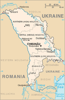
This is a list of the extreme points of Moldova: the points that are farther north, south, east or west than any other location, as well as the highest and lowest points in the country.
Extreme coordinates
| Heading | Location | District | Bordering entity | Coordinates[1] | Notes |
|---|---|---|---|---|---|
| North extreme | Naslavcea | Ocnița District | Ukraine | 48°29′28″N 27°35′19″E / 48.49111°N 27.58861°E / 48.49111; 27.58861 | |
| South extreme | Giurgiulești | Cahul District | Galați (Romania) & Reni (Ukraine) (Moldova/Romania/Ukraine tripoint) | 45°28′08″N 28°12′47″E / 45.46889°N 28.21306°E / 45.46889; 28.21306 | |
| West extreme | Criva | Briceni District | Păltiniș (Romania) & Dnistrovskyi Raion (Ukraine) (Moldova/Romania/Ukraine tripoint) | 48°16′27″N 26°36′59″E / 48.27417°N 26.61639°E / 48.27417; 26.61639 | |
| East extreme | Palanca | Ștefan Vodă District | Bilhorod-Dnistrovskyi Raion of Odesa Oblast (Ukraine) | 46°24′48″N 30°09′47″E / 46.41333°N 30.16306°E / 46.41333; 30.16306 |
Elevation extremes
- Highest point: Bălănești Hill (429 or 430 m) 47°13′01″N 28°05′00″E / 47.21694°N 28.08333°E / 47.21694; 28.08333
- Lowest point: Dniester river, same as East extreme (2 m)
See also
References
- ^ Coordinates obtained from Google Earth. Google Earth makes use of the WGS84 geodetic reference system.
- v
- t
- e

| Subdivisions |
|
|---|---|
|
| Culture | |
|---|---|


