Fair Play, South Carolina
Census-designated place in South Carolina, United States
CDP in South Carolina, United States
34°30′40″N 82°59′08″W / 34.51111°N 82.98556°W / 34.51111; -82.98556 (2020)[3]
29643
Fair Play is a census-designated place located in Oconee County in the U.S. state of South Carolina. A small portion of the CDP extends into Anderson County. As of the 2020 census, the population of Fair Play was 704.[4]
According to tradition, the name stems from an incident in which a bystander implored two brawling pioneers to "play fair".[5]
Geography
Fair Play is located in the southern corner of Oconee County, which occupies the northwestern corner of South Carolina. The CDP extends from the town center south to Lake Hartwell, a large reservoir on the South Carolina–Georgia line. Interstate 85 passes through the CDP, with access via exits 2 and 4. Greenville, South Carolina, is 44 miles (71 km) to the northeast, and Atlanta, Georgia, is 100 miles (160 km) to the southwest.
Demographics
As of the 2020 US Census, the population of the area is 704.
References
- ^ "ArcGIS REST Services Directory". United States Census Bureau. Retrieved October 15, 2022.
- ^ a b U.S. Geological Survey Geographic Names Information System: Fair Play, South Carolina
- ^ "Census Population API". United States Census Bureau. Retrieved October 15, 2022.
- ^ "Geographic Identifiers: 2010 Demographic Profile Data (G001): Fair Play CDP, South Carolina". U.S. Census Bureau, American Factfinder. Archived from the original on February 12, 2020. Retrieved August 8, 2013.
- ^ Moyer, Armond; Moyer, Winifred (1958). The origins of unusual place-names. Keystone Pub. Associates. p. 48.
- v
- t
- e
Municipalities and communities of Oconee County, South Carolina, United States
County seat: Walhalla

- Chickasaw Point
- Fair Play‡
- Keowee Key
- Longcreek
- Newry
- South Union
- Tamassee
- Utica
communities
- South Carolina portal
- United States portal
Municipalities and communities of Anderson County, South Carolina, United States | ||
|---|---|---|
County seat: Anderson | ||
| Cities | 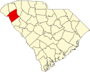 | |
| Towns | ||
| CDPs | ||
| Other communities | ||
| Footnotes | ‡This populated place also has portions in an adjacent county or counties | |
| ||
 | This South Carolina state location article is a stub. You can help Wikipedia by expanding it. |
- v
- t
- e


