Hédouville
Commune in Île-de-France, France

Coat of arms
Location of Hédouville

(2020–2026) Eric Couppe[1]
1
(2021)[2]
95304 /95690
Hédouville (French pronunciation: [eduvil] ⓘ) is a commune in the Val-d'Oise department in Île-de-France in northern France.
Geography
Hédouville is located just inside Île-de-France, on its border with Hauts-de-France. The town is part of the Parc Naturel Régional du Véxin Français.
Toponymy
The town name has German origins from Haidulf (name) and Latin villa (domain). Hédouville is therefore interpreted as "Domain of Haidulf".
-
 A flag with the coat of arms of Hédouville
 -
 A view of the church of Hédouville
 -
 The washing place
 -
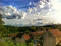 Looking south-west in the village


See also
References
- ^ "Répertoire national des élus: les maires" (in French). data.gouv.fr, Plateforme ouverte des données publiques françaises. 4 May 2022.
- ^ "Populations légales 2021". The National Institute of Statistics and Economic Studies. 28 December 2023.
External links
Wikimedia Commons has media related to Hédouville.
- Base Mérimée: Search for heritage in the commune, Ministère français de la Culture. (in French)
- Association of Mayors of the Val d'Oise (in French)
- v
- t
- e
Communes of the Val-d'Oise department 

- Ableiges
- Aincourt
- Ambleville
- Amenucourt
- Andilly
- Argenteuilsubpr
- Arnouville
- Arronville
- Arthies
- Asnières-sur-Oise
- Attainville
- Auvers-sur-Oise
- Avernes
- Baillet-en-France
- Banthelu
- Beauchamp
- Beaumont-sur-Oise
- Le Bellay-en-Vexin
- Bellefontaine
- Belloy-en-France
- Bernes-sur-Oise
- Berville
- Bessancourt
- Béthemont-la-Forêt
- Bezons
- Boisemont
- Boissy-l'Aillerie
- Bonneuil-en-France
- Bouffémont
- Bouqueval
- Bray-et-Lû
- Bréançon
- Brignancourt
- Bruyères-sur-Oise
- Buhy
- Butry-sur-Oise
- Cergyd.f. pref
- Champagne-sur-Oise
- La Chapelle-en-Vexin
- Charmont
- Chars
- Châtenay-en-France
- Chaumontel
- Chaussy
- Chauvry
- Chennevières-lès-Louvres
- Chérence
- Cléry-en-Vexin
- Commeny
- Condécourt
- Cormeilles-en-Parisis
- Cormeilles-en-Vexin
- Courcelles-sur-Viosne
- Courdimanche
- Deuil-la-Barre
- Domont
- Eaubonne
- Écouen
- Enghien-les-Bains
- Ennery
- Épiais-lès-Louvres
- Épiais-Rhus
- Épinay-Champlâtreux
- Éragny
- Ermont
- Ézanville
- Fontenay-en-Parisis
- Fosses
- Franconville
- Frémainville
- Frémécourt
- Frépillon
- La Frette-sur-Seine
- Frouville
- Garges-lès-Gonesse
- Genainville
- Génicourt
- Gonesse
- Goussainville
- Grisy-les-Plâtres
- Groslay
- Guiry-en-Vexin
- Haravilliers
- Haute-Isle
- Le Heaulme
- Hédouville
- Herblay-sur-Seine
- Hérouville-en-Vexin
- Hodent
- L'Isle-Adam
- Jagny-sous-Bois
- Jouy-le-Moutier
- Labbeville
- Lassy
- Livilliers
- Longuesse
- Louvres
- Luzarches
- Maffliers
- Magny-en-Vexin
- Mareil-en-France
- Margency
- Marines
- Marly-la-Ville
- Maudétour-en-Vexin
- Menouville
- Menucourt
- Mériel
- Méry-sur-Oise
- Le Mesnil-Aubry
- Moisselles
- Montgeroult
- Montigny-lès-Cormeilles
- Montlignon
- Montmagny
- Montmorency
- Montreuil-sur-Epte
- Montsoult
- Mours
- Moussy
- Nerville-la-Forêt
- Nesles-la-Vallée
- Neuilly-en-Vexin
- Neuville-sur-Oise
- Nointel
- Noisy-sur-Oise
- Nucourt
- Omerville
- Osny
- Parmain
- Le Perchay
- Persan
- Pierrelaye
- Piscop
- Le Plessis-Bouchard
- Le Plessis-Gassot
- Le Plessis-Luzarches
- Pontoisepref
- Presles
- Puiseux-en-France
- Puiseux-Pontoise
- La Roche-Guyon
- Roissy-en-France
- Ronquerolles
- Sagy
- Saint-Brice-sous-Forêt
- Saint-Clair-sur-Epte
- Saint-Cyr-en-Arthies
- Saint-Gervais
- Saint-Gratien
- Saint-Leu-la-Forêt
- Saint-Martin-du-Tertre
- Saint-Ouen-l'Aumône
- Saint-Prix
- Saint-Witz
- Sannois
- Santeuil
- Sarcellessubpr
- Seraincourt
- Seugy
- Soisy-sous-Montmorency
- Survilliers
- Taverny
- Théméricourt
- Theuville
- Le Thillay
- Us
- Vallangoujard
- Valmondois
- Vaudherland
- Vauréal
- Vémars
- Vétheuil
- Viarmes
- Vienne-en-Arthies
- Vigny
- Villaines-sous-Bois
- Villeron
- Villers-en-Arthies
- Villiers-Adam
- Villiers-le-Bel
- Villiers-le-Sec
- Wy-dit-Joli-Village
- d.f. pref: de facto prefecture
- pref: prefecture
- subpr: subprefecture
Authority control databases | |
|---|---|
| National |
|
| Geographic |
|
 | This Val-d'Oise geographical article is a stub. You can help Wikipedia by expanding it. |
- v
- t
- e


