Hattieville, Arkansas
Census-designated place in Arkansas, United States
35°17′15″N 92°47′13″W / 35.28750°N 92.78694°W / 35.28750; -92.78694 (2020)
72063
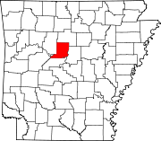
Hattieville is an unincorporated community and census-designated place (CDP) in Conway County, Arkansas, United States. It was first listed as a CDP in the 2020 census with a population of 132.[2] Hattieville is located on Arkansas Highway 213, 9.5 miles (15.3 km) north-northwest of Morrilton. Hattieville has a post office with ZIP code 72063.[3]
Demographics
| Census | Pop. | Note | %± |
|---|---|---|---|
| 2020 | 132 | — | |
| U.S. Decennial Census[4] 2020[5] | |||
2020 census
| Race / Ethnicity (NH = Non-Hispanic) | Pop 2020[5] | % 2020 |
|---|---|---|
| White alone (NH) | 129 | 97.73% |
| Black or African American alone (NH) | 0 | 0.00% |
| Native American or Alaska Native alone (NH) | 0 | 0.00% |
| Asian alone (NH) | 0 | 0.00% |
| Pacific Islander alone (NH) | 0 | 0.00% |
| Some Other Race alone (NH) | 0 | 0.00% |
| Mixed Race or Multi-Racial (NH) | 3 | 2.27% |
| Hispanic or Latino (any race) | 0 | 0.00% |
| Total | 132 | 100.00% |
References
- ^ a b U.S. Geological Survey Geographic Names Information System: Hattieville, Arkansas
- ^ "Hattieville CDP, Arkansas". United States Census Bureau. Retrieved April 7, 2022.
- ^ ZIP Code Lookup
- ^ "Decennial Census of Population and Housing by Decades". US Census Bureau.
- ^ a b "P2 Hispanic or Latino, and Not Hispanic or Latino by Race – 2020 - Hattieville CDP, Arkansas". United States Census Bureau.
- v
- t
- e
Municipalities and communities of Conway County, Arkansas, United States
County seat: Morrilton
- Center Ridge
- Hattieville
- Jerusalem
- Springfield
unincorporated
communities
- Arkansas portal
- United States portal
 | This article about a location in Conway County, Arkansas is a stub. You can help Wikipedia by expanding it. |
- v
- t
- e


