Låtefossen
Waterfall in Vestland, Norway
59°56′54″N 6°35′19″E / 59.948359°N 6.588498°E / 59.948359; 6.588498flow rate
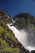
Låtefossen or Låtefoss is a waterfall located in Ullensvang Municipality in Vestland County, Norway. The 165-metre (541 ft) tall waterfall is unique and thus it is a well-known tourist attraction in the area. It is special in that it consists of two separate streams flowing down from the lake Lotevatnet, and as they fall, they join in the middle of the waterfall, just before going under the Norwegian National Road 13 built in 1867–69, making for a spectacular (and wet) view as one drives over the old, stone, six-arched bridge.[1][2]
Gallery
-
 View of the bridge
 -
 Section from Låtefossen
 -
 View of the falls
 -
 View of the visitors' center
 -


See also
- List of waterfalls § Norway
 Media related to Låtefossen at Wikimedia Commons
References
| Authority control databases: Geographic |
|
|---|
- v
- t
- e


