Lake Warren State Park

State park in South Carolina, United States

  • Lowcountry discovery trail (1.1 mi)
  • nature trail (0.3 mi)
Other informationFree admission
Hours: 9 a.m. to 6 p.m.
Pets: allowed, must be leashedWebsitehttp://www.southcarolinaparks.com/lakewarren/introduction.aspx

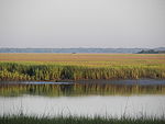
Lake Warren State Park is a 440-acre (1.8 km2) state park located 4 miles (6.4 km) southwest of Hampton, South Carolina, United States. Its main attraction is Lake Warren itself, which is locally popular for fishing, boating, and bird-watching. An additional smaller pond, a playground, and picnic facilities are located within the park. Primarily used for daylight hours, camping is allowed but is restricted to primitive sites.

References

  1. ^ "Lake Warren FAQs". southcarolinaparks.com. South Carolina State Parks. Retrieved August 28, 2022.

External links

  • Official state park website
  • v
  • t
  • e
The Lowcountry of South Carolina
Counties
Major communities
Sea islandsHistory & cultureMilitary installationsNatural areasOther articles
  • v
  • t
  • e
Federal
National Parks
National Historic Sites
and Historical Parks
National Military Parks
and Battlefields
National Historic Trail
National Forests
National
Wildlife Refuges
National Estuarine
Research Reserves
Wilderness Areas
Wild and Scenic River
State
State Parks
State Historic Sites
State Forests
Heritage Preserves
  • Aiken Gopher Tortoise
  • Altamaha Towne
  • Ashmore
  • Bald Rock
  • Bear Branch
  • Belvue Springs
  • Bennett's Bay
  • Blackwell
  • Botany Bay Plantation
  • Brasstown Creek
  • Bunched Arrowhead
  • Buzzard Island
  • Buzzard Roost
  • Capers Island
  • Cartwheel Bay
  • Cathedral Bay
  • Chestnut Ridge
  • Childsbury Towne
  • Clear Creek
  • Congaree Bluffs
  • Congaree Creek
  • Crosby Oxypolis
  • Daws Island
  • Ditch Pond
  • Dungannon Plantation
  • Eastatoe Creek
  • Eva Russell Chandler
  • Fort Frederick
  • Fort Lamar
  • Forty Acre Rock
  • Glassy Mountain
  • Gopher Branch
  • Great Pee Dee River
  • Green's Shell Enclosure
  • Henderson
  • Janet Harrison High Pond
  • Laurel Fork
  • Lewis Ocean Bay
  • Lighthouse Inlet
  • Little Pee Dee
  • Little Pee Dee State Park Bay
  • Long Branch Bay
  • Longleaf Pine
  • Lynchburg Savanna
  • Nipper Creek
  • Old Island
  • Pacolet River
  • Peachtree Rock
  • Peters Creek
  • Poinsett Bridge
  • Rock Hill Blackjacks
  • Savage Bay
  • Savannah River Bluffs
  • Segars-McKinnon
  • Shealy's Pond
  • South Bluff
  • St. Helena Sound
  • Stevens Creek
  • Stoney Creek Battery
  • Stumphouse Mountain
  • Tillman Sand Ridge
  • Tom Yawkey Wildlife Center
  • Victoria Bluff Heritage Preserve
  • Waccamaw River
  • Wadakoe Mountain
  • Wateree
  • Watson-Cooper
  • Woods Bay
Wildlife Management Areas
  • Bear Island
  • Belfast
  • Bonneau Ferry
  • Campbell's Crossroads
  • Canal
  • Causey Tract
  • Cliff Pitts
  • Clinton Reservoir Tract
  • Crackerneck
  • Donnelley
  • Draper
  • Edisto River
  • Fant's Grove
  • Gray Court Tract
  • Hamilton Ridge
  • Hatchery
  • Herbert Kirsh
  • Hickory Top
  • James L. Mason
  • James Ross
  • Jim Timmerman
  • Keowee
  • Landsford Canal Forest
  • Liberty Hill
  • Marsh
  • McBee
  • McCalla
  • McConnells Tract
  • Moultrie Hunt Unit
  • Nine Times
  • Oak Lea
  • Palachucola
  • Pee Dee Station
  • Samworth
  • Santee Coastal Reserve
  • Santee Cooper
  • Santee Cooper Tract
  • Santee Dam
  • Santee-Delta
  • Thurmond Tract
  • Turtle Island
  • Webb
  • Wild Turkey
  • Woodbury
  • Worth Mountain
Seabird Sanctuaries
  • Bay Point Shoal
  • Bird Key - Stono
  • Crab Bank
  • Deveaux Bank
  • Joiner Bank
  • North Santee Bar


Stub icon

This South Carolina state location article is a stub. You can help Wikipedia by expanding it.

  • v
  • t
  • e