List of Indiana state historical markers in Kosciusko County

This is a list of the Indiana state historical markers in Kosciusko County.
This is intended to be a complete list of the official state historical markers placed in Kosciusko County, Indiana, United States by the Indiana Historical Bureau. The locations of the historical markers and their latitude and longitude coordinates are included below when available, along with their names, years of placement, and topics as recorded by the Historical Bureau. There are 8 historical markers located in Kosciusko County.[1]
Map all coordinates using OpenStreetMap
Download coordinates as:
- KML
- GPX (all coordinates)
- GPX (primary coordinates)
- GPX (secondary coordinates)
Historical markers
| Marker title | Image | Year placed | Location | Topics |
|---|---|---|---|---|
| Papakeechie's Reserve[2] |  | 1962 | 7277 E. Eli Lilly Road along the northern shore of Lake Wawasee near Syracuse 41°25′2″N 85°42′20″W / 41.41722°N 85.70556°W / 41.41722; -85.70556 (Papakeechie's Reserve) | American Indian/Native American, Transportation |
| Indian Hill[3] | 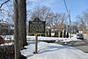 | 1962 | 877 N. Shore Drive, along Syracuse Lake near Syracuse 41°25′55″N 85°44′24″W / 41.43194°N 85.74000°W / 41.43194; -85.74000 (Indian Hill) | American Indian/Native American, Early Settlement and Exploration |
| Indiana's Glacier Lakes[4] |  | 1966 | Northeastern lawn of the Kosciusko County Courthouse in Warsaw 41°14′20″N 85°51′25″W / 41.23889°N 85.85694°W / 41.23889; -85.85694 (Indiana's Glacier Lakes) | Nature and Natural Disasters |
| Continental Divide[5] |  | 1968 | Eastern side of State Road 13 along the frontage of the Northern Indiana Weather Forecast Office facility, 2 miles north of North Webster and south of Syracuse 41°21′31″N 85°42′4″W / 41.35861°N 85.70111°W / 41.35861; -85.70111 (Continental Divide) | Nature and Natural Disasters |
| Site of Cowen Grove Seminary, 1851-1876[6] | 1976 | 311 S. Detroit Street in Warsaw 41°14′7.8″N 85°51′10″W / 41.235500°N 85.85278°W / 41.235500; -85.85278 (Site of Cowen Grove Seminary, 1851-1876) | Religion, Education | |
| Lawrence D. Bell[7] | 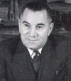 | 1995 | W. State Road 25 near Mentone 41°10′23.4″N 86°2′32″W / 41.173167°N 86.04222°W / 41.173167; -86.04222 (Lawrence D. Bell) | Science, Medicine, and Inventions, Transportation |
| Kosciusko County Jail[8] |  | 2003 | 121 N. Indiana in Warsaw 41°14′20″N 85°51′20″W / 41.23889°N 85.85556°W / 41.23889; -85.85556 (Kosciusko County Jail) | Government Institutions, Buildings and Architecture |
| Chinworth Bridge[9] | 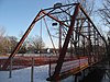 | 2007 | Tippecanoe River Rest Park, along Old U.S. Route 30/Lincoln Highway at County Road 350W near Warsaw 41°14′50″N 85°54′39″W / 41.24722°N 85.91083°W / 41.24722; -85.91083 (Chinworth Bridge) | Transportation; Buildings and Architecture |
See also
- List of Indiana state historical markers
- National Register of Historic Places listings in Kosciusko County, Indiana
References
- ^ "Indiana Historical Markers by County". State of Indiana. Retrieved 2012-03-15.
- ^ Papakeechie's Reserve, Indiana Historical Bureau, n.d. Accessed 2012-03-14.
- ^ Indian Hill, Indiana Historical Bureau, n.d. Accessed 2012-03-14.
- ^ Indiana's Glacier Lakes, Indiana Historical Bureau, n.d. Accessed 2012-03-14.
- ^ Continental Divide, Indiana Historical Bureau, n.d. Accessed 2012-03-14.
- ^ Site of Cowen Grove Seminary, 1851-1876, Indiana Historical Bureau, n.d. Accessed 2012-03-14.
- ^ Lawrence D. Bell, Indiana Historical Bureau, n.d. Accessed 2012-03-14.
- ^ Kosciusko County Jail, Indiana Historical Bureau, n.d. Accessed 2012-03-14.
- ^ Chinworth Bridge, Indiana Historical Bureau, n.d. Accessed 2012-03-14.
Wikimedia Commons has media related to Historical markers in Kosciusko County, Indiana.
External links
- Indiana Historical Marker Program
- Indiana Historical Bureau
- v
- t
- e
Municipalities and communities of Kosciusko County, Indiana, United States
County seat: Warsaw

communities
- Atwood
- Bayfield
- Bell Rohr Park
- Buttermilk Point
- Cedar Point
- Clunette
- Forest Glen
- Gravelton‡
- Hastings
- Highbanks
- Highlands Park
- Island Park
- Kanata Manayunk
- Kinsey
- Lakeside Park
- Lakeview Spring
- Milford Junction
- Monoquet
- Oakwood Park
- Packerton
- Pickwick Park
- Potawatomi Park
- Redmon Park
- Sevastopol
- Shady Banks
- South Park
- Stony Ridge
- Vawter Park
- Wawasee
- Wawasee Village
‡This populated place also has portions in an adjacent county or counties
- Indiana portal
- United States portal


