List of National Historic Landmarks in Pennsylvania
This is a List of National Historic Landmarks in Pennsylvania. There are 169 in the state. Listed in the tables below are the 102 NHLs outside Philadelphia. For the 67 within Philadelphia, see List of National Historic Landmarks in Philadelphia.
Three of these sites are shared with other states and are credited by the National Park Service as being located in those other states: the Delaware and Hudson Canal (centered in New York but extending into Pennsylvania); the Beginning Point of the U.S. Public Land Survey (on the Ohio–Pennsylvania border); and the Minisink Archeological Site, on the New Jersey-Pennsylvania border.
National Historic Landmarks in Pennsylvania (excluding Philadelphia)
Map all coordinates using OpenStreetMap
Download coordinates as:
- KML
- GPX (all coordinates)
- GPX (primary coordinates)
- GPX (secondary coordinates)
Following are National Historic Landmarks in Pennsylvania, but outside Philadelphia. For consistency, the National Historic Landmark name is used to label each one.
| [1] | Landmark name | Image | Date designated[2] | Location | County | Description |
|---|---|---|---|---|---|---|
| 1 | 1762 Waterworks |  | May 29, 1981 (#72001142) | Bethlehem 40°37′09″N 75°23′00″W / 40.619167°N 75.383333°W / 40.619167; -75.383333 (1762 Waterworks) | Northampton | The oldest municipal waterworks in the nation. |
| 2 | Edward G. Acheson House | 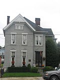 | May 11, 1976 (#76001679) | Monongahela 908 Main Street 40°12′20″N 79°56′02″W / 40.205638°N 79.933776°W / 40.205638; -79.933776 (Edward G. Acheson House) | Washington | Home of self-taught inventor-engineer Edward G. Acheson, where in 1891 he invented carborundum. |
| 3 | Allegheny County Courthouse and Jail |  | May 11, 1976 (#73001586) | Pittsburgh 436 Grant Street 40°26′18″N 79°59′46″W / 40.4384°N 79.9961°W / 40.4384; -79.9961 (Allegheny County Courthouse and Jail) | Allegheny | Spectacular jail and courthouse designed by architect Henry Hobson Richardson in a Romanesque style. |
| 4 | Allegheny Portage Railroad of the Pennsylvania Canal | 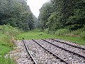 | December 29, 1962 (#66000648) | Johnstown 40°27′15″N 78°32′25″W / 40.454167°N 78.540278°W / 40.454167; -78.540278 (Allegheny Portage Railroad of the Pennsylvania Canal) | Blair | Railroad that transported canalboats over the Allegheny Mountains, between the eastern and western sections of the Pennsylvania Canal; regarded as a technological marvel. |
| 5 | Andalusia |  | November 13, 1966 (#66000649) | Andalusia 40°03′43″N 74°57′30″W / 40.061944°N 74.958333°W / 40.061944; -74.958333 (Andalusia) | Bucks | Greek Revival residence of Nicholas Biddle, head of the Second Bank of the United States. |
| 6 | Henry Antes House | 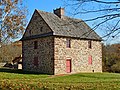 | April 27, 1992 (#75001657) | Pottstown 40°17′25″N 75°32′26″W / 40.290321°N 75.540558°W / 40.290321; -75.540558 (Henry Antes House) | Montgomery | Headquarters of George Washington, September 23 to 26, 1777.[3] |
| 7 | Augustus Lutheran Church |  | December 24, 1967 (#67000019) | Trappe 40°12′03″N 75°28′50″W / 40.200781°N 75.480545°W / 40.200781; -75.480545 (Augustus Lutheran Church) | Montgomery | |
| 8 | Bedford Springs Hotel Historic District |  | July 17, 1991 (#84001413) | Bedford 39°59′47″N 78°30′28″W / 39.996389°N 78.507778°W / 39.996389; -78.507778 (Bedford Springs Hotel Historic District) | Bedford | |
| 9 | Beginning Point of the U.S. Public Land Survey |  | June 23, 1965 (#66000606) | Ohioville, PA and East Liverpool, OH 40°38′26″N 80°31′10″W / 40.640487°N 80.519377°W / 40.640487; -80.519377 (Beginning Point of the U.S. Public Land Survey) | Beaver, PA and Columbiana, OH | |
| 10 | Beth Sholom Synagogue |  | March 29, 2007 (#07000430) | Elkins Park 8231 Old York Road 40°04′56″N 75°07′36″W / 40.082222°N 75.126667°W / 40.082222; -75.126667 (Beth Sholom Synagogue) | Montgomery | Frank Lloyd Wright designed it. The American Institute of Architects and National Trust for Historic Preservation commented upon it. |
| 11 | Bomberger's Distillery |  | January 16, 1980 (#75001649) | Newmanstown 40°16′30″N 76°19′13″W / 40.275034°N 76.320199°W / 40.275034; -76.320199 (Bomberger's Distillery) | Lebanon | |
| 12 | Bost Building | 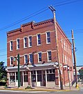 | January 20, 1999 (#99000627) | Homestead 621–623 East 8th Avenue 40°24′33″N 79°54′16″W / 40.40912°N 79.90436°W / 40.40912; -79.90436 (Bost Building) | Allegheny | Headquarters of the Amalgamated Association of Iron and Steel Workers during the Homestead Strike. |
| 13 | Braddock Carnegie Library | 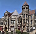 | March 2, 2012 (#73001585) | Braddock 40°24′07″N 79°51′56″W / 40.401869°N 79.865425°W / 40.401869; -79.865425 (Braddock Carnegie Library) | Allegheny | First Carnegie library built in the United States. |
| 14 | David Bradford House |  | July 28, 1983 (#73001668) | Washington 175 South Main Street 40°10′06″N 80°14′41″W / 40.168201°N 80.244776°W / 40.168201; -80.244776 (David Bradford House) | Washington | A home of David Bradford. |
| 15 | Brandywine Battlefield |  | January 20, 1961 (#66000660) | Chadds Ford 39°52′31″N 75°34′31″W / 39.875278°N 75.575278°W / 39.875278; -75.575278 (Brandywine Battlefield) | Delaware | Site of the 1777 Battle of Brandywine. |
| 16 | William Brinton 1704 House |  | December 24, 1967 (#67000018) | Dilworthtown 39°53′40″N 75°33′40″W / 39.894424°N 75.560993°W / 39.894424; -75.560993 (William Brinton 1704 House) | Delaware | |
| 17 | Bryn Athyn Historic District |  | October 6, 2008 (#08001087) | Bryn Athyn 40°08′04″N 75°03′48″W / 40.134444°N 75.063333°W / 40.134444; -75.063333 (Bryn Athyn Historic District) | Montgomery | |
| 18 | James Buchanan House (Wheatland) |  | July 4, 1961 (#66000669) | Lancaster 40°02′37″N 76°19′45″W / 40.043584°N 76.329183°W / 40.043584; -76.329183 (James Buchanan House (Wheatland)) | Lancaster | Home of James Buchanan while he was President and in his final years. |
| 19 | Pearl S. Buck House |  | January 16, 1980 (#74001755) | Perkasie 520 Dublin Road 40°21′36″N 75°13′11″W / 40.36°N 75.219722°W / 40.36; -75.219722 (Pearl S. Buck House) | Bucks | A home of author Pearl S. Buck. |
| 20 | Buckingham Friends Meeting House |  | July 31, 2003 (#97000291) | Buckingham Township 5684 Lower York Road 40°20′56″N 75°02′27″W / 40.348889°N 75.040833°W / 40.348889; -75.040833 (Buckingham Friends Meeting House) | Bucks | Associated with the Religious Society of Friends (Quakers). |
| 21 | Bushy Run Battlefield |  | October 9, 1960 (#66000696) | Harrison City 2 miles E. of Harrison City on PA Route 993 40°21′19″N 79°37′12″W / 40.355278°N 79.62°W / 40.355278; -79.62 (Bushy Run Battlefield) | Westmoreland | Site of the Battle of Bushy Run during Pontiac's Rebellion. |
| 22 | Cambria Iron Company |  | June 22, 1989 (#89001101) | Johnstown 40°20′10″N 78°55′23″W / 40.336°N 78.923°W / 40.336; -78.923 (Cambria Iron Company) | Cambria | |
| 23 | Simon Cameron House |  | May 15, 1975 (#73001620) | Harrisburg 219 South Front Street 40°15′23″N 76°52′45″W / 40.256523°N 76.879108°W / 40.256523; -76.879108 (Simon Cameron House) | Dauphin | A home of Simon Cameron who had some association under Abraham Lincoln. |
| 24 | Carlisle Indian School |  | July 4, 1961 (#66000658) | Carlisle 40°12′32″N 77°10′41″W / 40.209°N 77.178°W / 40.209; -77.178 (Carlisle Indian School) | Cumberland | Associated with Native American education. Athlete Jim Thorpe attended. |
| 25 | Carrie Blast Furnaces 6 and 7 | 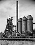 | September 20, 2006 (#06001070) | Rankin, Munhall, and Swissvale boroughs Northern side of the Monongahela River, 0.5 miles (0.80 km) west of the Rankin Bridge 40°24′47″N 79°53′24″W / 40.413081°N 79.89008°W / 40.413081; -79.89008 (Carrie Blast Furnaces 6 and 7) | Allegheny | The only 2 surviving pre-World War II blast furnaces in the Pittsburgh area. |
| 26 | Cedarcroft |  | November 11, 1971 (#71000693) | Kennett Square 39°51′28″N 75°43′09″W / 39.857827°N 75.719175°W / 39.857827; -75.719175 (Cedarcroft) | Chester | |
| 27 | Chatham Village |  | April 5, 2005 (#98001372) | Pittsburgh Roughly bounded by Virginia Avenue, Bigham Street, Woodruff Street, Saw Mill Run Boulevard, and Olympia Road 40°25′52″N 80°01′01″W / 40.4311°N 80.0169°W / 40.4311; -80.0169 (Chatham Village) | Allegheny | |
| 28 | Cornwall Iron Furnace |  | November 3, 1966 (#66000671) | Cornwall Rexmont Road & Boyd Street 40°16′14″N 76°24′22″W / 40.270556°N 76.406111°W / 40.270556; -76.406111 (Cornwall Iron Furnace) | Lebanon | |
| 29 | Delaware Canal |  | December 8, 1976 (#74001756) | Easton to Bristol Easton to Bristol along the Delaware River 40°05′36″N 74°51′41″W / 40.093283°N 74.861456°W / 40.093283; -74.861456 (Delaware Canal) | Bucks and Northampton | Transported anthracite coal. |
| 30 | Delaware and Hudson Canal |  | October 18, 1968 (#68000051) | Lackawaxen, PA, Honesdale, PA, Kingston, NY, Rosendale, NY, Ellenville, NY, and Port Jervis, NY 41°36′26″N 74°26′53″W / 41.607222°N 74.448056°W / 41.607222; -74.448056 (Delaware and Hudson Canal) | Pike, PA, Wayne, PA, Orange, NY, Sullivan, NY, and Ulster, NY | |
| 31 | Drake Oil Well |  | November 13, 1966 (#66000695) | Titusville 41°36′39″N 79°39′28″W / 41.6108°N 79.65769°W / 41.6108; -79.65769 (Drake Oil Well) | Venango | Edwin L. Drake struck oil here, the site of the world's first successful oil well. |
| 32 | East Broad Top Railroad | 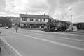 | January 28, 1964 (#66000666) | Rockhill 40°14′29″N 77°53′56″W / 40.241389°N 77.898889°W / 40.241389; -77.898889 (East Broad Top Railroad) | Huntingdon | |
| 33 | Dwight D. Eisenhower Farmstead |  | May 23, 1966 (#67000017) | Gettysburg 39°47′36″N 77°15′48″W / 39.793333°N 77.263333°W / 39.793333; -77.263333 (Dwight D. Eisenhower Farmstead) | Adams | A home of Dwight Eisenhower. |
| 34 | Emmanuel Episcopal Church |  | February 16, 2000 (#74001737) | Pittsburgh North and Allegheny Avenues 40°27′11″N 80°01′09″W / 40.45306°N 80.0192°W / 40.45306; -80.0192 (Emmanuel Episcopal Church) | Allegheny | |
| 35 | Ephrata Cloister |  | December 24, 1967 (#67000026) | Ephrata 40°10′59″N 76°11′21″W / 40.183056°N 76.189167°W / 40.183056; -76.189167 (Ephrata Cloister) | Lancaster | |
| 36 | Wharton Esherick House and Studio |  | April 19, 1993 (#73001615) | Malvern 40°05′02″N 75°29′38″W / 40.083808°N 75.493943°W / 40.083808; -75.493943 (Wharton Esherick House and Studio) | Chester | Studio of Wharton Esherick who participated in the Arts and Crafts Movement. |
| 37 | David Espy House |  | July 28, 1983 (#74001750) | Bedford 40°01′09″N 78°30′11″W / 40.019176°N 78.502980°W / 40.019176; -78.502980 (David Espy House) | Bedford | Associated with Whiskey Rebellion and David Espy. |
| 38 | Fallingwater | 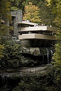 | May 11, 1976 (#74001781) | Mill Run 39°54′17″N 79°28′05″W / 39.904808°N 79.468120°W / 39.904808; -79.468120 (Fallingwater) | Fayette | Designed by Frank Lloyd Wright. |
| 39 | Fonthill, Mercer Museum and Moravian Pottery and Tile Works |  | February 4, 1985 (#85002366) | Doylestown 40°19′23″N 75°07′25″W / 40.323056°N 75.123611°W / 40.323056; -75.123611 (Fonthill, Mercer Museum and Moravian Pottery and Tile Works) | Bucks | Three sites associated with Henry Chapman Mercer. |
| 40 | Forks of the Ohio |  | October 9, 1960 (#66000643) | Pittsburgh Point Park 40°26′27″N 80°00′37″W / 40.4408°N 80.01028°W / 40.4408; -80.01028 (Forks of the Ohio) | Allegheny | Associated with French and Indian War. |
| 41 | Fulton Opera House |  | January 29, 1964 (#69000156) | Lancaster 12–14 North Prince Street 40°02′17″N 76°18′28″W / 40.038156°N 76.307877°W / 40.038156; -76.307877 (Fulton Opera House) | Lancaster | Named for Robert Fulton, it is one of the oldest continuously-operated theaters. |
| 42 | Robert Fulton Birthplace |  | January 29, 1964 (#66000670) | Quarryville 8 miles south of Quarryville on U.S. Route 22 39°48′17″N 76°09′37″W / 39.804722°N 76.160278°W / 39.804722; -76.160278 (Robert Fulton Birthplace) | Lancaster | Also associated with Robert Fulton. |
| 43 | Albert Gallatin House |  | January 12, 1965 (#66000663) | Point Marion 39°46′40″N 79°55′45″W / 39.777778°N 79.929168°W / 39.777778; -79.929168 (Albert Gallatin House) | Fayette | A home of Albert Gallatin. |
| 44 | Gemeinhaus-Lewis David de Schweinitz Residence |  | May 15, 1975 (#75001658) | Bethlehem 40°37′00″N 75°22′52″W / 40.616805°N 75.381147°W / 40.616805; -75.381147 (Gemeinhaus-Lewis David de Schweinitz Residence) | Northampton | A home of botanist Lewis David de Schweinitz. |
| 45 | Graeme Park |  | October 9, 1960 (#66000672) | Horsham 40°13′00″N 75°09′00″W / 40.216667°N 75.15°W / 40.216667; -75.15 (Graeme Park) | Montgomery | |
| 46 | Grey Towers |  | February 4, 1985 (#80003578) | Glenside 40°04′46″N 75°09′54″W / 40.079554°N 75.165082°W / 40.079554; -75.165082 (Grey Towers) | Montgomery | Designed by Horace Trumbauer. Now part of Arcadia University. |
| 47 | Gruber Wagon Works |  | December 22, 1977 (#72001092) | Reading 40°22′14″N 75°58′47″W / 40.3706°N 75.9796°W / 40.3706; -75.9796 (Gruber Wagon Works) | Berks | Located in what is now Tulpehocken Creek Park. |
| 48 | Historic Moravian Bethlehem District |  | October 16, 2012 (#12001016) | Bethlehem 40°37′08″N 75°22′51″W / 40.618924°N 75.38076°W / 40.618924; -75.38076 (Historic Moravian Bethlehem District) | Northampton | |
| 49 | I. N. and Bernardine Hagan House |  | May 16, 2000 (#00000708) | Chalk Hill 39°52′09″N 79°31′11″W / 39.869167°N 79.519722°W / 39.869167; -79.519722 (I. N. and Bernardine Hagan House) | Fayette | A higher end Usonian house of those designed by Frank Lloyd Wright. |
| 50 | Harmony Historic District |  | May 30, 1974 (#73002139) | Harmony 40°48′11″N 80°07′42″W / 40.803056°N 80.128333°W / 40.803056; -80.128333 (Harmony Historic District) | Butler | Associated with Harmony Society and George Rapp. |
| 51 | Harrisburg Station and Trainshed |  | December 8, 1976 (#75001638) | Harrisburg 40°15′36″N 76°52′40″W / 40.260120°N 76.877761°W / 40.260120; -76.877761 (Harrisburg Station and Trainshed) | Dauphin | Pennsylvania Railroad station with sheds using truss system patented by Albert Fink. |
| 52 | Milton S. Hershey Mansion |  | May 4, 1983 (#78002388) | Hershey Mansion Road 40°17′18″N 76°38′39″W / 40.288271°N 76.644087°W / 40.288271; -76.644087 (Milton S. Hershey Mansion) | Dauphin | A home of Milton Snavely Hershey. |
| 53 | Honey Hollow Watershed |  | August 4, 1969 (#69000155) | New Hope 40°22′26″N 75°00′27″W / 40.373889°N 75.0075°W / 40.373889; -75.0075 (Honey Hollow Watershed) | Bucks | |
| 54 | Horseshoe Curve |  | November 13, 1966 (#66000647) | Altoona 40°29′45″N 78°28′54″W / 40.495753°N 78.481696°W / 40.495753; -78.481696 (Horseshoe Curve) | Blair | A horseshoe-shaped railroad track |
| 55 | Keim Homestead |  | December 23, 2016 (#100000832) | Pike Township 40°24′35″N 75°44′54″W / 40.409722°N 75.748333°W / 40.409722; -75.748333 (Keim Homestead) | Berks | |
| 56 | Kennywood Park | 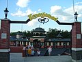 | February 27, 1987 (#87000824) | West Mifflin 4800 Kennywood Boulevard 40°23′15″N 79°51′48″W / 40.3875°N 79.8633°W / 40.3875; -79.8633 (Kennywood Park) | Allegheny | From trolley park era, One of America's first amusement parks. |
| 57 | Leap-The-Dips |  | June 19, 1996 (#91000229) | Altoona 700 Park Avenue 40°28′15″N 78°23′48″W / 40.470833°N 78.396667°W / 40.470833; -78.396667 (Leap-The-Dips) | Blair | The oldest wooden rollercoaster still standing in the United States. |
| 58 | F. Julius Lemoyne House |  | September 25, 1997 (#97001271) | Washington 49 East Maiden Street 40°10′05″N 80°14′35″W / 40.168064°N 80.243168°W / 40.168064; -80.243168 (F. Julius Lemoyne House) | Washington | A home of F. Julius LeMoyne, involved with the Underground Railroad |
| 59 | Lightfoot Mill |  | April 5, 2005 (#73001616) | Chester Springs 40°04′53″N 75°38′40″W / 40.081389°N 75.644444°W / 40.081389; -75.644444 (Lightfoot Mill) | Chester | See also Oliver Evans. |
| 60 | Lukens Historic District |  | April 19, 1994 (#94001186) | Coatesville 50, 53, 76 & 102 South First Street 39°58′52″N 75°49′21″W / 39.981111°N 75.8225°W / 39.981111; -75.8225 (Lukens Historic District) | Chester | Associated with Rebecca Lukens and Brandywine Ironworks (later Lukens Steel Company). |
| 61 | Humphry Marshall House |  | December 23, 1987 (#87002596) | Marshallton 1407 South Strasburg Road/PA Route 162 39°56′52″N 75°40′53″W / 39.947747°N 75.681474°W / 39.947747; -75.681474 (Humphry Marshall House) | Chester | A home of Humphry Marshall. |
| 62 | Meadowcroft Rockshelter |  | April 5, 2005 (#78002480) | West of Avella 40°17′11″N 80°29′30″W / 40.286389°N 80.491667°W / 40.286389; -80.491667 (Meadowcroft Rockshelter) | Washington | Archaeological site associated with Native Americans. |
| 63 | Isaac Meason House |  | June 21, 1990 (#71000707) | Mount Braddock 39°57′14″N 79°38′53″W / 39.953946°N 79.648189°W / 39.953946; -79.648189 (Isaac Meason House) | Fayette | A home of Isaac Meason. |
| 64 | Merion Cricket Club |  | February 27, 1987 (#87000759) | Haverford 40°00′56″N 75°18′01″W / 40.015596°N 75.300360°W / 40.015596; -75.300360 (Merion Cricket Club) | Montgomery | From when cricket competed with baseball for American attention. |
| 65 | Merion Friends Meeting House |  | August 5, 1998 (#98001194) | Merion Station 40°00′32″N 75°15′11″W / 40.008786°N 75.252977°W / 40.008786; -75.252977 (Merion Friends Meeting House) | Montgomery | |
| 66 | Merion Golf Club |  | April 27, 1992 (#89002085) | Ardmore 39°59′36″N 75°19′35″W / 39.993333°N 75.326389°W / 39.993333; -75.326389 (Merion Golf Club) | Delaware | Associated with Bobby Jones, who won the Grand Slam of Golf here in 1930. Host of many U.S. Opens. |
| 67 | Mill Grove |  | May 5, 1989 (#72001138) | Audubon 40°07′23″N 75°26′39″W / 40.123056°N 75.444167°W / 40.123056; -75.444167 (Mill Grove) | Montgomery | A home of John James Audubon. |
| 68 | Minisink Archeological Site |  | April 19, 1993 (#93000608) | Bushkill 41°17′26″N 74°49′44″W / 41.2906°N 74.829°W / 41.2906; -74.829 (Minisink Archeological Site) | Pike | Prehistoric native site; extends into New Jersey. |
| 69 | George Nakashima Woodworker Complex |  | April 23, 2014 (#08000782) | Solebury Township 40°20′25″N 74°57′20″W / 40.3402°N 74.9556°W / 40.3402; -74.9556 (George Nakashima Woodworker Complex) | Bucks | Art studio and home of woodworker George Nakashima |
| 70 | Oakmont Country Club |  | June 30, 1987 (#84003090) | Oakmont 40°31′33″N 79°49′36″W / 40.525758°N 79.826764°W / 40.525758; -79.826764 (Oakmont Country Club) | Allegheny | Built 1903, one of the first top-caliber golf courses anywhere. |
| 71 | Old Economy |  | June 23, 1965 (#66000644) | Ambridge 40°35′46″N 80°13′59″W / 40.596158°N 80.233001°W / 40.596158; -80.233001 (Old Economy) | Beaver | Associated with Harmony Society and George Rapp. |
| 72 | Old West, Dickinson College |  | June 13, 1962 (#66000659) | Carlisle 40°12′10″N 77°11′42″W / 40.2029°N 77.1951°W / 40.2029; -77.1951 (Old West, Dickinson College) | Cumberland | Designed by Benjamin H. Latrobe, part of Dickinson College which was founded by Benjamin Rush. James Buchanan, later president, lived here. |
| 73 | Asa Packer Mansion |  | February 4, 1985 (#74001765) | Jim Thorpe 40°51′52″N 75°44′18″W / 40.864427°N 75.738389°W / 40.864427; -75.738389 (Asa Packer Mansion) | Carbon | Designed by Samuel Sloan, home of Asa Packer, founder of the Lehigh Valley Railroad and Lehigh University. |
| 74 | Pennsylvania State Capitol Complex |  | September 20, 2006 (#77001162) | Harrisburg Bounded by 3rd and 7th, North and Walnut Streets 40°15′52″N 76°53′01″W / 40.264441°N 76.883624°W / 40.264441; -76.883624 (Pennsylvania State Capitol Complex) | Dauphin | Includes the Pennsylvania State Capitol, North and South Office Buildings, Finance Building, Forum Building, State Street Bridge and Ryan Legislative Office Building. Originally listed with only the capitol, expanded in 2013 to encompass surrounding buildings. |
| 75 | Gifford Pinchot House |  | May 23, 1963 (#66000694) | Milford 41°19′39″N 74°49′15″W / 41.3275°N 74.820833°W / 41.3275; -74.820833 (Gifford Pinchot House) | Pike | Home of Gifford Pinchot, first head of the U.S. Forest Service and two-time state governor. |
| 76 | Terence V. Powderly House |  | May 23, 1966 (#66000667) | Scranton 41°25′06″N 75°40′29″W / 41.418413°N 75.674728°W / 41.418413; -75.674728 (Terence V. Powderly House) | Lackawanna | Longtime home of Terence Vincent Powderly, a Knights of Labor leader. |
| 77 | Joseph Priestley House |  | January 12, 1965 (#66000673) | Northumberland 40°53′17″N 76°47′25″W / 40.888028°N 76.790359°W / 40.888028; -76.790359 (Joseph Priestley House) | Northumberland | Stately home of chemist Joseph Priestley, who, disenchanted with England moved here in 1794 and continued his ground-breaking research. |
| 78 | The Printzhof |  | November 5, 1961 (#66000661) | Essington 39°51′33″N 75°18′11″W / 39.859164°N 75.303151°W / 39.859164; -75.303151 (The Printzhof) | Delaware | A home of Johan Printz. |
| 79 | Pulpit Rocks |  | November 4, 1993 (#93001614) | Huntingdon 40°31′09″N 78°02′43″W / 40.519167°N 78.045278°W / 40.519167; -78.045278 (Pulpit Rocks) | Huntingdon | |
| 80 | Matthew S. Quay House |  | May 15, 1975 (#75001615) | Beaver 40°41′38″N 80°18′12″W / 40.693766°N 80.303372°W / 40.693766; -80.303372 (Matthew S. Quay House) | Beaver | A home of Matthew Stanley Quay, a Republican National Chairman who was campaign manager for Benjamin Harrison's successful presidential campaign. |
| 81 | St. Mark's Episcopal Church (Jim Thorpe) |  | December 23, 1987 (#77001135) | Jim Thorpe 40°51′47″N 75°44′18″W / 40.863018°N 75.738209°W / 40.863018; -75.738209 (St. Mark's Episcopal Church (Jim Thorpe)) | Carbon | |
| 82 | Searights Tollhouse, National Road |  | January 29, 1964 (#66000665) | Uniontown 39°56′43″N 79°47′40″W / 39.945285°N 79.794553°W / 39.945285; -79.794553 (Searights Tollhouse, National Road) | Fayette | Tollhouses built in 1835 as part of the National Road. |
| 83 | Schaeffer House |  | July 25, 2011 (#11000630) | Schaefferstown 40°17′47″N 76°18′01″W / 40.296297°N 76.300257°W / 40.296297; -76.300257 (Schaeffer House) | Lebanon | Possibly the only remaining German Weinbauernhaus in America, combining a residence with the production of alcohol.[4] |
| 84 | Smithfield Street Bridge |  | May 11, 1976 (#74001745) | Pittsburgh Smithfield Street at the Monongahela River 40°26′05″N 80°00′08″W / 40.4347°N 80.0022°W / 40.4347; -80.0022 (Smithfield Street Bridge) | Allegheny | A truss bridge built between 1881 and 1883. |
| 85 | Staple Bend Tunnel | 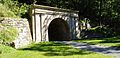 | April 19, 1994 (#94001187) | Conemaugh Township 40°21′26″N 78°51′19″W / 40.357273°N 78.855303°W / 40.357273; -78.855303 (Staple Bend Tunnel) | Cambria | The first railroad tunnel in the United States. Regarded as an engineering marvel. |
| 86 | Stiegel-Coleman House |  | November 13, 1966 (#66000668) | Brickerville 40°14′16″N 76°17′48″W / 40.2378°N 76.2968°W / 40.2378; -76.2968 (Stiegel-Coleman House) | Lancaster | House built in parts by owner William Stiegel and then by Robert Coleman. |
| 87 | Summerseat |  | July 17, 1965 (#71000685) | Morrisville 40°12′27″N 74°46′44″W / 40.207449°N 74.778895°W / 40.207449; -74.778895 (Summerseat) | Bucks | A home of George Clymer, a signer of the Declaration of Independence and the U.S. Constitution. |
| 88 | George Taylor House |  | July 17, 1971 (#71000709) | Catasauqua Lehigh & Poplar Streets 40°38′45″N 75°27′59″W / 40.64587°N 75.466398°W / 40.64587; -75.466398 (George Taylor House) | Lehigh | A home of George Taylor, a signer of the Declaration of Independence. |
| 89 | M. Carey Thomas Library |  | July 17, 1991 (#91002052) | Bryn Mawr 40°01′37″N 75°18′50″W / 40.026821°N 75.313855°W / 40.026821; -75.313855 (M. Carey Thomas Library) | Montgomery | An architecturally significant building on Bryn Mawr College campus. |
| 90 | Union Canal Tunnel |  | April 19, 1994 (#74001792) | Lebanon Tunnel Hill Road 40°20′58″N 76°27′42″W / 40.349444°N 76.461667°W / 40.349444; -76.461667 (Union Canal Tunnel) | Lebanon | |
| 91 | Valley Forge | 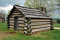 | January 20, 1961 (#66000657) | Valley Forge 40°05′49″N 75°26′20″W / 40.096944°N 75.438889°W / 40.096944; -75.438889 (Valley Forge) | Chester and Montgomery | |
| 92 | Gen. Friedrich Von Steuben Headquarters | 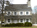 | November 28, 1972 (#72001108) | Valley Forge National Historical Park 40°05′49″N 75°28′13″W / 40.096988°N 75.470278°W / 40.096988; -75.470278 (Gen. Friedrich Von Steuben Headquarters) | Chester | Headquarters of drillmaster Baron Friedrich Wilhelm Ludolf Gerhard Augustin von Steuben who had served Frederick the Great. Now part of Valley Forge National Historical Park. |
| 93 | Washington's Crossing |  | January 20, 1961 (#66000650) | Yardley, PA and Titusville, NJ 40°17′51″N 74°52′35″W / 40.2975°N 74.876389°W / 40.2975; -74.876389 (Washington's Crossing) | Bucks, PA and Mercer County, NJ | Pennsylvania location of George Washington's crossing of the Delaware River leading up to the Battle of Trenton on December 26, 1776, includes Washington Crossing State Park in New Jersey |
| 94 | Washington's Headquarters |  | November 28, 1972 (#73001655) | Valley Forge National Historical Park Valley Creek Road, near junction of PA Routes 252 & 23 40°05′58″N 75°27′43″W / 40.099490°N 75.461954°W / 40.099490; -75.461954 (Washington's Headquarters) | Montgomery | Part of Valley Forge National Historical Park. |
| 95 | Waynesborough |  | November 28, 1972 (#73001603) | Paoli 40°01′55″N 75°28′23″W / 40.031988°N 75.473145°W / 40.031988; -75.473145 (Waynesborough) | Chester | Home of General Anthony Wayne. |
| 96 | Conrad Weiser House |  | October 9, 1960 (#66000646) | Womelsdorf 40°21′33″N 76°10′26″W / 40.359167°N 76.173889°W / 40.359167; -76.173889 (Conrad Weiser House) | Berks | A home of Johann Conrad Weiser, who enlisted the Iroquois on the British side of the French and Indian War. |
| 97 | Benjamin West Birthplace |  | December 21, 1965 (#66000662) | Swarthmore 39°54′18″N 75°21′05″W / 39.905095°N 75.351400°W / 39.905095; -75.351400 (Benjamin West Birthplace) | Delaware | Birthplace of Benjamin West who supported artists including Gilbert Stuart and Charles Willson Peale. On campus of Swarthmore College. |
| 98 | Woodmont | 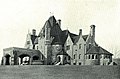 | August 5, 1998 (#98001192) | Gladwyne 1622 Spring Mill Road 40°03′48″N 75°17′29″W / 40.0634°N 75.2915°W / 40.0634; -75.2915 (Woodmont) | Montgomery | Designed by William Lightfoot Price for industrialist Alan Wood, Jr. Father Divine also lived here. |
| 99 | Woodville |  | July 28, 1983 (#74001733) | Heidelberg South of Heidelberg on Pennsylvania Route 50 40°22′47″N 80°05′47″W / 40.3797°N 80.0964°W / 40.3797; -80.0964 (Woodville) | Allegheny | Home of John Neville, tax collector during the Whiskey Rebellion of 1794. |
| 100 | Andrew Wyeth Studio and Kuerner Farm |  | June 23, 2011 (#11000564) | Chadds Ford Township 39°52′09″N 75°34′32″W / 39.8692°N 75.5756°W / 39.8692; -75.5756 (Andrew Wyeth Studio and Kuerner Farm) | Delaware | The Kuerner Farm was the inspiration for more than 1,000 Wyeth paintings over a 64-year period. Listing expanded (and renamed) in 2014 to include the studio of Andrew Wyeth. |
| 101 | N. C. Wyeth House and Studio |  | December 9, 1997 (#97001680) | Chadds Ford Township 39°51′59″N 75°35′09″W / 39.866342°N 75.585785°W / 39.866342; -75.585785 (N. C. Wyeth House and Studio) | Delaware | Home and studio of painter N.C. Wyeth and family. Managed by the Brandywine River Museum. |
| 102 | W. A. Young and Sons Foundry and Machine Shop |  | December 23, 2016 (#100000839) | Rices Landing 39°56′59″N 79°59′57″W / 39.949679°N 79.999268°W / 39.949679; -79.999268 (W. A. Young and Sons Foundry and Machine Shop) | Greene |
See also
Wikimedia Commons has media related to National Historic Landmarks in Pennsylvania.
- National Register of Historic Places listings in Pennsylvania
- List of National Historic Landmarks by state
- List of National Historic Sites in United States
- List of Pennsylvania state historical markers
- List of National Natural Landmarks in Pennsylvania
References
- ^ Numbers represent an alphabetical ordering by significant words. Various colorings, defined here, differentiate National Historic Landmarks and historic districts from other NRHP buildings, structures, sites or objects.
- ^ The eight-digit number below each date is the number assigned to each location in the National Register Information System database, which can be viewed by clicking the number.
- ^ General Orders, 23 September 1777 from the National Archives.
- ^ http://www.doi.gov/news/pressreleases/AMERICAS-GREAT-OUTDOORS-Secretary-Salazar-Designates-Four-National-Historic-Landmarks.cfm NHL announcement
External links
Map all coordinates using OpenStreetMap
Download coordinates as:
- KML
- GPX (all coordinates)
- GPX (primary coordinates)
- GPX (secondary coordinates)
- "National Register Information System". National Register of Historic Places. National Park Service. July 9, 2010.
- Pennsylvania's Cultural Resources Geographic Information System
- Listings at NationalRegisterofHistoricalPlaces.com
- v
- t
- e
- Alabama
- Alaska
- Arizona
- Arkansas
- California
- Colorado
- Connecticut
- Delaware
- Florida
- Georgia
- Hawaii
- Idaho
- Illinois
- Indiana
- Iowa
- Kansas
- Kentucky
- Louisiana
- Maine
- Maryland
- Massachusetts
- Michigan
- Minnesota
- Mississippi
- Missouri
- Montana
- Nebraska
- Nevada
- New Hampshire
- New Jersey
- New Mexico
- New York
- North Carolina
- North Dakota
- Ohio
- Oklahoma
- Oregon
- Pennsylvania
- Rhode Island
- South Carolina
- South Dakota
- Tennessee
- Texas
- Utah
- Vermont
- Virginia
- Washington
- West Virginia
- Wisconsin
- Wyoming
| Insular area | |
|---|---|
| Associated state | |
| Foreign country |
| ||
|---|---|---|
| Topics |  | |
| Lists by county |
| |
| Lists by city | ||
| Other lists |
| |
| ||


