List of National Natural Landmarks in Tennessee
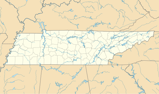
Map all coordinates using OpenStreetMap
Download coordinates as:
- KML
- GPX (all coordinates)
- GPX (primary coordinates)
- GPX (secondary coordinates)
From List of National Natural Landmarks, these are the National Natural Landmarks in Tennessee. There are 13 in total.

Big Bone Cave
The Lost Sea
Cumberland Caverns
Reelfoot Lake
Dick Cove
May Prairie
class=notpageimage|
Tennessee National Natural Landmarks (clickable map)| Name | Image | Date | Location | County | Ownership | Description | |
|---|---|---|---|---|---|---|---|
| 1 | Arnold Engineering Development Center Natural Areas | 1974 | Coffee | federal (Arnold Air Force Base) | Contains an extremely rare virgin swamp forest and a pristine example of an open marsh. | ||
| 2 | Big Bone Cave | 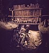 | 1973 | 35°46′21″N 85°33′25″W / 35.7726°N 85.557°W / 35.7726; -85.557 (Big Bone Cave) | Van Buren | state | Cave where giant ground sloth bones were discovered. |
| 3 | Cedar Glades | 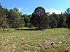 | 1973 | 36°04′25″N 86°18′41″W / 36.07366°N 86.31151°W / 36.07366; -86.31151 (Cedars of Lebanon State Park) | Wilson | state (Cedars of Lebanon State Park) | The largest and best remaining example of the cedar glade community. |
| 4 | Conley Hole | 1973 | Grundy | private | One of the most spectacular and outstanding examples of a pit cave in the United States. | ||
| 5 | Cumberland Caverns | 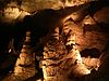 | 1973 | 35°40′09″N 85°40′51″W / 35.669167°N 85.680833°W / 35.669167; -85.680833 (Cumberland Caverns) | Warren | private | Two interconnecting caves at least 27 miles (43 km) in extent. |
| 6 | Dick Cove | 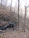 | 1973 | 35°13′40″N 85°57′19″W / 35.227839°N 85.955392°W / 35.227839; -85.955392 (Dick Cove) | Franklin | private | A near virgin forest |
| 7 | Grassy Cove Karst Area |  | 1973 | 35°51′24″N 84°55′35″W / 35.856787°N 84.926373°W / 35.856787; -84.926373 (Grassy Cove) | Cumberland | private | One of the nation's best illustrations of karst development and underground drainage |
| 8 | The Lost Sea | 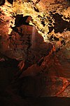 | 1974 | 35°32′08″N 84°25′52″W / 35.535556°N 84.431111°W / 35.535556; -84.431111 (Lost Sea) | Monroe | private | Cavern system that includes the largest known underground lake in the country. |
| 9 | May Prairie | 1974 | 35°27′01″N 86°01′20″W / 35.450232°N 86.022274°W / 35.450232; -86.022274 (May Prairie) | Coffee | state | Largest and best relict prairie remaining in Tennessee. | |
| 10 | McAnulty's Woods | 1973 | Hardeman | private | Only known example in western Tennessee of the upland forests of the Mississippi Embayment | ||
| 11 | Piney Falls | 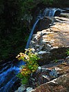 | 1974 | Rhea | state (Piney Falls State Natural Area) | Contains a rare virgin mixed mesophytic forest stand. | |
| 12 | Reelfoot Lake | 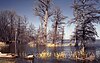 | 1966 | 36°23′20″N 89°23′20″W / 36.388889°N 89.388889°W / 36.388889; -89.388889 (Reelfoot Lake) | Lake, Obion | federal (Reelfoot National Wildlife Refuge) | Mosaic of habitats formed as a result of the New Madrid earthquake, |
| 13 | Savage Gulf |  | 1971 | 35°15′32″N 85°47′20″W / 35.259°N 85.789°W / 35.259; -85.789 (Savage Gulf) | Grundy | state (Savage Gulf State Natural Area) | A virgin forest. |
See also
- v
- t
- e
National Natural Landmarks in the United States
- Alabama
- Alaska
- Arizona
- Arkansas
- California
- Colorado
- Connecticut
- Delaware
- Florida
- Georgia
- Hawaii
- Idaho
- Illinois
- Indiana
- Iowa
- Kansas
- Kentucky
- Louisiana
- Maine
- Maryland
- Massachusetts
- Michigan
- Minnesota
- Mississippi
- Missouri
- Montana
- Nebraska
- Nevada
- New Hampshire
- New Jersey
- New Mexico
- New York
- North Carolina
- North Dakota
- Ohio
- Oklahoma
- Oregon
- Pennsylvania
- Rhode Island
- South Carolina
- South Dakota
- Tennessee
- Texas
- Utah
- Vermont
- Virginia
- Washington
- West Virginia
- Wisconsin
- Wyoming


