List of impact structures in Australia

Map all coordinates using OpenStreetMap
Download coordinates as:
- KML
- GPX (all coordinates)
- GPX (primary coordinates)
- GPX (secondary coordinates)
This list includes all 27 confirmed impact structures in Australia as listed in the Earth Impact Database.[1]
Impact structures - confirmed
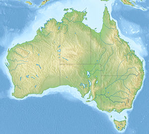


class=notpageimage|
Locations of confirmed impact craters in Australia, maximum ages: Cenozoic Mesozoic Paleozoic Precambrian| Name | State | Diameter (km) | Age (years) | Coordinates |
|---|---|---|---|---|
| Acraman | South Australia | 90 | about 590 million | 32°1′S 135°27′E / 32.017°S 135.450°E / -32.017; 135.450 (Acraman) |
| Amelia Creek | Northern Territory | 20 | 1660 - 600 million | 20°55′S 134°50′E / 20.917°S 134.833°E / -20.917; 134.833 (Amelia Creek) |
| Boxhole | Northern Territory | 0.17 | 5,400 ± 1,500 | 22°37′S 135°12′E / 22.617°S 135.200°E / -22.617; 135.200 (Boxhole) |
| Connolly Basin | Western Australia | 9 | < 60 million | 23°32′S 124°45′E / 23.533°S 124.750°E / -23.533; 124.750 (Connolly Basin) |
| Crawford | South Australia | 8.5 | > 35 million | 34°43′S 139°2′E / 34.717°S 139.033°E / -34.717; 139.033 (Crawford) |
| Dalgaranga | Western Australia | 0.02 | about 3000 | 27°38′S 117°17′E / 27.633°S 117.283°E / -27.633; 117.283 (Dalgaranga) |
| Flaxman | South Australia | 10 | > 35 million | 34°37′S 139°4′E / 34.617°S 139.067°E / -34.617; 139.067 (Flaxman) |
| Foelsche | Northern Territory | 6 | > 545 million | 16°40′S 136°47′E / 16.667°S 136.783°E / -16.667; 136.783 (Foelsche) |
| Glikson | Western Australia | 19 | < 508 million | 23°59′S 121°34′E / 23.983°S 121.567°E / -23.983; 121.567 (Glikson) |
| Goat Paddock | Western Australia | 5 | < 50 million | 18°20′S 126°40′E / 18.333°S 126.667°E / -18.333; 126.667 (Goat Paddock) |
| Gosses Bluff | Northern Territory | 22 | 142.5 ± 0.8 million | 23°49′S 132°19′E / 23.817°S 132.317°E / -23.817; 132.317 (Gosses Bluff) |
| Goyder | Northern Territory | 3 | < 1.4 billion | 13°9′S 135°2′E / 13.150°S 135.033°E / -13.150; 135.033 (Goyder) |
| Henbury | Northern Territory | 0.16 | 4200 ± 1900 | 24°34′S 133°09′E / 24.567°S 133.150°E / -24.567; 133.150 (Henbury) |
| Kelly West | Northern Territory | 10 | > 550 million | 19°56′S 133°57′E / 19.933°S 133.950°E / -19.933; 133.950 (Kelly West) |
| Lawn Hill | Queensland | 18 | > 515 million | 18°40′S 138°39′E / 18.667°S 138.650°E / -18.667; 138.650 (Lawn Hill) |
| Liverpool | Northern Territory | 1.6 | 1000 - 543 million | 12°24′S 134°3′E / 12.400°S 134.050°E / -12.400; 134.050 (Liverpool) |
| Matt Wilson | Northern Territory | 7.5 | < 1402 ± 440 million | 15°30′4″S 131°10′43″E / 15.50111°S 131.17861°E / -15.50111; 131.17861 (Wilson) |
| Mount Toondina | South Australia | 4 | < 110 million | 27°57′S 135°22′E / 27.950°S 135.367°E / -27.950; 135.367 (Mount Toondina) |
| Piccaninny | Western Australia | 7 | < 360 million | 17°26′S 128°26′E / 17.433°S 128.433°E / -17.433; 128.433 (Piccaninny) |
| Shoemaker (formerly Teague) | Western Australia | 30 | Proterozoic | 25°52′S 120°53′E / 25.867°S 120.883°E / -25.867; 120.883 (Shoemaker) |
| Spider | Western Australia | 13 | > 570 million | 16°44′S 126°5′E / 16.733°S 126.083°E / -16.733; 126.083 (Spider) |
| Strangways | Northern Territory | 25 | 646 ± 42 million | 15°12′S 133°35′E / 15.200°S 133.583°E / -15.200; 133.583 (Strangways) |
| Tookoonooka | Queensland | 55 | 128 ± 5 million | 27°7′S 142°50′E / 27.117°S 142.833°E / -27.117; 142.833 (Tookoonooka) |
| Veevers | Western Australia | 0.08 | < 20 thousand | 22°58′S 125°22′E / 22.967°S 125.367°E / -22.967; 125.367 (Veevers) |
| Wolfe Creek | Western Australia | 0.87 | 120,000 | 19°10′S 127°48′E / 19.167°S 127.800°E / -19.167; 127.800 (Wolfe Creek) |
| Woodleigh | Western Australia | 60–120 | 364 ± 8 million | 26°3′S 114°40′E / 26.050°S 114.667°E / -26.050; 114.667 (Woodleigh) |
| Yarrabubba[2] | Western Australia | 70 | > 2 billion | 27°10′S 118°50′E / 27.167°S 118.833°E / -27.167; 118.833 (Yarrabubba) |
| Ora Banda | Western Australia | 5 | 100 million | 30°38′S 121°06′E / 30.633°S 121.100°E / -30.633; 121.100 (Ora Banda) |
| Hickman Crater | Newman, Western Australia | 0.27 | 10 - 100 thousand | 23°2′13.4″S 119°40′59.3″E / 23.037056°S 119.683139°E / -23.037056; 119.683139 (Hickman Crater) |
| Yallalie Impact Structure | Dandaragan, Western Australia | 12 | 80-90 Million | 30°27′05″S 115°46′57″E / 30.45139°S 115.78250°E / -30.45139; 115.78250 (Yallalie Crater) |
Unconfirmed impact structures
The following structures are officially considered "unconfirmed" because they are not listed in the Earth Impact Database. Due to stringent requirements regarding evidence and peer-reviewed publication, newly discovered craters or those with difficulty collecting evidence generally are known for some time before becoming listed. However, entries on the unconfirmed list could still have an impact origin disproven.
| Name | State | Diameter (km) | Age | Coordinates |
|---|---|---|---|---|
| Bedout[3][4] | Indian Ocean, Western Australia | 200 | 250 million | 18°S 119°E / 18°S 119°E / -18; 119 (Bedout) |
| Darwin Crater[5] | Tasmania | 1.2 | 800 thousand | 42°19′S 145°40′E / 42.317°S 145.667°E / -42.317; 145.667 (Darwin crater) |
| Deniliquin multiple-ring feature[6] | Southeast Australia | 520 | 445-444 million, Hirnantian mass extinction event[7] | 35°32′0″S 144°58′0″E / 35.53333°S 144.96667°E / -35.53333; 144.96667 (Deniliquin) |
| Diamantina River ring feature[8][9] | Upper Diamantina River, Queensland | 130 | 300 million | 22°09′S 141°54′E / 22.15°S 141.9°E / -22.15; 141.9 (?) |
| East Warburton Basin[10] | South Australia | 200 [11] | about 300-360 million | 27°0′S 140°5′E / 27.000°S 140.083°E / -27.000; 140.083 (East Warburton Basin) |
| West Warburton Basin[12] | South Australia | 200 [11] | about 300-360 million | |
| Gnargoo[13] | Carnarvon Basin, Western Australia | 75 | <300 | 24°48′24″S 115°13′29″E / 24.80667°S 115.22472°E / -24.80667; 115.22472 (Gnargoo) |
See also
- Impact craters
- Impact events
- Bolides and Meteorites
- Earth Impact Database – primary source
- Traces of Catastrophe book from Lunar and Planetary Institute - comprehensive reference on impact crater science
Notes
- ^ Bevan, Alex. and Ken McNamara (2009) Australia's meteorite craters Welshpool, W. A. : Western Australian Museum, 2nd ed. ISBN 978-1-920843-96-0 (pbk.) and other sources provide a contrast in methodology and limitations to the information in the EID
- ^ Erickson, Timmons M.; Kirkland, Christopher L.; Timms, Nicholas E.; Cavosie, Aaron J.; Davison, Thomas M. (2020). "Precise radiometric age establishes Yarrabubba, Western Australia, as Earth's oldest recognised meteorite impact structure". Nature Communications. 11 (1): 300. Bibcode:2020NatCo..11..300E. doi:10.1038/s41467-019-13985-7. PMC 6974607. PMID 31964860.
- ^ Becker, L., Poreda, R.J., Basu, A.R., Pope, K.O., Harrison, T.M., Nicholson, C., and Iasky, R., 2004. Bedout: a possible end-Permian impact crater offshore of northwestern Australia. Science, 304(5676), pp.1469-1476.
- ^ French, B.M., and Koeberl, C., 2010. The convincing identification of terrestrial meteorite impact structures: What works, what doesn't, and why. Earth-Science Reviews, 98(1-2), pp.123-170.
- ^ Howard, K.T., and Haines, P.W., 2007. The geology of Darwin crater, western Tasmania, Australia. Earth and Planetary Science Letters, 260(1-2), pp.328-339.
- ^ Glikson, A.Y., and Yeates, A.N., 2022. Geophysics and origin of the Deniliquin multiple-ring feature, Southeast Australia. Tectonophysics, 837, no.229454.
- ^ Glikson, A.Y., 2023. An asteroid impact origin of the Hirnantian (end-Ordovician) glaciation and mass extinction. Gondwana Research, 118, pp.153-159.
- ^ Glikson, A., Korsch, R.J., and Milligan, P., 2016. The Diamantina River ring feature, Winton region, western Queensland. Australian Journal of Earth Sciences, 63(5), pp.653-663.
- ^ "Potential asteroid impact identified in western Queensland". Geoscience Australia. 17 March 2015. Retrieved 26 June 2016.
- ^ Glikson, A.Y., Uysal, I.T., Gerald, J.D.F. and Saygin, E., 2013. Geophysical anomalies and quartz microstructures, Eastern Warburton Basin, North-east South Australia: Tectonic or impact shock metamorphic origin? . Tectonophysics, 589, pp.57-76.
- ^ a b World's largest asteroid impact zone found in Australia: Meteorite broke in two, leaving two craters each 200 km across. Mar 24, 2015
- ^ Glikson, A.Y., Meixner, A.J., Radke, B., Uysal, I.T., Saygin, E., Vickers, J. and Mernagh, T.P., 2015. Geophysical anomalies and quartz deformation of the Warburton West structure, central Australia. Tectonophysics, 643, pp.55-72.
- ^ Iasky, R.P. and Glikson, A.Y., 2005. Gnargoo: a possible 75 km-diameter post-Early Permian–pre-Cretaceous buried impact structure, Carnarvon Basin, Western Australia. Australian Journal of Earth Sciences, 52(4-5), pp.575-586.
External links
- Unesco
- Earth Impact Database – List of confirmed earth impact sites at the Planetary and Space Science Centre, University of New Brunswick
- Impact Database (formerly Suspected Earth Impact Sites list) maintained by David Rajmon for Impact Field Studies Group, USA
- v
- t
- e
- Worldwide
- Africa
- Antarctica
- Asia and Russia
- Australia
- Europe
- North America
- South America
- By country
- Possible


- Acraman
- Amelia Creek
- Araguainha
- Beaverhead
- Boltysh
- Carswell
- Charlevoix
- Chesapeake Bay
- Chicxulub
- Clearwater East and West
- Gosses Bluff
- Haughton
- Kamensk
- Kara
- Karakul
- Keurusselkä
- Lappajärvi
- Logancha
- Manicouagan
- Manson
- Mistastin
- Mjølnir
- Montagnais
- Morokweng
- Nördlinger Ries
- Obolon'
- Popigai
- Presqu'île
- Puchezh-Katunki
- Rochechouart
- Saint Martin
- Shoemaker
- Siljan Ring
- Slate Islands
- Steen River
- Strangways
- Sudbury
- Tookoonooka
- Tunnunik
- Vredefort
- Woodleigh
- Yarrabubba
- Alvarez hypothesis
- Australite
- Breccia
- Coesite
- Complex crater
- Cretaceous–Paleogene boundary
- Cryptoexplosion
- Ejecta blanket
- Impact crater
- Impact structure
- Impactite
- Late Heavy Bombardment
- Lechatelierite
- Meteorite
- Moldavite
- Ordovician meteor event
- Philippinite
- Planar deformation features
- Shatter cone
- Shock metamorphism
- Shocked quartz
- Stishovite
- Suevite
- Tektite


