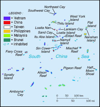
List of maritime features in the Spratly Islands

| Part of a series on the |
| Spratly Islands |
|---|
 Spratly Islands military occupations map |
| Related articles |
| Spratly Islands dispute |
| Confrontations |
| Southwest Cay incident (1975) |
| Military occupations |
 Occupied by Brunei Occupied by Brunei
 Occupied by China (PRC) Occupied by China (PRC)
 Occupied by Malaysia Occupied by Malaysia Occupied by the Philippines Occupied by the Philippines
 Occupied by Vietnam Occupied by Vietnam |
|
Map all coordinates using OpenStreetMap
Download coordinates as:
- KML
- GPX (all coordinates)
- GPX (primary coordinates)
- GPX (secondary coordinates)
This page features a series of lists of maritime features in the Spratly Islands.
Features by area
Of the hundreds of maritime features in the Spratly Islands, relatively few have land permanently above sea-level that is larger than protruding rocks. There are only 13 islands and cays with a natural area above sea-level larger than one hectare.[note 1] With the exception of Swallow Reef, prior to 2014 there had been no large-scale land reclamation beyond building breakwaters and piers, and extending runways.
This changed dramatically in 2014 with the PRC embarking on large-scale reclamations of the lagoons of Johnson South Reef (~10ha) and Fiery Cross Reef (~230ha), and other reclamations of then unknown extent at the Gaven Reefs and Cuarteron Reef.[1] Reports of the extent of land reclaimed on Swallow Reef vary. The PRC land reclamations have continued on a total of seven sites. In 2015, Subi Reef, Hughes Reef and Mischief Reef were added.[2] Refer to the table below for the most recently available data. In summary, there have been reclamations of very large areas (>640 acres = 1 sq mile) at three sites by the PRC, reclamations of large areas (10-100 acres) at eight sites (four by PRC, three by Vietnam, and one by Malaysia) and reclamations of lesser areas at a number of sites. There does not appear to have been any reclamation of Philippine occupied areas. There have been small Taiwanese reclamations at Itu Aba, very small but functionally significant reclamations at six Malaysian sites, and a number small but significant reclamations at Vietnamese sites in 2016, most particularly at Spratly Island where the runway has been extended and a sheltered harbour added.
The following table contains the 16 largest "natural" features, (i.e. not including reclaimed land),[3] plus the features with significant amounts of reclaimed land:
| # | Feature | in Atoll | "Natural" Area | Location | Currently occupied by | Reclaimed Area[1] |
|---|---|---|---|---|---|---|
| 1 | Itu Aba Island | Tizard Bank | 46.00 hectares (113.7 acres) | 10°22.5′N 114°22′E / 10.3750°N 114.367°E / 10.3750; 114.367 |  ROC (Taiping Island) ROC (Taiping Island) | ~8 acres (3.2 ha)[4] |
| 2 | Thitu Island | Thitu Reefs | 37.20 hectares (91.9 acres) | 11°03′N 114°17′E / 11.050°N 114.283°E / 11.050; 114.283 | PHI (Pagasa Island) | |
| 3 | West York Island | West York Island | 18.60 hectares (46.0 acres) | 11°05′N 115°01′E / 11.083°N 115.017°E / 11.083; 115.017 | PHI (Likas Island) | |
| 4 | Spratly Island | Spratly Island | 13.00 hectares (32.1 acres) | 08°38′N 111°55′E / 8.633°N 111.917°E / 8.633; 111.917 | VNM (Trường Sa Island) | ~37 acres (15 ha)[5] |
| 5 | Northeast Cay | North Danger Reef | 12.70 hectares (31.4 acres) | 11°28′N 114°21′E / 11.467°N 114.350°E / 11.467; 114.350 | PHI (Parola Island) | |
| 6 | Southwest Cay | North Danger Reef | 12.00 hectares (29.7 acres) | 11°26′N 114°20′E / 11.433°N 114.333°E / 11.433; 114.333 | VNM (Song Tử Tây Island) | ~7 acres (2.8 ha)[6] |
| 7 | Sin Cowe Island | Union Banks | 08.00 hectares (19.8 acres) | 09°52′N 114°19′E / 9.867°N 114.317°E / 9.867; 114.317 | VNM (Sinh Tồn Island) | ~26 acres (11 ha)[7] |
| 8 | Nanshan Island | Loaita Bank | 07.93 hectares (19.6 acres) | 10°45′N 115°49′E / 10.750°N 115.817°E / 10.750; 115.817 | PHI (Lawak Island) | |
| 9 | Sand Cay | Tizard Bank | 07.00 hectares (17.3 acres) | 10°23′N 114°28′E / 10.383°N 114.467°E / 10.383; 114.467 | VNM (Sơn Ca Island) | ~9 acres (3.6 ha)[8][9] |
| 10 | Loaita Island | Loaita Bank | 06.45 hectares (15.9 acres) | 10°40′N 114°25′E / 10.667°N 114.417°E / 10.667; 114.417 | PHI (Kota Island) | |
| 11 | Swallow Reef | Swallow Reef | 06.20 hectares (15.3 acres) | 07°22′N 113°50′E / 7.367°N 113.833°E / 7.367; 113.833 | MYS (Layang-Layang Reef) | ~95 acres (38 ha) |
| 12 | Namyit Island | Tizard Bank | 05.30 hectares (13.1 acres) | 10°11′N 114°22′E / 10.183°N 114.367°E / 10.183; 114.367 | VNM (Nam Yết Island) | |
| 13 | Amboyna Cay | Amboyna Cay | 01.60 hectares (4.0 acres) | 07°54′N 112°55′E / 7.900°N 112.917°E / 7.900; 112.917 | VNM (An Bang Island) | |
| Grierson Reef | Union Banks | 01.60 hectares (4.0 acres) | 09°54′N 114°34′E / 9.900°N 114.567°E / 9.900; 114.567 | VNM (Sinh Tồn Đông Island) | ~3 acres (1.2 ha)[10][11] | |
| West London Reef | London Reefs | 01.10 hectares (2.7 acres) | 08°52′N 112°15′E / 8.867°N 112.250°E / 8.867; 112.250 | VNM (Đá Tây A Island) | ~70 acres (28 ha)[8][10][11][12] | |
| Central London Reef | London Reefs | 00.88 hectares (2.2 acres) | 08°56′N 112°21′E / 8.933°N 112.350°E / 8.933; 112.350 | VNM (Trường Sa Đông Island) | ~4 acres (1.6 ha)[10][11] | |
| 14 | Flat Island | Loaita Bank | 00.57 hectares (1.4 acres) | 10°49′N 115°49′E / 10.817°N 115.817°E / 10.817; 115.817 | PHI (Patag Island) | |
| 15 | Loaita Cay | Loaita Bank | 00.53 hectares (1.3 acres) | 10°43′43″N 114°21′09″E / 10.72861°N 114.35250°E / 10.72861; 114.35250 | PHI (Melchora Aquino Island) | |
| 16 | Lankiam Cay | Loaita Bank | 00.44 hectares (1.1 acres) | 10°43′N 114°32′E / 10.717°N 114.533°E / 10.717; 114.533 | PHI (Panata Island) | |
| Mischief Reef | Mischief Reef | 00.00 | 09°56′N 115°32′E / 9.933°N 115.533°E / 9.933; 115.533 | PRC | ~1,379 acres (558 ha)[13][14] | |
| Subi Reef | Thitu Reefs | 00.00 | 10°55′N 114°04′E / 10.917°N 114.067°E / 10.917; 114.067 | PRC | ~976 acres (395 ha)[13][15] | |
| Fiery Cross Reef | Fiery Cross Reef | 00.00 | 09°36′N 111°57′E / 9.600°N 111.950°E / 9.600; 111.950 | PRC | ~677 acres (274 ha)[13][16] | |
| Cuarteron Reef | London Reefs | 00.00 | 08°52′N 112°50′E / 8.867°N 112.833°E / 8.867; 112.833 | PRC | ~56 acres (23 ha)[17] | |
| Gaven Reefs | Tizard Bank | 00.00 | 10°13′N 114°13′E / 10.217°N 114.217°E / 10.217; 114.217 | PRC | ~34 acres (14 ha)[18] | |
| Johnson South Reef | Union Banks | 00.00 | 09°43′N 114°17′E / 9.717°N 114.283°E / 9.717; 114.283 | PRC | ~27 acres (11 ha)[19] | |
| Hughes Reef | Union Banks | 00.00 | 09°55′N 114°30′E / 9.917°N 114.500°E / 9.917; 114.500 | PRC | ~19 acres (7.7 ha)[20][21] | |
| Pearson Reef | SW Dangerous Ground | 00.00 | 08°58′N 113°42′E / 8.967°N 113.700°E / 8.967; 113.700 | VNM (Phan Vinh Island) | ~6 acres (2.4 ha)[22] | |
| Cornwallis South Reef | SW Dangerous Ground | 00.00 | 08°43′N 114°11′E / 8.717°N 114.183°E / 8.717; 114.183 | VNM (Núi Le Reef) | ~2 acres (0.81 ha)[10][11] |
Features by major reef/bank, etc.

The boundaries of the Spratly Islands are not firmly defined. West-to-east, the islands range from the coastal waters of Vietnam to the east of Dangerous Ground and the Palawan Passage (approx. 106-117°E), and south-to-north from the coastal waters of Borneo and the southern South China Sea to the north of Dangerous Ground and the Reed Bank (approx. 3-12°N).
The major feature of the area is Dangerous Ground, an oblong area approximately 340 nautical miles (630 km; 390 mi) SW-NE, 175 nautical miles (324 km; 201 mi) at its widest, with an area of about 52,000 nm² (178,000 km²).[23] It lies approximately between 7.5–12°N, 113–117°E, and US NGA literature[23][24][25]etc. seems to consider its centre as 10°N 115°E / 10°N 115°E / 10; 115. The remainder of the Spratly Islands are mainly to the west and south of Dangerous Ground, with some features to the east.
The Spratly Islands can be roughly divided into seven sub-areas relative to Dangerous Ground:[23]
- NW of Dangerous Ground (approx. 10-12°N, 113-115°E)[24]
- NE Dangerous Ground (approx. 10-12°N, 115-117°E)[25]
- SE Dangerous Ground (approx. 7-10°N, 115-117°E)[26][27][28]
- SW Dangerous Ground (approx. 7-10°N, 113-115°E)[29]
- E of Dangerous Ground (approx. 3-12°N, east of 117°E)[25][26][28]
- S of Dangerous Ground (approx. 3- 7°N, 113-117°E)[28][30] and
- W of Dangerous Ground (approx. 3-12°N, west of 113°E)[note 2]
Within these sub-areas there are a number of major reefs and banks, as well as ungrouped maritime features.[3]
Starting in the NW, and progressing in a generally SW direction, the features include:
| Sub-area | Group | Vicinity | Contains: |
|---|---|---|---|
| NW | North Danger Reef | 11°25′N 114°21′E / 11.417°N 114.350°E / 11.417; 114.350 | North Reef (Spratly Islands) [zh]; Northeast Cay; Shira Islet; Southwest Cay; Jenkins Patches; South Reef; Sabine Patches; Farquharson Patches; Day Shoal; Iroquois Ridge |
| NW | Trident & Lys | Trident Shoal [zh], Lys Shoal [zh] | |
| NW | Thitu Reefs [zh] | 11°03′N 114°17′E / 11.050°N 114.283°E / 11.050; 114.283 | Thitu Island; Thitu Reef [zh]; Sandy Cay (Spratly Islands) [zh] |
| NW | (Near Thitu Reefs [zh]) | 10°55′N 114°04′E / 10.917°N 114.067°E / 10.917; 114.067 | Subi Reef |
| NW | Loaita Banks | 10°45′N 114°30′E / 10.750°N 114.500°E / 10.750; 114.500 | Lankiam Cay; Loaita Cay; Loaita Nan; Loaita Island |
| NW | (East of Loaita Banks) | 10°55′N 114°45′E / 10.917°N 114.750°E / 10.917; 114.750 | Menzies Reef [zh] , Irving Reef, West York Island |
| NW | Tizard Banks | 10°15′N 114°30′E / 10.250°N 114.500°E / 10.250; 114.500 | Ban Than Reef/Zhongzhou Reef; Eldad Reef]; Gaven Reefs; Namyit Island; Petley Reef; Sand Cay; Taiping Island/Itu Aba |
| NW | (West of Tizard Banks) | Western Reef, Discovery Great Reef, Discovery Small Reef [zh] | |
| W | (West of Union Banks) | 9°30′N 112°30′E / 9.500°N 112.500°E / 9.500; 112.500 | Fiery Cross Reef, Dhaulle Shoal [zh], Coronation Bank [zh] |
| SW | Union Banks | 09°50′N 114°30′E / 9.833°N 114.500°E / 9.833; 114.500 | Collins Reef/Johnson North Reef, Edmund Reef [zh], Grierson Reef/Sin Cowe East Island, Hallet Reef [zh], Higgens Reef [zh], Holiday Reef [zh], Hughes Reef, Johnson South Reef, Jones Reef [zh]/Zhangxi Jiao, Lansdowne Reef, McKennan Reef [zh]/Kennan Reef, Sin Cowe Island, Whitson Reef, Empire Reef [zh], Loveless Reef [zh] |
| NE | Reed Tablemount | 11°20′N 116°50′E / 11.333°N 116.833°E / 11.333; 116.833 | Reed Bank, Nares Bank [vi; zh],[31] Marie Louise Bank [vi; zh],[32] Pennsylvania North Reef [vi; zh],[33] Iroquois Reef [vi; zh][34] |
| NE | NE Dangerous Ground | 11°N 116°E / 11°N 116°E / 11; 116 | Jackson Atoll [zh], Nanshan Island, Flat Island, Third Thomas Shoal, Hopkins Reef [zh], Amy Douglas Bank [zh]/Hirane Shoal, Hardy Reef [zh]/Hubo Reef, Sandy Shoal [zh], Lord Auckland Shoal [zh], Carnatic Shoal [zh], Seahorse Shoal [zh]/Seashore Shoal/Routh Shoal, Iroquois Reef [zh], Leslie Bank [zh], Templar Bank [zh], Southern Bank (Spratly Islands) [zh], Katimugan Banks [zh] [dubious – discuss], Tagpi [zh] [dubious – discuss], Pennsylvania South Reef [zh]/Magat Salamat Reef, |
| NE | Southampton Reefs | Hopps Reef [zh] ; Livock Reef [zh] | |
| E | (East & SE Dangerous Ground) | Bombay Shoal [zh], Royal Captain Shoal, Half Moon Shoal, South Viper Shoal [zh] | |
| SE | SE Dangerous Ground | 9°N 116°E / 9°N 116°E / 9; 116 | Sabina Shoal, Boxall Reef [zh], Second Thomas Shoal, Mischief Reef, First Thomas Shoal, Alicia Annie Reef [zh], Commodore Reef, North Viper Shoal [zh], North East Shoal [zh], Director Reef [zh], Glasgow Bank [zh], Investigator Northeast Shoal |
| SW | SW Dangerous Ground | 9°N 114°E / 9°N 114°E / 9; 114 | Maralie Reef [zh]/Bittern Reef, Alison Reef, Cornwallis South Reef, Pearson Reef, Pigeon Reef [zh], Investigator Shoal, Ardasier Reef, Ardasier Bank [zh], Erica Reef, Mariveles Reef, Dallas Reef, Barque Canada Reef, Royal Charlotte Reef [zh] |
| W | London Reefs | 08°50′N 112°30′E / 8.833°N 112.500°E / 8.833; 112.500 | Central London Reef; Cuarteron Reef; East London Reef; West London Reef |
| W | (Spratly Island vicinity) | 08°40′N 111°45′E / 8.667°N 111.750°E / 8.667; 111.750 | Spratly Island, Ladd Reef, Jubilee Bank (Spratly Islands) [zh] |
| W | (West of Spratly Island) | Scawfell Shoal, Charlotte Bank, Vanguard Bank [zh], Julia Shoal, Royal Bishop Shoal | |
| W | (Southwest of Spratly Island) | Alexandra Bank [zh]; Grainger Bank [zh]; Prince of Wales Bank [zh]; Prince Consort Bank [zh] | |
| W | Rifleman Bank [zh] | 07°50′N 111°40′E / 7.833°N 111.667°E / 7.833; 111.667 | Bombay Castle (bãi Ba Kè); Johnson Patch [zh] (tức là Bãi Vũng Mây); Kingston Shoal [zh] (Bãi Đinh); Orleana Shoal [zh] (Bãi Đất), Bãi Ráng Chiều, bãi Ngũ Sắc, bãi Xà Cừ, bãi Vũ Tích |
| S | Amboyna Cay; Swallow Reef; Louisa Reef | ||
| S | Luconia Shoals | 05°30′N 112°30′E / 5.500°N 112.500°E / 5.500; 112.500 | North Luconia Shoals [zh]: Friendship Shoal [zh], Hardie Reef [zh], Aitken Reef [zh], Buck Reef [zh], Moody Reef [zh], Seahorse Breakers [zh], Tripp Reef [zh], Hayes Reef [zh] South Luconia Shoals [zh]: Stigant Reef [zh], Connell Reef [zh], Herald Reef (Spratly Islands) [zh], Comus Shoal [zh], Richmond Reef [zh], Luconia Breakers [zh] |
Features by name
- A
- Amboyna Cay
- Ardasier Reef
- Ayungin Reef / shoal (Second Thomas)
- B
- Balagtas Reef (Irving Reef)
- Ban Than Reef (Zhongzhou Reef)
- Boji Jiao (Erica Reef)
- Bombay Castle
- C
- Calderon Reef (Cuarteron Reef)
- Celerio Reef (Swallow Reef)
- Central London Reef
- Chigua Reef (Johnson South Reef)
- Collins Reef (Johnson North Reef)
- Cuarteron Reef (Calderon Reef)
- D
- Dallas Reef
- Dangerous Ground
- Dongmen Reef (Hughes Reef)
- E
- East London Reef
- Enola Reef (Erica Reef)
- Erica Reef (Boji Jiao,Enola Reef, Gabriela Silang Reef, Terumbu Siput)
- F
- Fiery Cross Reef
- Flat Island (Patag Island)
- First Thomas Shoal
- G
- Gabriela Silang Reef (Erica Reef)
- Gaven Reefs / Gaven North Reef / Gaven South Reef
- H
- Half Moon Shoal
- Hardy Reef (Hubo Reef)
- Hubo Reef (Hardy Reef)
- Hughes Reef (Dongmen Reef)
- I
- Investigator Shoal (Pawikan Reef)
- Irving Reef (Balagtas Reef)
- Itu Aba (Ligao Island, Taiping Island)
- J
- James Shoal
- Johnson Reef:
- Johnson North Reef (Collins)
- Johnson South Reef (Chigua)
- K
- Kalayaan Islands / Kalayaan, Palawan
- Kota Island (Loaita)
- L
- Ladd Reef
- Lankiam Cay (Panata Island)
- Lawak Island (Nanshan Island)
- Layang Layang / Layang Layang Island (Swallow)
- Ligao Island (Itu Aba, Taiping Island)
- Likas Island (West York Island)
- Loaita Cay / Loaita Nan / Loaita Island (Kota)
- London Reefs
- Louisa Reef
- Luconia Shoals
- M
- Magat Salamat Reef (Pennsylvania South Reef)
- Mariveles Reef
- Menzies Reef
- Mischief Reef (Panganiban Reef)
- Republic of Morac-Songhrati-Meads
- N
- Namyit Island
- Nanshan Island (Lawak Island)
- North Danger Reef
- Northeast Cay (Parola Island)
- P
- Pagasa Island (Thitu Island)
- Panata Island (Lankiam Cay)
- Panganiban Reef (Mischief Reef)
- Parola Island (Northeast Cay)
- Patag Island (Flat Island)
- Pawikan Reef (Investigator Shoal)
- Pennsylvania South Reef (Magat Salamat Reef)
- Pugad Island (Southwest Cay)
- R
- S
- Sabina Shoal
- Sand Cay
- Second Thomas Reef / Second Thomas Shoal (Ayungin)
- Sin Cowe Island
- Southwest Cay (Pugad Island)
- Spratly Island / Storm Island
- Subi Reef
- Swallow Reef (Celerio, Layang Layang)
- T
- Taiping Island (Itu Aba, Ligao Island)
- Terumbu Siput (Erica Reef)
- Thitu Island (Pagasa Island)
- Third Thomas Shoal
- U
- W
- West London Reef
- West York Island (Likas Island)
- Western Reef
- Whitsun Reef
- Z
- Zhongzhou Reef (Ban Than Reef)
Features by occupier and/or claimant

A feature is occupied by a country if one of the following is true:
- Soldiers and/or civilian citizens of a country are present in the feature, either by building structures over the feature to house the citizens (most features are of this type) or by manning a ship anchored over the feature (Philippine-occupied Irving Reef is of this type).
- Regularly visited by soldiers of a country, not necessarily having soldiers present in it 24 hours. These features must lie near (within 9 miles (14 km)) a feature occupied by the country in the way of the first condition. Presence of structures is not necessary. This is the case of Philippine-occupied Flat Island and Lankiam Cay where soldiers stationed at Nanshan Island and Loaita Island respectively, regularly visit on a daily basis.[citation needed]
The effective visible distance of horizon from a 15-meter (typical large structure) height above sea-level is 9 miles (14 km). This makes features occupied by the second condition to be also labeled as "occupied" since they can be guarded far away. However, not all features within the 9-mile (14 km) radius can be considered as absolutely occupied. This is especially true for features that lie between and within 9 miles (14 km) of two or more features occupied by different countries.[citation needed] (See Virtually Occupied or Controlled table)
Summary
| Int'l Name | Co-ords | Sub-group | Occupant/s | Since | Notes |
|---|---|---|---|---|---|
| Itu Aba | 10°22.5′N 114°22′E / 10.3750°N 114.367°E / 10.3750; 114.367 | Tizard Bank | ROC (Taiwan) | 1946 | |
| Ban Than Reef | 10°23′N 114°24′E / 10.383°N 114.400°E / 10.383; 114.400 | Tizard Bank | ROC (Taiwan) | 1946 | |
| Cuarteron Reef | 08°53′N 112°51′E / 8.883°N 112.850°E / 8.883; 112.850 | London Reefs | PRC (China) | 1988 | |
| Fiery Cross Reef | 09°37′N 112°58′E / 9.617°N 112.967°E / 9.617; 112.967 | W of Union Banks | PRC (China) | 1988 | Military Garrison |
| Gaven Reefs | 10°13′N 114°13′E / 10.217°N 114.217°E / 10.217; 114.217 | Tizard Bank | PRC (China) | 1988 | |
| Hughes Reef | 09°55′N 114°30′E / 9.917°N 114.500°E / 9.917; 114.500 | Union Banks | PRC (China) | 1988 | Lighthouse |
| Johnson South Reef | 09°43′N 114°17′E / 9.717°N 114.283°E / 9.717; 114.283 | Union Banks | PRC (China) | 1988 | |
| Mischief Reef | 09°55′N 115°32′E / 9.917°N 115.533°E / 9.917; 115.533 | SE Dangerous Ground | PRC (China) | 1995 | Airfield |
| Subi Reef | 10°55′N 114°04′E / 10.917°N 114.067°E / 10.917; 114.067 | W of Thitu Reefs [zh] | PRC (China) | 2013 | Military Garrison |
| Flat Island | 10°49′N 115°49′E / 10.817°N 115.817°E / 10.817; 115.817 | SE Dangerous Ground | PHI | 1974 | |
| Lankiam Cay | 10°43′N 114°32′E / 10.717°N 114.533°E / 10.717; 114.533 | Loaita Banks | PHI | - | |
| Loaita Cay | 10°43′43″N 114°21′09″E / 10.72861°N 114.35250°E / 10.72861; 114.35250 | Loaita Banks | PHI | - | |
| Loaita Island | 10°40′N 114°25′E / 10.667°N 114.417°E / 10.667; 114.417 | Loaita Banks | PHI | - | |
| Nanshan Island | 10°44′N 115°48′E / 10.733°N 115.800°E / 10.733; 115.800 | NE Dangerous Ground | PHI | - | |
| Northeast Cay | 11°27′N 114°21′E / 11.450°N 114.350°E / 11.450; 114.350 | North Danger Reef | PHI | - | |
| Thitu Island | 11°03′N 114°17′E / 11.050°N 114.283°E / 11.050; 114.283 | Thitu Reefs [zh] | PHI | - | |
| West York Island | 11°05′N 115°01′E / 11.083°N 115.017°E / 11.083; 115.017 | NW Dangerous Ground | PHI | - | |
| Commodore Reef | 08°22′N 115°12′E / 8.367°N 115.200°E / 8.367; 115.200 | SE Dangerous Ground | PHI | - | |
| Irving Reef | 10°52′N 114°55′E / 10.867°N 114.917°E / 10.867; 114.917 | NNW Dangerous Ground | PHI | - | |
| Second Thomas Shoal | 09°44′N 115°52′E / 9.733°N 115.867°E / 9.733; 115.867 | NE Dangerous Ground | PHI | 1999 | Navy Outpost |
| Southwest Cay | 11°26′N 114°20′E / 11.433°N 114.333°E / 11.433; 114.333 | North Danger Reef | VNM | 1975/04/14 | Lighthouse |
| Sand Cay | 10°23′N 114°29′E / 10.383°N 114.483°E / 10.383; 114.483 | Tizard Bank | VNM | 1975/04/25 | Lighthouse |
| Namyit Island | 10°11′N 114°22′E / 10.183°N 114.367°E / 10.183; 114.367 | Tizard Bank | VNM | 1975/04/27 | Lighthouse |
| Sin Cowe Island | 09°53′N 114°20′E / 9.883°N 114.333°E / 9.883; 114.333 | Union Banks | VNM | 1975/04/27 | Lighthouse |
| Spratly Island | 08°38′N 114°25′E / 8.633°N 114.417°E / 8.633; 114.417 | Spratly Island vicinity | VNM | 1975/04/29 | Lighthouse |
| Amboyna Cay | 07°54′N 112°55′E / 7.900°N 112.917°E / 7.900; 112.917 | VNM | 1975/04/29 | Lighthouse | |
| Grierson Reef /Sin Cowe East Island | 09°54′N 114°34′E / 9.900°N 114.567°E / 9.900; 114.567 | Union Banks | VNM | 1978/03/23 | |
| Central London Reef | 08°56′N 112°21′E / 8.933°N 112.350°E / 8.933; 112.350 | London Reefs | VNM | 1978/04/02 | |
| Pearson Reef | 08°57′N 113°40′E / 8.950°N 113.667°E / 8.950; 113.667 | SW Dangerous Ground | VNM | 1978/04/10 | |
| Barque Canada Reef | 08°10′N 113°18′E / 8.167°N 113.300°E / 8.167; 113.300 | NE Dangerous Ground | VNM | 1987/02 | |
| West London Reef | 08°52′N 112°14′E / 8.867°N 112.233°E / 8.867; 112.233 | London Reefs | VNM | 1988/01/15 | Lighthouse |
| Ladd Reef | 08°41′N 111°40′E / 8.683°N 111.667°E / 8.683; 111.667 | Spratly Island vicinity | VNM | 1988/02/05 | Lighthouse |
| Discovery Great Reef | 10°04′N 113°51′E / 10.067°N 113.850°E / 10.067; 113.850 | W of Tizard Banks | VNM | 1988/02/06 | |
| Pigeon Reef [zh] | 08°51′N 114°39′E / 8.850°N 114.650°E / 8.850; 114.650 | SW Dangerous Ground | VNM | 1988/02/07 | Lighthouse |
| East London Reef | 08°50′N 112°36′E / 8.833°N 112.600°E / 8.833; 112.600 | London Reefs | VNM | 1988/02/19 | |
| Alison Reef | 08°51′N 114°00′E / 8.850°N 114.000°E / 8.850; 114.000 | SW Dangerous Ground | VNM | 1988/03/20 | |
| Cornwallis South Reef | 08°43′N 114°11′E / 8.717°N 114.183°E / 8.717; 114.183 | SW Dangerous Ground | VNM | 1988/03/20 | |
| South Reef | 11°23′N 114°18′E / 11.383°N 114.300°E / 11.383; 114.300 | North Danger Reef | VNM | 1988/04/02 | |
| Petley Reef | 10°24′N 114°35′E / 10.400°N 114.583°E / 10.400; 114.583 | Tizard Bank | VNM | 1988/04/13 | |
| Collins Reef | 09°46′N 114°15′E / 9.767°N 114.250°E / 9.767; 114.250 | Union Banks | VNM | 1988/06/28 | |
| Lansdowne Reef | 09°47′N 114°22′E / 9.783°N 114.367°E / 9.783; 114.367 | Union Banks | VNM | 1988/06/28 | |
| Bombay Castle | 07°56′N 111°43′E / 7.933°N 111.717°E / 7.933; 111.717 | Riflemen Bank [zh] | VNM | 1989/06/30 | Lighthouse |
| Prince of Wales Bank [zh] | 08°09′N 110°36′E / 8.150°N 110.600°E / 8.150; 110.600 | Southwest Bank | VNM | 1989/06/30 | Lighthouse |
| Vanguard Bank [zh] | 07°32′N 109°45′E / 7.533°N 109.750°E / 7.533; 109.750 | West Spratlys | VNM | 1989/07/05 | Lighthouse, China Coast Guard regular patrol |
| Prince Consort Bank [zh] | 07°55′N 109°58′E / 7.917°N 109.967°E / 7.917; 109.967 | Southwest Bank | VNM | 1990/11/04 | Lighthouse |
| Grainger Bank [zh] | 07°49′N 110°30′E / 7.817°N 110.500°E / 7.817; 110.500 | Southwest Bank | VNM | 1991/11/03 | Lighthouse |
| Alexandra Bank [zh] | 08°01′N 110°38′E / 8.017°N 110.633°E / 8.017; 110.633 | Southwest Bank | VNM | 1991/11/30 | Lighthouse |
| Orleana Shoal [zh] | 07°41′N 111°43′E / 7.683°N 111.717°E / 7.683; 111.717 | Riflemen Bank [zh] | VNM | 1998/07/03 | Lighthouse |
| Kingston Shoal [zh] | 07°34′6″N 111°33′13″E / 7.56833°N 111.55361°E / 7.56833; 111.55361 | Riflemen Bank [zh] | VNM | 1998/07/07 | Lighthouse |
| Swallow Reef | 07°22′N 113°50′E / 7.367°N 113.833°E / 7.367; 113.833 | MYS | 1983 | RMN offshore EEZ station "Lima" | |
| Ardasier Reef | 07°38′N 113°56′E / 7.633°N 113.933°E / 7.633; 113.933 | SW Dangerous Ground | MYS | 1986 | RMN offshore EEZ station "Uniform" |
| Mariveles Reef | 08°00′N 113°54′E / 8.000°N 113.900°E / 8.000; 113.900 | SW Dangerous Ground | MYS | 1986 | RMN offshore EEZ station "Mike" |
| Dallas Reef | 07°37′N 113°48′E / 7.617°N 113.800°E / 7.617; 113.800 | SW Dangerous Ground | MYS | 1987 (or 1986) | |
| Erica Reef | 08°06′N 114°08′E / 8.100°N 114.133°E / 8.100; 114.133 | SW Dangerous Ground | MYS | 1999 | RMN offshore EEZ station "Sierra" |
| Investigator Shoal | 08°07′N 114°42′E / 8.117°N 114.700°E / 8.117; 114.700 | SW Dangerous Ground | MYS | 1999 | RMN offshore EEZ station "Papa" |
| James Shoal | 03°58.5′N 112°21′E / 3.9750°N 112.350°E / 3.9750; 112.350 | - | MYS[35] | China Coast Guard regular patrol | |
| Louisa Reef | 06°20′N 113°14′E / 6.333°N 113.233°E / 6.333; 113.233 | BRU | - | ||
| Aitken Reef [zh] | 5°54′0″N 112°31′30″E / 5.90000°N 112.52500°E / 5.90000; 112.52500 | Luconia Shoals | Unoccupied, near | ||
| Alicia Annie Reef [zh] | 9°21′N 115°26′E / 9.350°N 115.433°E / 9.350; 115.433 | SW Dangerous Ground | |||
| Amy Douglas Bank [zh] /Hirane Shoal | 10°50′N 116°15′E / 10.833°N 116.250°E / 10.833; 116.250 | NE Dangerous Ground | Unoccupied, the east of the 116°E meridian | ||
| Ardasier Bank [zh] | 7°36′N 114°17′E / 7.600°N 114.283°E / 7.600; 114.283 | SW Dangerous Ground | Unoccupied, near | ||
| Bombay Shoal [zh] | 9°26′N 116°55′E / 9.433°N 116.917°E / 9.433; 116.917 | ESE Dangerous Ground | Unoccupied, the east of the 116°E meridian | ||
| Boxall Reef [zh] | 9°36′N 116°10′E / 9.600°N 116.167°E / 9.600; 116.167 | SE Dangerous Ground | Unoccupied, the east of the 116°E meridian | ||
| Buck Reef [zh] | 5°48′15″N 112°32′15″E / 5.80417°N 112.53750°E / 5.80417; 112.53750 | Luconia Shoals | Unoccupied, near | ||
| Carnatic Shoal [zh] | 10°06′N 117°21′E / 10.100°N 117.350°E / 10.100; 117.350 | NE Dangerous Ground | Unoccupied, the east of the 116°E meridian | ||
| Comus Shoal [zh] | 5°2′12″N 112°56′20″E / 5.03667°N 112.93889°E / 5.03667; 112.93889 | Luconia Shoals | Unoccupied, near | ||
| Connell Reef [zh] | 5°4′40″N 112°34′45″E / 5.07778°N 112.57917°E / 5.07778; 112.57917 | Luconia Shoals | Unoccupied, near | ||
| Coronation Bank [zh] | 9°21′N 111°44′E / 9.350°N 111.733°E / 9.350; 111.733 | W of Union Banks | |||
| Dhaulle Shoal [zh] | 9°28′N 112°24′E / 9.467°N 112.400°E / 9.467; 112.400 | W of Union Banks | |||
| Director Reef [zh] | 8°28′N 115°55′E / 8.467°N 115.917°E / 8.467; 115.917 | SE Dangerous Ground | |||
| Discovery Small Reef [zh] | 10°01′N 114°02′E / 10.017°N 114.033°E / 10.017; 114.033 | W of Tizard Banks | |||
| Edmund Reef [zh] | 9°54′N 114°23.5′E / 9.900°N 114.3917°E / 9.900; 114.3917 | Union Banks | |||
| Eldad Reef | 10°21′N 114°42′E / 10.350°N 114.700°E / 10.350; 114.700 | Tizard Bank | Unoccupied, China Coast Guard regular patrol | ||
| Empire Reef [zh] | 9°58.5′N 114°35.5′E / 9.9750°N 114.5917°E / 9.9750; 114.5917 | Union Banks | |||
| First Thomas Shoal | 09°20′N 115°57′E / 9.333°N 115.950°E / 9.333; 115.950 | SE Dangerous Ground | Unoccupied, China Coast Guard regular patrol | ||
| Friendship Shoal [zh] | 5°57′18″N 112°31′43″E / 5.95500°N 112.52861°E / 5.95500; 112.52861 | Luconia Shoals | Unoccupied, near | ||
| Ganges Reef [zh] | 10°20′N 115°04′E / 10.333°N 115.067°E / 10.333; 115.067 | - | |||
| Glasgow Bank [zh] | 8°28′N 115°30′E / 8.467°N 115.500°E / 8.467; 115.500 | SE Dangerous Ground | |||
| Half Moon Shoal | 8°52′N 116°16′E / 8.867°N 116.267°E / 8.867; 116.267 | ESE Dangerous Ground | Unoccupied, the east of the 116°E meridian | ||
| Hallet Reef [zh] | 9°56′N 114°31′E / 9.933°N 114.517°E / 9.933; 114.517 | Union Banks | Unoccupied, near Hughes Reef | ||
| Hardie Reef [zh] | 5°47′0″N 112°26′45″E / 5.78333°N 112.44583°E / 5.78333; 112.44583 | Luconia Shoals | Unoccupied, near | ||
| Hardy Reef [zh]/Hubo Reef | 10°08′N 116°08′E / 10.133°N 116.133°E / 10.133; 116.133 | NE Dangerous Ground | Unoccupied, the east of the 116°E meridian | ||
| Hayes Reef [zh] | 5°22′N 112°39′E / 5.367°N 112.650°E / 5.367; 112.650 | Luconia Shoals | Unoccupied, near | ||
| Herald Reef (Spratly Islands) [zh] | 4°58′15″N 112°36′15″E / 4.97083°N 112.60417°E / 4.97083; 112.60417 | Luconia Shoals | Unoccupied, near | ||
| Higgens Reef [zh] | 09°48′N 114°24′E / 9.800°N 114.400°E / 9.800; 114.400 | Union Banks | |||
| Holiday Reef [zh] | 9°58′N 114°34′E / 9.967°N 114.567°E / 9.967; 114.567 | Union Banks | |||
| Hopkins Reef [zh] | 10°48.5′N 116°05.5′E / 10.8083°N 116.0917°E / 10.8083; 116.0917 | NE Dangerous Ground | Unoccupied, the east of the 116°E meridian | ||
| Hopps Reef [zh] | 10°15′N 115°21.5′E / 10.250°N 115.3583°E / 10.250; 115.3583 | Southampton Reefs | |||
| Investigator Northeast Shoal | 9°10.5′N 116°27.5′E / 9.1750°N 116.4583°E / 9.1750; 116.4583 | SE Dangerous Ground | Unoccupied, the east of the 116°E meridian | ||
| Iroquois Reef [zh] | 10°37.5′N 116°10.5′E / 10.6250°N 116.1750°E / 10.6250; 116.1750 | NE Dangerous Ground | Unoccupied, the east of the 116°E meridian | ||
| Jackson Atoll [zh] | 10°29′N 115°45′E / 10.483°N 115.750°E / 10.483; 115.750 | NE Dangerous Ground | |||
| Johnson Patch [zh] | 07°48′15″N 111°34′29″E / 7.80417°N 111.57472°E / 7.80417; 111.57472 | Union Banks | Riflemen Bank [zh] | Unoccupied, near Bombay Castle | |
| Jones Reef [zh]/Zhangxi Jiao | 9°50′N 114°28′E / 9.833°N 114.467°E / 9.833; 114.467 | Union Banks | |||
| Jubilee Bank (Spratly Islands) [zh] | 8°32′N 111°29′E / 8.533°N 111.483°E / 8.533; 111.483 | Spratly Island vicinity | Unoccupied, near Ladd Reef | ||
| Katimugan Banks [zh] [dubious – discuss] | 10°30′N 116°40′E / 10.500°N 116.667°E / 10.500; 116.667 | NE Dangerous Ground- | Unoccupied, the east of the 116°E meridian | ||
| Leslie Bank [zh] | 11°05′N 117°28′E / 11.083°N 117.467°E / 11.083; 117.467 | NE Dangerous Ground- | Unoccupied, the east of the 116°E meridian | ||
| Livock Reef [zh] | 10°11′N 115°18′E / 10.183°N 115.300°E / 10.183; 115.300 | Southampton Reefs | |||
| Loaita Nan | 10°42′N 114°19′E / 10.700°N 114.317°E / 10.700; 114.317 | Loaita Banks | Unoccupied, near Loaita Cay | ||
| Lord Auckland Shoal [zh] | 10°20′N 117°17′E / 10.333°N 117.283°E / 10.333; 117.283 | NE Dangerous Ground | Unoccupied, the east of the 116°E meridian | ||
| Loveless Reef [zh] | 9°51′N 114°17′E / 9.850°N 114.283°E / 9.850; 114.283 | Union Banks | Unoccupied, near Sin Cowe Island | ||
| Luconia Breakers [zh] | 4°59′N 112°37′E / 4.983°N 112.617°E / 4.983; 112.617 | Luconia Shoals | Unoccupied, near , China Coast Guard regular patrol | ||
| Lys Shoal [zh] | 11°19′N 114°35′E / 11.317°N 114.583°E / 11.317; 114.583 | Trident & Lys | |||
| Maralie Reef [zh] /Bittern Reef | 9°12′N 113°40′E / 9.200°N 113.667°E / 9.200; 113.667 | SW Dangerous Ground | |||
| Marie Louise Bank [zh] | 11°55′N 116°47′E / 11.917°N 116.783°E / 11.917; 116.783 | Reed Tablemount | Unoccupied, the east of the 116°E meridian | ||
| McKennan Reef [zh] /Kennan Reef | 9°54′N 114°28′E / 9.900°N 114.467°E / 9.900; 114.467 | Union Banks | Unoccupied, near Hughes Reef | ||
| Menzies Reef [zh] | 11°09′N 114°48′E / 11.150°N 114.800°E / 11.150; 114.800 | NNW Dangerous Ground | |||
| Moody Reef [zh] | 5°37′38″N 112°21′38″E / 5.62722°N 112.36056°E / 5.62722; 112.36056 | Luconia Shoals | Unoccupied, near | ||
| Nares Bank [zh] | 11°35′N 116°15′E / 11.583°N 116.250°E / 11.583; 116.250 | Reed Tablemount | Unoccupied, the east of the 116°E meridian | ||
| North East Shoal [zh] | 8°31′N 115°15′E / 8.517°N 115.250°E / 8.517; 115.250 | SE Dangerous Ground | |||
| North Luconia Shoals [zh] | 5°39′N 112°28′E / 5.650°N 112.467°E / 5.650; 112.467 | Luconia Shoals | Unoccupied, near | ||
| South Luconia Shoals [zh] | 5°05′N 112°40′E / 5.083°N 112.667°E / 5.083; 112.667 | Luconia Shoals | Unoccupied, near | ||
| North Reef (Spratly Islands) [zh] | 11°28′N 114°23′E / 11.467°N 114.383°E / 11.467; 114.383 | North Danger Reef | Unoccupied, near Northeast Cay | ||
| North Viper Shoal [zh] | 8°02′N 115°23′E / 8.033°N 115.383°E / 8.033; 115.383 | SE Dangerous Ground | |||
| South Viper Shoal [zh] | 7°30′N 115°00′E / 7.500°N 115.000°E / 7.500; 115.000 | ESE Dangerous Ground | |||
| Owen Shoal [zh] | 8°9′N 111°58′E / 8.150°N 111.967°E / 8.150; 111.967 | - | Unoccupied, near Bombay Castle | ||
| Pennsylvania North Reef [zh] | 10°48′N 116°51′E / 10.800°N 116.850°E / 10.800; 116.850 | Reed Tablemount | Unoccupied, the east of the 116°E meridian | ||
| Pennsylvania South Reef [zh] /Magat Salamat Reef | 10°23′N 116°34′E / 10.383°N 116.567°E / 10.383; 116.567 | NE Dangerous Ground- | Unoccupied, the east of the 116°E meridian | ||
| Reed Bank | 11°20′N 116°50′E / 11.333°N 116.833°E / 11.333; 116.833 | Reed Tablemount | Unoccupied, the east of the 116°E meridian | ||
| Richmond Reef [zh] | 5°3′0″N 112°39′52″E / 5.05000°N 112.66444°E / 5.05000; 112.66444 | Luconia Shoals | Unoccupied, near | ||
| Royal Captain Shoal | 9°01′N 116°40′E / 9.017°N 116.667°E / 9.017; 116.667 | ESE Dangerous Ground | Unoccupied, the east of the 116°E meridian | ||
| Royal Charlotte Reef [zh] | 6°57′N 113°35′E / 6.950°N 113.583°E / 6.950; 113.583 | SW Dangerous Ground | Unoccupied, near , China Coast Guard regular patrol | ||
| Sabina Shoal | 9°45′N 116°28′E / 9.750°N 116.467°E / 9.750; 116.467 | SE Dangerous Ground | Unoccupied, the east of the 116°E meridian | ||
| Sandy Cay (Spratly Islands) [zh] | 11°04′N 114°13′E / 11.067°N 114.217°E / 11.067; 114.217 | Thitu Reefs [zh] | Unoccupied, near Thitu Island | ||
| Sandy Shoal [zh] | 11°02′N 117°38′E / 11.033°N 117.633°E / 11.033; 117.633 | NE Dangerous Ground- | Unoccupied, the east of the 116°E meridian | ||
| Seahorse Breakers [zh] | 5°30′N 112°35′E / 5.500°N 112.583°E / 5.500; 112.583 | Luconia Shoals | Unoccupied, near | ||
| Seahorse Shoal [zh] | 10°48′N 117°47′E / 10.800°N 117.783°E / 10.800; 117.783 | NE Dangerous Ground- | Unoccupied, the east of the 116°E meridian | ||
| Southern Bank (Spratly Islands) [zh] | 10°28′N 116°45′E / 10.467°N 116.750°E / 10.467; 116.750 | NE Dangerous Ground- | Unoccupied, the east of the 116°E meridian | ||
| Stag Shoal [zh] | 8°27′N 112°57′E / 8.450°N 112.950°E / 8.450; 112.950 | - | |||
| Stigant Reef [zh] | 5°1′28″N 112°28′45″E / 5.02444°N 112.47917°E / 5.02444; 112.47917 | Luconia Shoals | Unoccupied, near | ||
| Tagpi [zh] [dubious – discuss] | 10°33′N 116°56′E / 10.550°N 116.933°E / 10.550; 116.933 | NE Dangerous Ground- | Unoccupied, the east of the 116°E meridian | ||
| Templar Bank [zh] | 11°01′N 117°17′E / 11.017°N 117.283°E / 11.017; 117.283 | NE Dangerous Ground- | Unoccupied, the east of the 116°E meridian | ||
| Third Thomas Shoal | 10°54′N 115°56′E / 10.900°N 115.933°E / 10.900; 115.933 | NE Dangerous Ground | |||
| Thitu Reef [zh] | 11°05′N 114°23′E / 11.083°N 114.383°E / 11.083; 114.383 | Thitu Reefs [zh] | Unoccupied, near Thitu Island | ||
| Trident Shoal [zh] | 11°24′N 114°40′E / 11.400°N 114.667°E / 11.400; 114.667 | Trident & Lys | |||
| Tripp Reef [zh] | 5°28′30″N 112°28′30″E / 5.47500°N 112.47500°E / 5.47500; 112.47500 | Luconia Shoals | Unoccupied, near | ||
| Western Reef | 10°14′N 113°38.33′E / 10.233°N 113.63883°E / 10.233; 113.63883 | W of Tizard Banks | |||
| Whitson Reef | 09°59′N 114°39′E / 9.983°N 114.650°E / 9.983; 114.650 | Union Banks | Unoccupied, China Coast Guard regular patrol |


