Mellau
You can help expand this article with text translated from the corresponding article in German. (April 2010) Click [show] for important translation instructions.
- View a machine-translated version of the German article.
- Machine translation, like DeepL or Google Translate, is a useful starting point for translations, but translators must revise errors as necessary and confirm that the translation is accurate, rather than simply copy-pasting machine-translated text into the English Wikipedia.
- Do not translate text that appears unreliable or low-quality. If possible, verify the text with references provided in the foreign-language article.
- You must provide copyright attribution in the edit summary accompanying your translation by providing an interlanguage link to the source of your translation. A model attribution edit summary is
Content in this edit is translated from the existing German Wikipedia article at [[:de:Mellau]]; see its history for attribution. - You may also add the template
{{Translated|de|Mellau}}to the talk page. - For more guidance, see Wikipedia:Translation.
Place in Vorarlberg, Austria
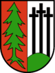
Coat of arms

Location in the district
(2018-01-01)[2]
6881
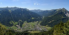
Mellau is a town in the Bregenz Forest in the westernmost Austrian state of Vorarlberg, part of the district of Bregenz.
Geography
Mellau covers an area of 40.55 km2. Mellau lies at the foot of the Kanisfluh mountain which is considered to be the Bregenz Forest's landmark.
History
From 1805 to 1814 Mellau belonged to Bavaria but then reverted to Austria. In 1870 there was a great fire in Mellau: The church, the school, the rectory and 18 other houses were razed. After the Second World War, from 1945 to 1955 the town was in the French zone of occupation.
Population
The municipality has about 1300 inhabitants.
| Year | Pop. | ±% |
|---|---|---|
| 1869 | 650 | — |
| 1880 | 627 | −3.5% |
| 1890 | 583 | −7.0% |
| 1900 | 616 | +5.7% |
| 1910 | 620 | +0.6% |
| 1923 | 645 | +4.0% |
| 1934 | 749 | +16.1% |
| 1939 | 704 | −6.0% |
| 1951 | 871 | +23.7% |
| 1961 | 922 | +5.9% |
| 1971 | 1,058 | +14.8% |
| 1981 | 1,088 | +2.8% |
| 1991 | 1,171 | +7.6% |
| 2001 | 1,282 | +9.5% |
| 2011 | 1,308 | +2.0% |
Coat of arms
The coat of arms was designed by the artist Hubert Dietrich in 1962. It shows an uprooted fir tree, which symbolises the affiliation to the Bregenz Forest, and three crosses, which are a remembrance of the plague.
Tourism
Thanks to the merging of the two ski areas Damüls and Mellau in 2010, the largest ski area in the Bregenz Forest and one of the largest ski regions in the state of Vorarlberg was created: The ski resort area Damüls-Mellau.
In the summer and autumn of 2015, the Mellau cable car was rebuilt in the form of a monocable.
Bregenzerwald Umgang
This "Bregenz Forest Walking Tour" offers insights into the architecture and community planning of 12 traditional villages in the Bregenzerwald. While walking over various landscapes, visiting public buildings, homes and everyday objects, walkers gain a comprehensive overview of typical Bregenzerwald architectural styles as they developed throughout the ages.
Trivia

In Austria, Mellau is known for the song "Vo Mello bis ge Schoppornou" (Alemannic for "From Mellau to Schoppernau") by the Bregenz Forest band Holstuonarmusigbigbandclub.[3]
See also
Notable people
- Norbert Bischofberger (born 1954), scientist, co-developer of the influenza vaccination Tamiflu.
- Hubert Dietrich (1930-2006), painter and painting restorer.
- Hermann Rützler (1883-1960), photographer and author.
References
- ^ "Dauersiedlungsraum der Gemeinden Politischen Bezirke und Bundesländer - Gebietsstand 1.1.2018". Statistics Austria. Retrieved 10 March 2019.
- ^ "Einwohnerzahl 1.1.2018 nach Gemeinden mit Status, Gebietsstand 1.1.2018". Statistics Austria. Retrieved 9 March 2019.
- ^ holstuonarmusigbigbandclub. "Vo Mello bis ge Schoppornou". holstuonarmusigbigbandclub (in German). Retrieved 2018-08-21.
External links
- Mellau Homepage
- Bregenzerwald Umgang Mellau
Wikimedia Commons has media related to Mellau.
- v
- t
- e

- Alberschwende
- Andelsbuch
- Au
- Bezau
- Bildstein
- Bizau
- Bregenz
- Buch
- Damüls
- Doren
- Egg
- Eichenberg
- Fußach
- Gaißau
- Hard
- Hittisau
- Höchst
- Hohenweiler
- Hörbranz
- Kennelbach
- Krumbach
- Langen bei Bregenz
- Langenegg
- Lauterach
- Lingenau
- Lochau
- Mellau
- Mittelberg
- Möggers
- Reuthe
- Riefensberg
- Schnepfau
- Schoppernau
- Schröcken
- Schwarzach
- Schwarzenberg
- Sibratsgfäll
- Sulzberg
- Warth
- Wolfurt
Authority control databases | |
|---|---|
| International |
|
| National |
|
| Geographic |
|
 | This Vorarlberg location article is a stub. You can help Wikipedia by expanding it. |
- v
- t
- e


