Mets Masrik
40°13′07″N 45°46′10″E / 40.21861°N 45.76944°E / 40.21861; 45.76944
Place in Gegharkunik, Armenia
Mets Masrik Մեծ Մասրիկ | |
|---|---|
 Church in Mets Masrik | |
  Mets Masrik  Mets Masrik | |
| Coordinates: 40°13′07″N 45°46′10″E / 40.21861°N 45.76944°E / 40.21861; 45.76944 | |
| Country | Armenia |
| Province | Gegharkunik |
| Municipality | Vardenis |
| Area | |
| • Total | 2.8 km2 (1.1 sq mi) |
| Population (2019)[citation needed] | |
| • Total | 2,699 |
| Time zone | UTC+4 (AMT) |
| Mets Masrik at GEOnet Names Server | |
Mets Masrik (Armenian: Մեծ Մասրիկ) is a village in the Vardenis Municipality of the Gegharkunik Province of Armenia. The village is located close to Pokr Masrik (lit. 'little Masrik').[1]
History
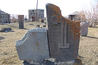
The town has been inhabited since the 7th century and has a khachkar dated 881, two shrines from the 12th and 13th centuries, and a 17th-century church.[1]
Demographics
The village had 3,132 inhabitants in 2011.[2]
Climate
| Climate data for Masrik, 1991-2020 | |||||||||||||
|---|---|---|---|---|---|---|---|---|---|---|---|---|---|
| Month | Jan | Feb | Mar | Apr | May | Jun | Jul | Aug | Sep | Oct | Nov | Dec | Year |
| Record high °C (°F) | 9.8 (49.6) | 10.5 (50.9) | 18.6 (65.5) | 25.0 (77.0) | 29.5 (85.1) | 31.3 (88.3) | 35.2 (95.4) | 34.5 (94.1) | 31.5 (88.7) | 25.0 (77.0) | 19.2 (66.6) | 15.6 (60.1) | 35.2 (95.4) |
| Daily mean °C (°F) | −8.3 (17.1) | −7.2 (19.0) | −1.4 (29.5) | 4.9 (40.8) | 9.5 (49.1) | 13.9 (57.0) | 16.9 (62.4) | 17.2 (63.0) | 13.5 (56.3) | 7.9 (46.2) | 0.5 (32.9) | −5.4 (22.3) | 5.2 (41.3) |
| Record low °C (°F) | −31.0 (−23.8) | −31.2 (−24.2) | −27.2 (−17.0) | −23.3 (−9.9) | −7.9 (17.8) | −1.8 (28.8) | 0.0 (32.0) | 1.4 (34.5) | −6.5 (20.3) | −10.0 (14.0) | −24.6 (−12.3) | −26.8 (−16.2) | −31.2 (−24.2) |
| Average precipitation mm (inches) | 19.7 (0.78) | 21.1 (0.83) | 33.8 (1.33) | 47.4 (1.87) | 64.0 (2.52) | 73.6 (2.90) | 45.4 (1.79) | 35.7 (1.41) | 37.2 (1.46) | 43.1 (1.70) | 30.3 (1.19) | 24.9 (0.98) | 476.2 (18.76) |
| Average precipitation days (≥ 1 mm) | 5 | 5.1 | 7 | 8.7 | 12.1 | 9.8 | 6.5 | 5.4 | 5.2 | 6.5 | 5.4 | 5.3 | 82 |
| Average relative humidity (%) | 71.8 | 70.7 | 68.5 | 65.9 | 65.4 | 64.4 | 62.8 | 61.5 | 62.9 | 66.6 | 70.2 | 72.3 | 66.9 |
| Source: NOAA[3] | |||||||||||||
Gallery
-
 House of Culture
 -
 Church in Mets Masrik
 -
 Khachkars in Mets Masrik
 -
 WWII monument
 -
 Khachkars in Mets Masrik
 -
 Church in Mets Masrik
 -
 Khachkars in Mets Masrik


References
- ^ a b Kiesling, Brady; Kojian, Raffi (2005). Rediscovering Armenia: Guide (2nd ed.). Yerevan: Matit Graphic Design Studio. p. 82. ISBN 99941-0-121-8.
- ^ Statistical Committee of Armenia. "The results of the 2011 Population Census of Armenia" (PDF).
- ^ "WMO Climate Normals for 1991-2020: Masrik" (CSV). ncei.noaa.gov (Excel). National Oceanic and Atmosoheric Administration. Retrieved 8 March 2024.
{{cite web}}: CS1 maint: postscript (link)
External links
Wikimedia Commons has media related to Cultural heritage monuments in Mets Masrik, Gegharkunik.
- Report of the results of the 2001 Armenian Census, Statistical Committee of Armenia
- Kiesling, Brady (June 2000). Rediscovering Armenia: An Archaeological/Touristic Gazetteer and Map Set for the Historical Monuments of Armenia (PDF). Archived (PDF) from the original on 6 November 2021.
- v
- t
- e

Capital: Gavar

- Akhpradzor
- Akunk
- Areguni
- Arpunk
- Avazan
- Ayrk
- Azat
- Daranak
- Geghakar
- Geghamabak
- Geghamasar
- Jaghatsadzor
- Kakhakn
- Karchaghbyur
- Khachaghbyur
- Kut
- Kutakan
- Lchavan
- Lusakunk
- Makenis
- Mets Masrik
- Nerkin Shorzha
- Norabak
- Norakert
- Pambak
- Pokr Masrik
- Shatjrek
- Shatvan
- Sotk
- Torfavan
- Tretuk
- Tsovak
- Vanevan
- Verin Shorzha
- Zariver
Portal:
 Geography

 | This article about a location in Gegharkunik Province, Armenia is a stub. You can help Wikipedia by expanding it. |
- v
- t
- e


