Mount Airy, Pittsylvania County, Virginia
Unincorporated community in Virginia, US
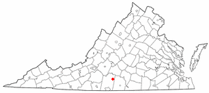
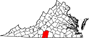
Mount Airy is an unincorporated community in northeastern Pittsylvania County, Virginia, United States. Its altitude is 643 feet (196 m), and it is located at 36°56′35″N 79°11′32″W / 36.94306°N 79.19222°W / 36.94306; -79.19222 (36.9429172, -79.1922420),[1] along State Route 40 between Gretna and Brookneal.[2] It is included in the Danville, Virginia Metropolitan Statistical Area.
References
- v
- t
- e
Municipalities and communities of Pittsylvania County, Virginia, United States
County seat: Chatham
- Chatham
- Gretna
- Hurt
- Blairs
- Motley
- Mount Hermon
communities
- Ajax
- Bachelors Hall
- Banister
- Brights
- Brosville
- Brutus
- Buford
- Callahans Hills
- Callands
- Cartersville
- Cascade
- Cedar Forest
- Cedar Hill
- Chalk Level
- Climax
- Coles Hill
- Dry Fork
- Dundee
- Ebenezer
- Flint Hill
- Galveston
- Glenland
- Glenwood
- Grady
- Green Acres
- Green Pond
- Greenfield
- Grit
- Henrys Mill
- Hermosa
- Hill Grove
- Hinesville
- Hollywood
- Hopewell
- Java
- Keeling
- Kentuck
- Lakewood
- Laniers Mill
- Laurel Grove
- Level Run
- Lucks
- Markham
- Motleys Mill
- Mt. Airy
- Mount Cross
- Mountain Hill
- Museville
- Natal
- Oak Hill
- Oak Ridge
- Peytonsburg
- Pickaway
- Pickerel
- Pittsville
- Pleasant Gap
- Pleasant Grove
- Pullens
- Ray
- Red Oak Hollow
- Redeye
- Renan
- Riceville
- Ridgeway
- Ringgold
- Rondo
- Sandy River
- Sharon
- Sheva
- Shockoe
- Soapstone
- Sonans
- Spring Garden
- Stony Mill
- Straightstone
- Sutherlin
- Swansonville
- Sycamore
- Tightsqueeze
- Toshes
- Transco Village
- Vance
- Vandola
- Weal
- West Fork
- Whitfield
- Whitmell
- Whittles
- Witt
- Woodlake Park
- Woodlawn
- Worlds
- Virginia portal
- United States portal
36°56′35″N 79°11′32″W / 36.94306°N 79.19222°W / 36.94306; -79.19222
 | This Pittsylvania County, Virginia state location article is a stub. You can help Wikipedia by expanding it. |
- v
- t
- e


