National Register of Historic Places listings in Montgomery County, Alabama

This is a list of the National Register of Historic Places listings in Montgomery County, Alabama.
This is intended to be a complete list of the properties and districts on the National Register of Historic Places in Montgomery County, Alabama, United States. Latitude and longitude coordinates are provided for many National Register properties and districts; these locations may be seen together in an online map.[1]
There are 65 properties and districts listed on the National Register in the county, including 4 National Historic Landmarks. One historic district once listed on the Register has been removed.
This National Park Service list is complete through NPS recent listings posted June 7, 2024.[2]
Map all coordinates using OpenStreetMap
Download coordinates as:
- KML
- GPX (all coordinates)
- GPX (primary coordinates)
- GPX (secondary coordinates)
Current listings
| [3] | Name on the Register | Image | Date listed[4] | Location | City or town | Description |
|---|---|---|---|---|---|---|
| 1 | Alabama State Capitol |  | October 15, 1966 (#66000152) | Goat Hill, eastern end of Dexter Ave. 32°22′41″N 86°18′02″W / 32.378°N 86.3005°W / 32.378; -86.3005 (Alabama State Capitol) | Montgomery | |
| 2 | Alabama State University Historic District |  | October 8, 1998 (#98001228) | 915 S. Jackson St. 32°21′51″N 86°17′51″W / 32.3642°N 86.2975°W / 32.3642; -86.2975 (Alabama State University Historic District) | Montgomery | |
| 3 | Bell Building |  | December 15, 1981 (#81000132) | 207 Montgomery St. 32°22′36″N 86°18′39″W / 32.3766°N 86.3107°W / 32.3766; -86.3107 (Bell Building) | Montgomery | |
| 4 | Brame House | Upload image | September 17, 1980 (#80000728) | 402-404 S. Hull St. 32°22′24″N 86°18′14″W / 32.3734°N 86.3039°W / 32.3734; -86.3039 (Brame House) | Montgomery | Building no longer at this location |
| 5 | Bricklayers Hall | Upload image | July 23, 2020 (#100005355) | 530 South Union St. 32°22′17″N 86°17′59″W / 32.3713°N 86.2996°W / 32.3713; -86.2996 (Bricklayers Hall) | Montgomery | |
| 6 | Patrick Henry Brittan House |  | December 13, 1979 (#79000393) | 507 Columbus St. 32°22′57″N 86°18′08″W / 32.38241°N 86.30227°W / 32.38241; -86.30227 (Patrick Henry Brittan House) | Montgomery | |
| 7 | Building 800-Austin Hall |  | March 2, 1988 (#87002178) | 2nd St. at Maxwell Air Force Base 32°22′42″N 86°21′03″W / 32.3783°N 86.3508°W / 32.3783; -86.3508 (Building 800-Austin Hall) | Montgomery | |
| 8 | Building 836-Community College of the Air Force Building |  | March 2, 1988 (#87002182) | Maxwell Boulevard at Maxwell Air Force Base 32°22′49″N 86°21′07″W / 32.3804°N 86.3519°W / 32.3804; -86.3519 (Building 836-Community College of the Air Force Building) | Montgomery | |
| 9 | Cassimus House | 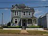 | August 13, 1976 (#76000349) | 110 N. Jackson St. 32°22′43″N 86°17′47″W / 32.3786°N 86.2964°W / 32.3786; -86.2964 (Cassimus House) | Montgomery | |
| 10 | City of St. Jude Historic District |  | June 18, 1990 (#90000916) | 2048 W. Fairview Ave. 32°21′10″N 86°19′37″W / 32.3528°N 86.3269°W / 32.3528; -86.3269 (City of St. Jude Historic District) | Montgomery | |
| 11 | Cleveland Court Apartments 620–638 |  | October 29, 2001 (#01001167) | 620-638 Cleveland Ct. 32°21′49″N 86°19′04″W / 32.3635°N 86.3178°W / 32.3635; -86.3178 (Cleveland Court Apartments 620–638) | Montgomery | |
| 12 | Cloverdale Historic District |  | September 12, 1985 (#85002161) | Roughly bounded by Norman Bridge and Cloverdale Rd., Fairview and Felder Aves. and Boultier St. 32°21′18″N 86°17′42″W / 32.355°N 86.295°W / 32.355; -86.295 (Cloverdale Historic District) | Montgomery | |
| 13 | Cottage Hill Historic District |  | November 7, 1976 (#76000350) | Roughly bounded by Goldthwaite, Bell, Holt, and Clayton Sts. 32°22′29″N 86°19′05″W / 32.3747°N 86.3181°W / 32.3747; -86.3181 (Cottage Hill Historic District) | Montgomery | |
| 14 | Court Square Historic District |  | March 1, 1982 (#82002062) | 21-35 Court St., 1-2 Dexter Ave., 18-24 N. Court St., and Court Sq.; also roughly Dexter Ave. and Perry, Court, and Monroe Sts. 32°22′38″N 86°18′32″W / 32.3772°N 86.3089°W / 32.3772; -86.3089 (Court Square Historic District) | Montgomery | Second set of boundaries represents a boundary increase, the Court Square-Dexter Avenue Historic District Boundary Increase, listed on August 30, 1984 |
| 15 | Jefferson Davis Hotel |  | March 13, 1979 (#75000324) | Catoma and Montgomery Sts. 32°22′33″N 86°18′45″W / 32.3758°N 86.3125°W / 32.3758; -86.3125 (Jefferson Davis Hotel) | Montgomery | |
| 16 | Dexter Avenue Baptist Church |  | July 1, 1974 (#74000431) | 454 Dexter Ave. 32°22′38″N 86°18′10″W / 32.3773°N 86.3027°W / 32.3773; -86.3027 (Dexter Avenue Baptist Church) | Montgomery | |
| 17 | Dowe Historic District | 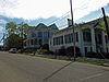 | December 29, 1988 (#88003076) | 320 and 334 Washington Ave. and 114-116 S. Hull St. 32°22′34″N 86°18′14″W / 32.3761°N 86.3039°W / 32.3761; -86.3039 (Dowe Historic District) | Montgomery | |
| 18 | Edgewood |  | April 24, 1973 (#73000367) | 3175 Thomas Ave. 32°20′48″N 86°17′12″W / 32.3468°N 86.2866°W / 32.3468; -86.2866 (Edgewood) | Montgomery | |
| 19 | First White House of the Confederacy |  | June 25, 1974 (#74000432) | 644 Washington Ave. 32°22′34″N 86°18′00″W / 32.37618°N 86.2999°W / 32.37618; -86.2999 (First White House of the Confederacy) | Montgomery | |
| 20 | Garden District |  | September 13, 1984 (#84000698) | Roughly bounded by Norman Bridge Rd., Court St., and Jeff Davis and Fairview Aves. 32°21′29″N 86°18′19″W / 32.3581°N 86.3053°W / 32.3581; -86.3053 (Garden District) | Montgomery | |
| 21 | Gay House |  | March 15, 1975 (#75000325) | 230 Noble Ave. 32°21′46″N 86°18′17″W / 32.3629°N 86.3048°W / 32.3629; -86.3048 (Gay House) | Montgomery | Destroyed by fire in 2007. |
| 22 | Gerald-Dowdell House | 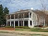 | April 28, 1980 (#80000729) | 405 S. Hull St. 32°22′25″N 86°18′12″W / 32.37349°N 86.3033°W / 32.37349; -86.3033 (Gerald-Dowdell House) | Montgomery | |
| 23 | Governor's Mansion |  | July 3, 1972 (#72000172) | 1142 S. Perry St. 32°21′43″N 86°18′27″W / 32.36192°N 86.30739°W / 32.36192; -86.30739 (Governor's Mansion) | Montgomery | |
| 24 | Grace Episcopal Church | 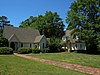 | February 19, 1982 (#82002067) | 906 Pike Rd. 32°21′18″N 86°05′51″W / 32.3551°N 86.09737°W / 32.3551; -86.09737 (Grace Episcopal Church) | Mount Meigs | |
| 25 | Grove Court Apartments |  | December 11, 2013 (#13000894) | 559 S. Court St. 32°22′14″N 86°18′30″W / 32.370474°N 86.308327°W / 32.370474; -86.308327 (Grove Court Apartments) | Montgomery | |
| 26 | Harrington Archaeological Site | Upload image | January 25, 1979 (#79000394) | Address Restricted | Montgomery | |
| 27 | Huntingdon College Campus Historic District |  | February 24, 2000 (#00000138) | 1500 E. Fairview Ave. 32°20′59″N 86°17′06″W / 32.349722°N 86.285°W / 32.349722; -86.285 (Huntingdon College Campus Historic District) | Montgomery | |
| 28 | Jefferson Franklin Jackson House |  | May 17, 1984 (#84000711) | 409 S. Union St. 32°22′25″N 86°17′56″W / 32.37348°N 86.29894°W / 32.37348; -86.29894 (Jefferson Franklin Jackson House) | Montgomery | |
| 29 | Gov. Thomas G. Jones House |  | December 8, 1978 (#78000506) | 323 Adams Ave. 32°22′32″N 86°18′14″W / 32.37545°N 86.30384°W / 32.37545; -86.30384 (Gov. Thomas G. Jones House) | Montgomery | |
| 30 | Lower Commerce Street Historic District |  | March 29, 1979 (#79000395) | Roughly bounded by railroad tracks, Commerce, N. Court, and Bibb Sts.; also roughly bounded by railroad tracks, N. Court, Commerce, Coosa, and Tallapoosa Sts; also roughly bounded by the former Central of Georgia railroad tracks, N. Lawrence St., Madison Ave., and Commerce St. 32°22′49″N 86°18′38″W / 32.380278°N 86.310556°W / 32.380278; -86.310556 (Lower Commerce Street Historic District) | Montgomery | Second and third sets of boundaries represent boundary increases of February 25, 1982 and January 15, 1987 |
| 31 | Maxwell Air Force Base Senior Officers' Quarters Historic District |  | March 2, 1988 (#87002177) | West Dr., N. Juniper and S. Juniper Sts., Inner Circle, Center Dr., Sequoia, and East Dr. at Maxwell Air Force Base 32°22′51″N 86°20′24″W / 32.380833°N 86.34°W / 32.380833; -86.34 (Maxwell Air Force Base Senior Officers' Quarters Historic District) | Montgomery | |
| 32 | McBryde-Screws-Tyson House |  | November 28, 1980 (#80000730) | 433 Mildred St. 32°22′14″N 86°18′54″W / 32.37052°N 86.3151°W / 32.37052; -86.3151 (McBryde-Screws-Tyson House) | Montgomery | |
| 33 | Montgomery Greyhound Bus Station |  | May 16, 2011 (#11000298) | 210 S. Court St. 32°22′29″N 86°18′33″W / 32.37464°N 86.30912°W / 32.37464; -86.30912 (Montgomery Greyhound Bus Station) | Montgomery | Site of a clash between Freedom Riders and protesters in 1961. Today serves as a museum for the Civil Rights Movement. |
| 34 | Montgomery Union Station and Trainshed |  | July 24, 1973 (#73000368) | Water St. 32°22′50″N 86°18′51″W / 32.38053°N 86.31406°W / 32.38053; -86.31406 (Montgomery Union Station and Trainshed) | Montgomery | |
| 35 | Montgomery Veterans Administration Hospital Historic District |  | March 19, 2012 (#12000141) | 215 Perry Hill Rd. 32°22′39″N 86°14′46″W / 32.377406°N 86.24622°W / 32.377406; -86.24622 (Montgomery Veterans Administration Hospital Historic District) | Montgomery | part of the United States Second Generation Veterans Hospitals Multiple Property Submission |
| 36 | Mt. Zion AME Zion Church | 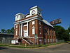 | October 4, 2002 (#02001066) | 467 Holt St. 32°22′06″N 86°19′14″W / 32.36839°N 86.32052°W / 32.36839; -86.32052 (Mt. Zion AME Zion Church) | Montgomery | |
| 37 | Muklassa | Upload image | August 28, 1973 (#73000369) | Address Restricted | Montgomery | |
| 38 | The Murphy House | 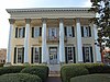 | March 24, 1972 (#72000173) | 22 Bibb St. 32°22′48″N 86°18′35″W / 32.38006°N 86.30964°W / 32.38006; -86.30964 (The Murphy House) | Montgomery | |
| 39 | Old Ship African Methodist Episcopal Zion Church |  | January 24, 1991 (#90002177) | 483 Holcombe St. 32°22′17″N 86°18′42″W / 32.3714°N 86.31169°W / 32.3714; -86.31169 (Old Ship African Methodist Episcopal Zion Church) | Montgomery | |
| 40 | Opp Cottage |  | May 4, 1976 (#76000351) | 33 W. Jefferson Davis Ave. 32°21′58″N 86°18′36″W / 32.36603°N 86.30994°W / 32.36603; -86.30994 (Opp Cottage) | Montgomery | |
| 41 | Ordeman-Shaw Historic District |  | May 13, 1971 (#71000105) | Bounded by McDonough, Decatur, Madison, and Randolph Sts. 32°22′54″N 86°18′14″W / 32.381667°N 86.303889°W / 32.381667; -86.303889 (Ordeman-Shaw Historic District) | Montgomery | |
| 42 | Pastorium, Dexter Avenue Baptist Church | 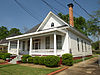 | March 10, 1982 (#82002064) | 309 S. Jackson St. 32°22′23″N 86°17′46″W / 32.37304°N 86.29605°W / 32.37304; -86.29605 (Pastorium, Dexter Avenue Baptist Church) | Montgomery | |
| 43 | Pepperman House | 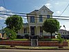 | March 1, 1982 (#82002065) | 17 Mildred St. 32°22′15″N 86°18′35″W / 32.370833°N 86.309722°W / 32.370833; -86.309722 (Pepperman House) | Montgomery | |
| 44 | Perry Street Historic District |  | December 16, 1971 (#71000106) | Roughly bounded by McDonough St. on the east, Sayre St. on the west, Washington St. on the north, and Donaldson St. on the south 32°22′26″N 86°18′27″W / 32.373889°N 86.3075°W / 32.373889; -86.3075 (Perry Street Historic District) | Montgomery | |
| 45 | Powder Magazine |  | April 13, 1973 (#73000370) | End of Eugene St. 32°22′53″N 86°19′41″W / 32.381389°N 86.328056°W / 32.381389; -86.328056 (Powder Magazine) | Montgomery | American Civil War-era building for gunpowder storage. Located in Powder Magazine Park, the building is currently under restoration. |
| 46 | St. John's Episcopal Church | 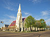 | February 24, 1975 (#75000326) | 113 Madison Ave. 32°22′49″N 86°18′26″W / 32.38017°N 86.30735°W / 32.38017; -86.30735 (St. John's Episcopal Church) | Montgomery | |
| 47 | Sayre Street School |  | February 19, 1982 (#82002066) | 506 Sayre St. 32°22′15″N 86°18′39″W / 32.37076°N 86.31079°W / 32.37076; -86.31079 (Sayre Street School) | Montgomery | |
| 48 | Scott Street Firehouse | 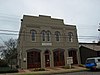 | February 12, 1981 (#81000133) | 418 Scott St. 32°22′25″N 86°18′11″W / 32.37349°N 86.30301°W / 32.37349; -86.30301 (Scott Street Firehouse) | Montgomery | |
| 49 | Semple House | 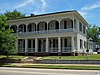 | September 27, 1972 (#72000174) | S. Court & High Sts. 32°22′19″N 86°18′31″W / 32.37202°N 86.3086°W / 32.37202; -86.3086 (Semple House) | Montgomery | |
| 50 | Shepherd Building |  | May 22, 1986 (#86001106) | 312 Montgomery St. 32°22′34″N 86°18′43″W / 32.3762°N 86.31199°W / 32.3762; -86.31199 (Shepherd Building) | Montgomery | Demolished in 2010.[5] |
| 51 | Jere Shine Site | Upload image | December 8, 1978 (#78000507) | Address Restricted | Montgomery | |
| 52 | Smith-Joseph-Stratton House | 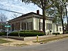 | April 11, 1985 (#85000736) | 302 Alabama St. 32°22′26″N 86°18′17″W / 32.37392°N 86.30459°W / 32.37392; -86.30459 (Smith-Joseph-Stratton House) | Montgomery | |
| 53 | South Perry Street Historic District |  | August 30, 1984 (#84000713) | Roughly Perry St. between Washington St. and Dexter Ave. 32°22′36″N 86°18′27″W / 32.376667°N 86.3075°W / 32.376667; -86.3075 (South Perry Street Historic District) | Montgomery | |
| 54 | Stay House |  | September 10, 1979 (#79000396) | 631 S. Hull St 32°22′10″N 86°18′11″W / 32.36943°N 86.30318°W / 32.36943; -86.30318 (Stay House) | Montgomery | |
| 55 | Steiner-Lobman and Teague Hardware Buildings |  | January 31, 1979 (#79000397) | 184 and 172 Commerce St. 32°22′49″N 86°18′41″W / 32.38024°N 86.31144°W / 32.38024; -86.31144 (Steiner-Lobman and Teague Hardware Buildings) | Montgomery | |
| 56 | Stone Plantation |  | December 31, 2001 (#01001411) | 5001 Old Selma Rd. 32°21′02″N 86°25′31″W / 32.35067°N 86.4254°W / 32.35067; -86.4254 (Stone Plantation) | Montgomery | |
| 57 | Tankersley Rosenwald School |  | January 22, 2009 (#08001332) | 10 miles (16 km) south of Montgomery on U.S. Route 31 to Pettus Rd. to School Spur on the western side 32°08′32″N 86°21′25″W / 32.14231°N 86.35685°W / 32.14231; -86.35685 (Tankersley Rosenwald School) | Hope Hull | |
| 58 | Dr. C.A. Thigpen House |  | December 13, 1977 (#77000215) | 1412 S. Perry St. 32°21′33″N 86°18′26″W / 32.35924°N 86.30729°W / 32.35924; -86.30729 (Dr. C.A. Thigpen House) | Montgomery | |
| 59 | Tulane Building |  | March 21, 1979 (#79000398) | 800 High St. 32°22′19″N 86°17′52″W / 32.37191°N 86.29767°W / 32.37191; -86.29767 (Tulane Building) | Montgomery | |
| 60 | Tyson-Maner House | 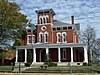 | May 10, 1979 (#79000399) | 469 S. McDonough St. 32°22′20″N 86°18′16″W / 32.37213°N 86.30441°W / 32.37213; -86.30441 (Tyson-Maner House) | Montgomery | |
| 61 | United States Post Office and Courthouse-Montgomery |  | June 3, 1998 (#98000611) | Church St. between Moulton and Lee Sts. 32°22′30″N 86°18′34″W / 32.37507°N 86.30958°W / 32.37507; -86.30958 (United States Post Office and Courthouse-Montgomery) | Montgomery | Many important civil rights cases heard and decided in this 1933 building |
| 62 | Wharton-Chappell House |  | July 19, 2016 (#16000445) | 1020 Maxwell Blvd. 32°22′40″N 86°19′43″W / 32.3778°N 86.32868°W / 32.3778; -86.32868 (Wharton-Chappell House) | Montgomery | |
| 63 | Winter Building |  | January 14, 1972 (#72000175) | 2 Dexter Ave. 32°22′38″N 86°18′32″W / 32.3771°N 86.30881°W / 32.3771; -86.30881 (Winter Building) | Montgomery | |
| 64 | Winter Place |  | May 31, 2006 (#06000439) | 454 S. Goldthwaite St. 32°22′17″N 86°18′57″W / 32.37136°N 86.31584°W / 32.37136; -86.31584 (Winter Place) | Montgomery | |
| 65 | William Lowndes Yancey Law Office |  | November 7, 1973 (#73000371) | Washington and Perry Sts. 32°22′35″N 86°18′26″W / 32.37644°N 86.30712°W / 32.37644; -86.30712 (William Lowndes Yancey Law Office) | Montgomery |
Former listings
| [3] | Name on the Register | Image | Date listed | Date removed | Location | City or town | Description |
|---|---|---|---|---|---|---|---|
| 1 | North Lawrence-Monroe Street Historic District | Upload image | August 30, 1984 (#84000712) | October 6, 2011 | 132-148, 216, and 220 Monroe St. and 14, 22, 28-40, and 56 N. Lawrence St. 32°22′41″N 86°18′21″W / 32.3781°N 86.3058°W / 32.3781; -86.3058 (North Lawrence-Monroe Street Historic District) | Montgomery |
See also
- List of National Historic Landmarks in Alabama
- National Register of Historic Places listings in Alabama
References
Wikimedia Commons has media related to National Register of Historic Places in Montgomery, Alabama.
- ^ The latitude and longitude information provided in this table was derived originally from the National Register Information System, which has been found to be fairly accurate for about 99% of listings. Some locations in this table may have been corrected to current GPS standards.
- ^ National Park Service, United States Department of the Interior, "National Register of Historic Places: Weekly List Actions", retrieved June 7, 2024.
- ^ a b Numbers represent an alphabetical ordering by significant words. Various colorings, defined here, differentiate National Historic Landmarks and historic districts from other NRHP buildings, structures, sites or objects.
- ^ The eight-digit number below each date is the number assigned to each location in the National Register Information System database, which can be viewed by clicking the number.
- ^ "Executive Building to be demolished at TROY Montgomery Campus". Retrieved 23 April 2017.
- v
- t
- e
by county
- Autauga
- Baldwin
- Barbour
- Bibb
- Blount
- Bullock
- Butler
- Calhoun
- Chambers
- Cherokee
- Chilton
- Choctaw
- Clarke
- Clay
- Cleburne
- Coffee
- Colbert
- Conecuh
- Coosa
- Covington
- Crenshaw
- Cullman
- Dale
- Dallas
- DeKalb
- Elmore
- Escambia
- Etowah
- Fayette
- Franklin
- Geneva
- Greene
- Hale
- Henry
- Houston
- Jackson
- Jefferson
- Lamar
- Lauderdale
- Lawrence
- Lee
- Limestone
- Lowndes
- Macon
- Madison
- Marengo
- Marion
- Marshall
- Mobile
- Monroe
- Montgomery
- Morgan
- Perry
- Pickens
- Pike
- Randolph
- Russell
- St. Clair
- Shelby
- Sumter
- Talladega
- Tallapoosa
- Tuscaloosa
- Walker
- Washington
- Wilcox
- Winston


Municipalities and communities of Montgomery County, Alabama, United States | ||
|---|---|---|
County seat: Montgomery | ||
| Cities | 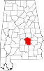 | |
| Towns | ||
| Unincorporated communities | ||
| Indian reservation | ||
| Footnotes | ‡This populated place also has portions in an adjacent county or counties | |
| ||


