National Register of Historic Places listings in Portsmouth, Virginia

This is a list of the National Register of Historic Places listings in Portsmouth, Virginia.
This is intended to be a complete list of the properties and districts on the National Register of Historic Places in the independent city of Portsmouth, Virginia, United States. The locations of National Register properties and districts for which the latitude and longitude coordinates are included below, may be seen in an online map.[1]
There are 23 properties and districts listed on the National Register in the city, including 2 National Historic Landmarks. Another property was once listed but has been removed.
This National Park Service list is complete through NPS recent listings posted May 31, 2024.[2]
Map all coordinates using OpenStreetMap
Download coordinates as:
- KML
- GPX (all coordinates)
- GPX (primary coordinates)
- GPX (secondary coordinates)
Current listings
| [3] | Name on the Register[4] | Image | Date listed[5] | Location | Description |
|---|---|---|---|---|---|
| 1 | Abigarlos |  | May 21, 2019 (#100003975) | 3321 Carney Farm Ln. 36°51′02″N 76°22′16″W / 36.850556°N 76.371111°W / 36.850556; -76.371111 (Abigarlos) | |
| 2 | Cedar Grove Cemetery |  | October 15, 1992 (#92001366) | 301 Fort Ln. 36°50′20″N 76°18′29″W / 36.838889°N 76.308056°W / 36.838889; -76.308056 (Cedar Grove Cemetery) | |
| 3 | Commodore Theatre | 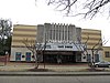 | February 27, 1997 (#97000203) | 421 High St. 36°50′06″N 76°18′07″W / 36.835000°N 76.301944°W / 36.835000; -76.301944 (Commodore Theatre) | |
| 4 | Confederate Monument |  | September 4, 1997 (#97000956) | Junction of High and Court Sts. 36°50′08″N 76°18′03″W / 36.835611°N 76.300889°W / 36.835611; -76.300889 (Confederate Monument) | |
| 5 | Craddock Historic District |  | June 20, 1974 (#74002240) | Bounded by Paradise Creek, Victory Boulevard, and the George Washington Highway 36°48′07″N 76°19′04″W / 36.801944°N 76.317778°W / 36.801944; -76.317778 (Craddock Historic District) | |
| 6 | Downtown Portsmouth Historic District | 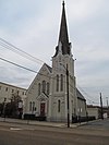 | January 16, 2004 (#03001485) | Roughly bounded by Interstate 264, Middle St., Primrose St., and Queen St. 36°50′07″N 76°18′14″W / 36.835278°N 76.303889°W / 36.835278; -76.303889 (Downtown Portsmouth Historic District) | |
| 7 | Drydock No. 1 |  | February 26, 1970 (#70000862) | Norfolk Naval Shipyard 36°49′14″N 76°17′35″W / 36.820556°N 76.293056°W / 36.820556; -76.293056 (Drydock No. 1) | |
| 8 | Fort Nelson Chapter of the Daughters of the American Revolution Chapter House |  | August 8, 2007 (#07000805) | 506 Westmoreland Ave. 36°50′00″N 76°21′49″W / 36.833333°N 76.363611°W / 36.833333; -76.363611 (Fort Nelson Chapter of the Daughters of the American Revolution Chapter House) | |
| 9 | LIGHTSHIP No. 101, PORTSMOUTH | 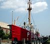 | May 5, 1989 (#89001080) | London Slip, Elizabeth River 36°50′13″N 76°17′46″W / 36.836944°N 76.296111°W / 36.836944; -76.296111 (LIGHTSHIP No. 101, PORTSMOUTH) | |
| 10 | Monumental Methodist Church | 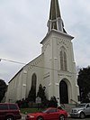 | January 15, 2004 (#03001430) | 450 Dinwiddie St. 36°50′09″N 76°18′10″W / 36.835833°N 76.302778°W / 36.835833; -76.302778 (Monumental Methodist Church) | |
| 11 | Park View Historic District |  | October 4, 1984 (#84000047) | Roughly bounded by Elm and Parkview Aves., Fort Lane, Blair, and Harrell Sts. 36°50′31″N 76°18′40″W / 36.841944°N 76.311111°W / 36.841944; -76.311111 (Park View Historic District) | |
| 12 | Port Norfolk Historic District |  | September 30, 1983 (#83003299) | Roughly bounded by Bayview Boulevard, Chatauqua Ave., Hartford St., Douglas Ave., and Hull Creek 36°50′54″N 76°20′14″W / 36.848333°N 76.337222°W / 36.848333; -76.337222 (Port Norfolk Historic District) | |
| 13 | Portsmouth Community Library |  | August 12, 2010 (#10000544) | 906 Elm St. 36°49′55″N 76°18′47″W / 36.831806°N 76.313056°W / 36.831806; -76.313056 (Portsmouth Community Library) | |
| 14 | Portsmouth Courthouse |  | April 29, 1970 (#70000876) | Northwestern corner of Court and High Sts. 36°50′08″N 76°18′05″W / 36.835556°N 76.301389°W / 36.835556; -76.301389 (Portsmouth Courthouse) | |
| 15 | Portsmouth Naval Hospital |  | April 13, 1972 (#72001516) | On Hospital Point at Washington and Crawford Sts. 36°50′50″N 76°18′19″W / 36.847222°N 76.305278°W / 36.847222; -76.305278 (Portsmouth Naval Hospital) | |
| 16 | Portsmouth Olde Towne Historic District |  | September 8, 1970 (#70000877) | Bounded by Crawford Parkway, London St., the Elizabeth River, and extending 0.1 miles west of Washington St.; also Grace and Queen Sts. 36°50′20″N 76°18′07″W / 36.838889°N 76.301944°W / 36.838889; -76.301944 (Portsmouth Olde Towne Historic District) | Grace and Queen represent a boundary increase of October 6, 1983 |
| 17 | Pythian Castle |  | October 30, 1980 (#80004316) | 610-612 Court St. 36°50′02″N 76°18′04″W / 36.833889°N 76.301111°W / 36.833889; -76.301111 (Pythian Castle) | |
| 18 | Quarters A, B, and C, Norfolk Naval Shipyard | 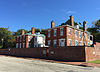 | December 19, 1974 (#74002242) | Norfolk Naval Shipyard 36°49′36″N 76°17′51″W / 36.826667°N 76.297500°W / 36.826667; -76.297500 (Quarters A, B, and C, Norfolk Naval Shipyard) | |
| 19 | St. Paul's Catholic Church |  | June 6, 2002 (#02000619) | 518 High St. 36°50′08″N 76°18′13″W / 36.835556°N 76.303611°W / 36.835556; -76.303611 (St. Paul's Catholic Church) | |
| 20 | Seaboard Coastline Building |  | October 10, 1985 (#85003129) | 1 High St. 36°50′06″N 76°17′48″W / 36.835000°N 76.296667°W / 36.835000; -76.296667 (Seaboard Coastline Building) | |
| 21 | Shea Terrace Elementary School |  | September 14, 2002 (#02001002) | 253 Constitution Ave. 36°50′23″N 76°19′29″W / 36.839722°N 76.324722°W / 36.839722; -76.324722 (Shea Terrace Elementary School) | |
| 22 | Trinity Episcopal Church | 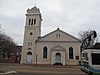 | May 14, 1973 (#73002219) | High and Court Sts. 36°50′06″N 76°18′04″W / 36.835000°N 76.301111°W / 36.835000; -76.301111 (Trinity Episcopal Church) | |
| 23 | Truxtun Historic District |  | September 16, 1982 (#82004581) | Portsmouth and Deep Creek Boulevards and Manly, Dahlia, Hobson, Dewey, and Bagley Sts. 36°48′59″N 76°19′48″W / 36.816389°N 76.330000°W / 36.816389; -76.330000 (Truxtun Historic District) |
Former listing
| [3] | Name on the Register | Image | Date listed | Date removed | Location | Description |
|---|---|---|---|---|---|---|
| 1 | The Circle |  | March 8, 2006 (#06000120) | February 7, 2017 | 3010 High St. 36°50′05″N 76°20′18″W / 36.834722°N 76.338333°W / 36.834722; -76.338333 (The Circle) | Demolished in August 2013 |
See also
Wikimedia Commons has media related to National Register of Historic Places in Portsmouth, Virginia.
- List of National Historic Landmarks in Virginia
- National Register of Historic Places listings in Virginia
References
- ^ The latitude and longitude information provided in this table was derived originally from the National Register Information System, which has been found to be fairly accurate for about 99% of listings. Some locations in this table may have been corrected to current GPS standards.
- ^ National Park Service, United States Department of the Interior, "National Register of Historic Places: Weekly List Actions", retrieved May 31, 2024.
- ^ a b Numbers represent an alphabetical ordering by significant words. Various colorings, defined here, differentiate National Historic Landmarks and historic districts from other NRHP buildings, structures, sites or objects.
- ^ "National Register Information System". National Register of Historic Places. National Park Service. April 24, 2008.
- ^ The eight-digit number below each date is the number assigned to each location in the National Register Information System database, which can be viewed by clicking the number.
- v
- t
- e
by county
- Accomack
- Albemarle
- Alleghany
- Amelia
- Amherst
- Appomattox
- Arlington
- Augusta
- Bath
- Bedford
- Bland
- Botetourt
- Brunswick
- Buchanan
- Buckingham
- Campbell
- Caroline
- Carroll
- Charles City
- Charlotte
- Chesterfield
- Clarke
- Craig
- Culpeper
- Cumberland
- Dickenson
- Dinwiddie
- Essex
- Fairfax
- Fauquier
- Floyd
- Fluvanna
- Franklin
- Frederick
- Giles
- Gloucester
- Goochland
- Grayson
- Greene
- Greensville
- Halifax
- Hanover
- Henrico
- Henry
- Highland
- Isle Of Wight
- James City
- King and Queen
- King George
- King William
- Lancaster
- Lee
- Loudoun
- Louisa
- Lunenburg
- Madison
- Mathews
- Mecklenburg
- Middlesex
- Montgomery
- Nelson
- New Kent
- Northampton
- Northumberland
- Nottoway
- Orange
- Page
- Patrick
- Pittsylvania
- Powhatan
- Prince Edward
- Prince George
- Prince William
- Pulaski
- Rappahannock
- Richmond
- Roanoke
- Rockbridge
- Rockingham
- Russell
- Scott
- Shenandoah
- Smyth
- Southampton
- Spotsylvania
- Stafford
- Surry
- Sussex
- Tazewell
- Warren
- Washington
- Westmoreland
- Wise
- Wythe
- York

by city
- Alexandria
- Bristol
- Buena Vista
- Charlottesville
- Chesapeake
- Colonial Heights
- Covington
- Danville
- Emporia
- Fairfax
- Falls Church
- Franklin
- Fredericksburg
- Galax
- Hampton
- Harrisonburg
- Hopewell
- Lexington
- Lynchburg
- Manassas
- Manassas Park
- Martinsville
- Newport News
- Norfolk
- Norton
- Petersburg
- Poquoson (no listings)
- Portsmouth
- Radford
- Richmond
- Roanoke
- Salem
- Staunton
- Suffolk
- Virginia Beach
- Waynesboro
- Williamsburg
- Winchester


