Noord-Sleen
Village in Drenthe, Netherlands
52°47′30″N 6°48′6″E / 52.79167°N 6.80167°E / 52.79167; 6.80167 (2021)[1]
7846[1]
Noord-Sleen is a village in the municipality of Coevorden in the province of Drenthe, Northeastern Netherlands.
Noord-Sleen started as an esdorp which split from Sleen in the 9th century. It contains two village greens.[3] It was first mentioned in 1365 as van Nortslene.[4] In 1840, it was home to 350 people.[5] The gristmill Albertdina was moved to Noord-Sleen in 1905.[6]
There are two dolmen near Noord-Sleen. D50 [nl] is a large dolmen with a near complete ring of 24 stones. 7 of the 8 capstones are still present.[7] D51 [nl] is not in a good condition, and it is clear that the capstones have been removed.[8]
Gallery
-
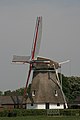 Windmill Albertdina
 -
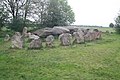 Dolmen D50


References
- ^ a b c "Kerncijfers wijken en buurten 2021". Central Bureau of Statistics. Retrieved 13 March 2022.
Two entries
- ^ "Postcodetool for 7846AA". Actueel Hoogtebestand Nederland (in Dutch). Het Waterschapshuis. Retrieved 13 March 2022.
- ^ Ronald Stenvert (2001). Sleen (in Dutch). Zwolle: Waanders. p. 159. ISBN 90 400 9454 3. Retrieved 13 March 2022.
- ^ "Noord-Sleen - (geografische naam)". Etymologiebank (in Dutch). Retrieved 13 March 2022.
- ^ "Noord-Sleen". Plaatsengids (in Dutch). Retrieved 13 March 2022.
- ^ "Apollo/ Molen van Grashuis". Molendatabase (in Dutch). Retrieved 13 March 2022.
- ^ "D50". Hunebedden (in Dutch). Retrieved 13 March 2022.
- ^ "D51". Hunebedden (in Dutch). Retrieved 13 March 2022.
Wikimedia Commons has media related to Noord-Sleen.
 | This Drenthe location article is a stub. You can help Wikipedia by expanding it. |
- v
- t
- e


