Pryazovia
Northern coastal region of the Sea of Azov
You can help expand this article with text translated from the corresponding article in Ukrainian. (March 2024) Click [show] for important translation instructions.
- Machine translation, like DeepL or Google Translate, is a useful starting point for translations, but translators must revise errors as necessary and confirm that the translation is accurate, rather than simply copy-pasting machine-translated text into the English Wikipedia.
- Consider adding a topic to this template: there are already 303 articles in the main category, and specifying
|topic=will aid in categorization. - Do not translate text that appears unreliable or low-quality. If possible, verify the text with references provided in the foreign-language article.
- You must provide copyright attribution in the edit summary accompanying your translation by providing an interlanguage link to the source of your translation. A model attribution edit summary is
Content in this edit is translated from the existing Ukrainian Wikipedia article at [[:uk:Північне Приазов'я]]; see its history for attribution. - You may also add the template
{{Translated|uk|Північне Приазов'я}}to the talk page. - For more guidance, see Wikipedia:Translation.
Place
- From top, left to right: Mariupol
- Melitopol
- Berdiansk State Pedagogical University in Berdiansk
- Alferaki Palace in Taganrog

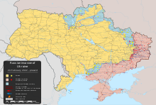
Approximate location of Pryazovia.
Legend: Приозів'я - Pryazovia; Озівське море - Sea of Azov; Чорне море - Black Sea
Legend: Приозів'я - Pryazovia; Озівське море - Sea of Azov; Чорне море - Black Sea
Russia
Pryazovia (Ukrainian: Приазов'я, sometimes spelled Приозів'я,[a] Pryozivia; Russian: Приазовье, romanized: Priazovye) or literally Cis-Azov region is usually used to refer to the geographic area of the north coast of the Sea of Azov,[1] mostly located in south-eastern Ukraine, with a small part in Russia. It is located in the southern part of the Azov-Kuban Lowland within the East European Plain, which surrounds the Sea of Azov for most of the stretch of coastline. In a more general sense it may mean the Azov Sea littoral, and conversely, to be more specific, it may also be referred to as the Northern Priazovye.
Geography

The (Northern) Priazovye consists of the southern parts of Donetsk Oblast and Zaporizhzhia Oblast and the eastern part of Kherson Oblast - parts of Ukraine and the western part of Rostov Oblast of Russia.
It is a small part in the south of the vast East European Plain.The southern edge of the Ukrainian Shield overlaps with Eastern Pryazovia. The natural Northern borders of Northwestern Pryazovia are the Azov Upland and the Donets Ridge.
Major rivers include Kalmius and Mius.
Largest cities are Rostov-on-Don, Mariupol, Taganrog, Melitopol and Berdiansk.
History
In its earlier history, the region was ruled by Scythia, Old Great Bulgaria, Khazars, Kipchaks, the Mongol Empire, and the Crimean Khanate. The oldest towns were located at present-day Taganrog, that is the ancient Greek emporium Kremnoi from the 7th to 5th centuries BC[2] and the medieval Italian Pisan colony of Portus Pisanus from the 13th century.[3][4] Following annexation and liquidation of Crimean Khanate, between 1783 and 1802 this land was part of Imperial Russian Novorossiya Governorate in the historical area of Novorossiya ("New Russia"). Tsarist Russia forcibly resettled many Greeks from Crimea to Pryazovia, as well as some Poles from territories annexed in the Partitions of Poland,[5] yet Ukrainians formed the majority of the population. After the fall of Tsarist Russia, the area was at various times either entirely or partly controlled by the Bolsheviks, Ukrainians, White Russians and Ukrainian Makhnovists, before the bulk of it became part of Soviet Ukraine. In 1924, a small portion with Taganrog in the east passed from Soviet Ukraine to Soviet Russia. During World War II, the territory was occupied by Germany in 1941–1943.
During the 2022 Russian invasion of Ukraine, the whole of Pryazovia was occupied by Russian troops. The most fierce battle in the area was the Siege of Mariupol.
Population
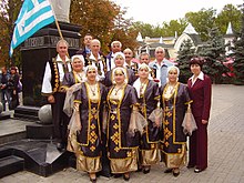
Ukraine's Greek minority population of 91,000 (in 2021) live mostly in the Pryazovia region, as a result of the Emigration of Christians from the Crimea in 1778.[6]
According to the 1897 census, Ukrainians formed a majority (56.2%) of the population of the four coastal districts of Pryazovia (Berdyansky Uyezd, Melitopolsky Uyezd, Mariupol uezd, Taganrog Okrug), forming the largest ethnicity in each of the districts, with sizeable minorities being Russians, Greeks, Bulgarians, Germans, Tatars, Jews, Belarusians, Poles and Turks.[7][8][9] The vast majority of Greeks, Tatars and Turks lived in the Mariupol uezd, forming 19.0%, 6.1% and 2.1% of its population, respectively, most of the Bulgarians lived in the Berdyansky Uyezd, forming 10.4% of its population, most Poles lived in the Melitopolsky Uyezd, where they were deported by Russia from territories annexed in the Partitions of Poland,[5] whereas the Russian, German, Jewish and Belarusian minorities were more evenly distributed.[7][8][9]
See also
- Category:Priazovia in Ukrainian Wikipedia
Notes
References
- ^ Hurska, Alla (12 February 2019). "Russia's Hybrid Strategy in the Sea of Azov: Divide and Antagonize (Part Two)". Vol. 16, no. 18. The Jamestown Foundation. Eurasia Daily Monitor.
- ^ "Taganrog's Ancient History". Retrieved 24 May 2024.
- ^ Chisholm, Hugh, ed. (1911). "Taganrog" . Encyclopædia Britannica. Vol. 26 (11th ed.). Cambridge University Press. pp. 355–356.
- ^ Słownik geograficzny Królestwa Polskiego i innych krajów słowiańskich, Tom XII (in Polish). Warszawa. 1892. p. 142.
{{cite book}}: CS1 maint: location missing publisher (link) - ^ a b Słownik geograficzny Królestwa Polskiego i innych krajów słowiańskich, Tom VI (in Polish). Warszawa. 1885. p. 248.
{{cite book}}: CS1 maint: location missing publisher (link) - ^ "Azov Sea Greeks Are Reviving Their Heritage in Ukraine", www.facebook.com/ukraineworld.org, retrieved 2021-08-18
- ^ a b Первая Всеобщая перепись населения Российской империи, 1897 г. (in Russian). Vol. XII. 1905. pp. 78–81.
- ^ a b Первая Всеобщая перепись населения Российской империи, 1897 г. (in Russian). Vol. XLI. 1904. pp. 94–97.
- ^ a b Первая Всеобщая перепись населения Российской империи, 1897 г. (in Russian). Vol. XIII. 1904. pp. 74–75.
47°00′N 36°36′E / 47.0°N 36.6°E / 47.0; 36.6


