Quípama
Municipality and town in Boyacá, Colombia

Flag

Location of the municipality and town of Quipama in the Boyacá Department of Colombia.
 Colombia
(2020-2023)
Quípama is a town and municipality in the Colombian Department of Boyacá, part of the subregion of the Western Boyacá Province.
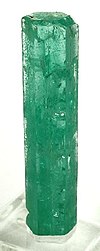
It is home of one of the largest emerald mines in the world.
Climate
Quípama has a tropical rainforest climate (Af) with heavy to very heavy rainfall year-round.
| Climate data for Quípama (Furatena Airport), elevation 1,250 m (4,100 ft), (1981–2010) | |||||||||||||
|---|---|---|---|---|---|---|---|---|---|---|---|---|---|
| Month | Jan | Feb | Mar | Apr | May | Jun | Jul | Aug | Sep | Oct | Nov | Dec | Year |
| Mean daily maximum °C (°F) | 27.0 (80.6) | 27.0 (80.6) | 27.2 (81.0) | 26.9 (80.4) | 26.9 (80.4) | 27.3 (81.1) | 27.9 (82.2) | 28.1 (82.6) | 27.5 (81.5) | 27.0 (80.6) | 26.8 (80.2) | 26.8 (80.2) | 27.3 (81.1) |
| Daily mean °C (°F) | 21.8 (71.2) | 21.8 (71.2) | 21.7 (71.1) | 21.6 (70.9) | 21.7 (71.1) | 21.7 (71.1) | 21.8 (71.2) | 22.1 (71.8) | 21.9 (71.4) | 21.7 (71.1) | 21.5 (70.7) | 21.7 (71.1) | 21.8 (71.2) |
| Mean daily minimum °C (°F) | 17.7 (63.9) | 17.7 (63.9) | 17.8 (64.0) | 17.6 (63.7) | 17.8 (64.0) | 17.8 (64.0) | 17.6 (63.7) | 17.6 (63.7) | 17.6 (63.7) | 17.8 (64.0) | 17.9 (64.2) | 17.9 (64.2) | 17.7 (63.9) |
| Average precipitation mm (inches) | 129.0 (5.08) | 208.4 (8.20) | 314.8 (12.39) | 365.8 (14.40) | 338.3 (13.32) | 239.6 (9.43) | 198.2 (7.80) | 191.8 (7.55) | 274.9 (10.82) | 391.2 (15.40) | 283.1 (11.15) | 179.1 (7.05) | 3,008 (118.4) |
| Average precipitation days (≥ 1.0 mm) | 17 | 17 | 22 | 23 | 25 | 21 | 19 | 18 | 22 | 24 | 22 | 19 | 238 |
| Average relative humidity (%) | 84 | 85 | 86 | 87 | 87 | 85 | 83 | 82 | 84 | 85 | 86 | 86 | 85 |
| Source: Instituto de Hidrologia Meteorologia y Estudios Ambientales[1] | |||||||||||||
See also
 Colombia portal
 Geology portal


- Las Pavas
- Muzo, Chivor, Somondoco
References
- ^ "Promedios Climatológicos 1981–2010" (in Spanish). Instituto de Hidrologia Meteorologia y Estudios Ambientales. Archived from the original on 15 August 2016. Retrieved 3 June 2024.
External links
Wikimedia Commons has media related to Quípama.
- v
- t
- e
Provinces and Municipalities in Boyacá Department 

See also: List of municipalities in Boyacá
| ||
|---|---|---|
| Gold |
|          |
| Silver | ||
| Platinum | ||
| Nickel |
| |
| Coltan | ||
| Emeralds | ||
| Coal | ||
| Salt | ||
| Sources |
| |
 Category • Images Category • Images  | ||
Colombian emeralds | |||||
|---|---|---|---|---|---|
| Geology |
|  | |||
| History |
| ||||
| Main mining areas |
| ||||
| Individual mines | |||||
| Individual emeralds (ct) |
| ||||
| Related articles | |||||
| |||||
5°31′N 74°11′W / 5.517°N 74.183°W / 5.517; -74.183
 | This Boyacá Department location article is a stub. You can help Wikipedia by expanding it. |
- v
- t
- e


