Rawley Springs, Virginia
Unincorporated community in Virginia, United States
38°30′19″N 79°3′23″W / 38.50528°N 79.05639°W / 38.50528; -79.05639 United States
Rawley Springs is an unincorporated community located in Rockingham County, in the U.S. state of Virginia.
Geography
It is located nine miles west of Harrisonburg, north of Clover Hill, along U.S. Route 33, near the George Washington National Forest.[1][2] It lies on the Dry River and is situated on the southern slope of the North Mountain.[1]
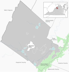

Rawley Springs
class=notpageimage|
Location of Rawley Springs within the Rockingham CountyReferences
- ^ a b Moorman, John Jennings (1859). The Virginia springs, and springs of the South and West. J.B. Lippincott & co. p. 298. Retrieved January 26, 2011.
- ^ Google Maps (Map). Google.
Wikimedia Commons has media related to Rawley Springs, Virginia.
- v
- t
- e
Municipalities and communities of Rockingham County, Virginia, United States
County seat: Harrisonburg
- Bridgewater
- Broadway
- Dayton
- Elkton
- Grottoes‡
- Mount Crawford
- Timberville

communities
- Bergton
- Berrytown
- Briery Branch
- Clover Hill
- Cootes Store
- Criders
- Cross Keys
- Dale Enterprise
- Edom
- Fulks Run
- Hinton
- Inglewood
- Lacey Spring
- Lilly
- Mauzy
- Mayland
- Mechanicsville
- Montezuma
- Mount Clinton
- New Erection
- Ottobine
- Penn Laird
- Pleasant Valley
- Rawley Springs
- Stemphleytown
- Tenth Legion
- Turleytown
- Yankeetown
‡This populated place also has portions in an adjacent county or counties
- Virginia portal
- United States portal
 | This Rockingham County, Virginia state location article is a stub. You can help Wikipedia by expanding it. |
- v
- t
- e


