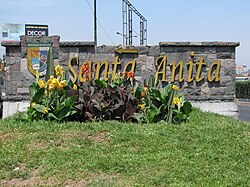
Santa Anita District
District in Lima, Peru
Saint Anita District Distrito de Santa Anita (Spanish) | |
|---|---|
District | |
 | |
 Flag  Coat of arms | |
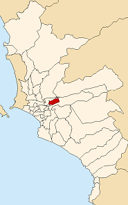 Location of Santa Anita in the Lima province | |
| Country |  Peru Peru |
| Region | Lima |
| Province | Lima |
| Founded | October 25, 1989 |
| Capital | Santa Anita |
| Subdivisions | 1 populated center |
| Government | |
| • Mayor | Olimpio Alegría (2023-2026) |
| Area | |
| • Total | 10.69 km2 (4.13 sq mi) |
| Elevation | 195 m (640 ft) |
| Population (2023)[1] | |
| • Total | 232,739 |
| Time zone | UTC-5 (PET) |
| UBIGEO | 150137 |
| Website | munisantanita.gob.pe |
Santa Anita is a district of the Lima Province in Peru. It is part of city of Lima. Officially established as a district on October 25, 1989, from parts of Ate and El Agustino separated by the Rio Surco, a ditch which went all the way to Santiago de Surco.
The current mayor (alcalde) of Santa Anita is Olimpio Alegría Calderón. The district's postal code is 43. The core sections of Santa Anita are: Santa Anita proper, originally a section of Ate; and Los Ficus and Universal, originally sections of El Agustino. Industrial areas to the east of Santa Anita and Universal mark the boundary with Ate.
Geography
The district has a total land area of 10.69 km2. Its administrative center is located 195 meters above sea level.
Boundaries
- North: El Agustino
- East: Ate
- South: Ate
- West: El Agustino
Demographics
According to a 2002 estimate by the INEI, the district has 154,359 inhabitants and a population density of 14,439.6 inhabitants/km2. In 1999, there were 27,908 households in the district.
See also
References
- ^ "Estadística Poblacional - Ministerio de Salud del Perú".
External links
Wikimedia Commons has media related to Santa Anita District.
- (in Spanish) Municipal website
12°02′35″S 76°57′30″W / 12.04306°S 76.95833°W / -12.04306; -76.95833
 | This Lima Province geography article is a stub. You can help Wikipedia by expanding it. |
- v
- t
- e


