Sonnenberg
You can help expand this article with text translated from the corresponding article in German. (December 2009) Click [show] for important translation instructions.
- View a machine-translated version of the German article.
- Machine translation, like DeepL or Google Translate, is a useful starting point for translations, but translators must revise errors as necessary and confirm that the translation is accurate, rather than simply copy-pasting machine-translated text into the English Wikipedia.
- Consider adding a topic to this template: there are already 9,155 articles in the main category, and specifying
|topic=will aid in categorization. - Do not translate text that appears unreliable or low-quality. If possible, verify the text with references provided in the foreign-language article.
- You must provide copyright attribution in the edit summary accompanying your translation by providing an interlanguage link to the source of your translation. A model attribution edit summary is
Content in this edit is translated from the existing German Wikipedia article at [[:de:Sonnenberg (Brandenburg)]]; see its history for attribution. - You may also add the template
{{Translated|de|Sonnenberg (Brandenburg)}}to the talk page. - For more guidance, see Wikipedia:Translation.
Municipality in Brandenburg, Germany
Sonnenberg | |
|---|---|
Municipality | |
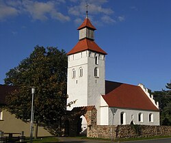 Church of Sonnenberg | |
Location of Sonnenberg within Oberhavel district  | |
| Area | |
| • Total | 50.30 km2 (19.42 sq mi) |
| Elevation | 64 m (210 ft) |
| Population (2022-12-31)[2] | |
| • Total | 838 |
| • Density | 17/km2 (43/sq mi) |
| Time zone | UTC+01:00 (CET) |
| • Summer (DST) | UTC+02:00 (CEST) |
| Postal codes | 16775 |
| Dialling codes | 033082 |
| Vehicle registration | OHV |
| Website | Gemeinde Sonnenberg |
Sonnenberg is a municipality in the Oberhavel district, in Brandenburg, Germany.
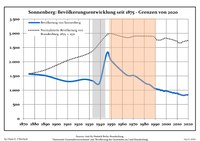
Demography
|
|
|
References
- ^ Landkreis Oberhavel Wahl der Bürgermeisterin / des Bürgermeisters, accessed 2 July 2021.
- ^ "Bevölkerungsentwicklung und Bevölkerungsstandim Land Brandenburg Dezember 2022" (PDF). Amt für Statistik Berlin-Brandenburg (in German). June 2023.
- ^ Detailed data sources are to be found in the Wikimedia Commons.Population Projection Brandenburg at Wikimedia Commons
- v
- t
- e
Towns and municipalities in Oberhavel
- Birkenwerder
- Fürstenberg/Havel
- Glienicke/Nordbahn
- Gransee
- Großwoltersdorf
- Hennigsdorf
- Hohen Neuendorf
- Kremmen
- Leegebruch
- Liebenwalde
- Löwenberger Land
- Mühlenbecker Land
- Oberkrämer
- Oranienburg
- Schönermark
- Sonnenberg
- Stechlin
- Velten
- Zehdenick

Authority control databases | |
|---|---|
| International |
|
| National |
|
 | This Brandenburg location article is a stub. You can help Wikipedia by expanding it. |
- v
- t
- e


