Spring Park, Croydon
Human settlement in England
- London
- Bexley and Bromley
- Croydon and Sutton
Spring Park is a small area in London, England. It is within the London Borough of Bromley and the London Borough of Croydon, straddling the traditional Kent-Surrey border along The Beck. Spring Park is located north of Addington, west of West Wickham and south of Monks Orchard and Shirley.[1]: 467
History
The area was historically known as Cold Harbour.[1]: 467 Settlement began in the area in the 1830s at the instigation of the MP John Temple Leader, who employed the agricultural innovator Hewitt Davis to turn what was barren heathland into productive farmland.[1]: 467 Large scale residential building began in the 1920s–1930s.[1]: 467 The Shrublands council estate was constructed after the Second World War on compulsorily purchased land from the golf course.[1]: 441
The area contains a small row of shops at the junction of Bridle Road and Broom Road. The Goat pub, which closed in 2017 following an attack on a local asylum seeker, re-opened in 2019 as The Apple Tree.[2]
Notable residents
- Joshua Buatsi - boxer, grew up on the Shrublands estate.[3]
Gallery
-
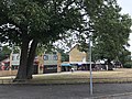 The Apple Tree pub, with Broom Road shops
 -
![All Saints Church on Bridle Road was built in 1955-6 by William Curtis Green and is a Grade II listed building.[4]](//upload.wikimedia.org/wikipedia/commons/thumb/c/cf/All_Saints_church%2C_Spring_Park%2C_Shirley%2C_Croydon_-_geograph.org.uk_-_34331.jpg/120px-All_Saints_church%2C_Spring_Park%2C_Shirley%2C_Croydon_-_geograph.org.uk_-_34331.jpg) All Saints Church on Bridle Road was built in 1955-6 by William Curtis Green and is a Grade II listed building.[4]
All Saints Church on Bridle Road was built in 1955-6 by William Curtis Green and is a Grade II listed building.[4] -
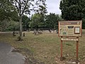
 Clearing in the woods that border the Shrublands estate
 -
 Millers Pond, originally part of Spring Park Farm

![All Saints Church on Bridle Road was built in 1955-6 by William Curtis Green and is a Grade II listed building.[4]](http://upload.wikimedia.org/wikipedia/commons/thumb/c/cf/All_Saints_church%2C_Spring_Park%2C_Shirley%2C_Croydon_-_geograph.org.uk_-_34331.jpg/120px-All_Saints_church%2C_Spring_Park%2C_Shirley%2C_Croydon_-_geograph.org.uk_-_34331.jpg)


References
- ^ a b c d e Willey, Russ (2007). London gazetteer. Edinburgh : Chambers. ISBN 978-0-550-10326-0. Retrieved 7 March 2024.
- ^ "The Goat pub in Shirley is reopening very soon under a new name". MyLondon. 16 September 2019. Retrieved 12 August 2020.
- ^ "Rio 2016: Croydon boxer Joshua Buatsi guaranteed at least a bronze medal". MyLondon. 15 August 2016. Retrieved 19 August 2020.
- ^ Historic England. "Church of All Saints (1376050)". National Heritage List for England. Retrieved 31 January 2020.
- v
- t
- e
- Anerley
- Aperfield
- Beckenham
- Berry's Green
- Bickley
- Biggin Hill
- Bromley
- Bromley Common
- Chelsfield
- Chislehurst
- Coney Hall
- Crystal Palace
- Cudham
- Downe
- Eden Park
- Elmers End (including Upper Elmers End)
- Elmstead
- Farnborough
- Foxbury
- Goddington
- Green Street Green
- Hayes
- Hazelwood
- Hockenden
- Horns Green
- Keston
- Kevington
- Leaves Green
- Locksbottom
- Longlands
- Luxted
- Mottingham
- New Beckenham
- Orpington (including: Broom Hill, Crofton, Derry Downs and Ramsden)
- Park Langley
- Penge
- Petts Wood
- Plaistow
- Poverest
- Pratt's Bottom
- Ruxley
- St Mary Cray
- St Paul's Cray
- Shortlands
- Single Street
- Southborough
- South Street
- Sundridge
- Sydenham
- Upper Norwood
- West Wickham
- Widmore


- Betts Park
- Chislehurst Common
- Crofton Wood
- Croydon Road Recreation Ground
- Crystal Palace Park
- Cuckoo Wood
- Downe Bank
- Elmstead Wood
- Hayes Common
- High Elms Country Park
- Jubilee Country Park
- Kelsey Park
- Keston Common
- Norman Park
- Ruxley Gravel Pits
- Saltbox Hill
- Scadbury Park
- Sundridge Park
- The Warren
- West Kent Golf Course nature reserve
- Beckenham
- Bromley and Chislehurst
- Lewisham West and Penge
- Orpington
tram stops

 Anerley
 Avenue Road
- Beckenham Road
- Beckenham Junction
- Bickley
- Birkbeck
- Bromley North
- Bromley South
- Chelsfield
- Chislehurst
- Clock House
- Crystal Palace
- Eden Park
- Elmers End
- Elmstead Woods
- Hayes
- Kent House
- Knockholt
- Lower Sydenham
- New Beckenham
- Orpington
- Penge East
- Penge West
- Petts Wood
- Ravensbourne
- St Mary Cray
- Shortlands
- Sundridge Park
- West Wickham


 Category
 Commons


 | This London location article is a stub. You can help Wikipedia by expanding it. |
- v
- t
- e


