Umm er Rus
Ancient ruin in the Judean mountains
Horvat Bet Bad (appears In the P.E.F. maps as Kh. Umm er-Rus) is located east of the Ela valley, 2.5 km south east from Khirbet Beit Natif and about 3 km north east of Adullam. The site has the remains of a Jewish village from the Second Temple Period, a monastery from the 12th century and a two-story Ottoman structure.31°41′20.9″N 35°01′16.76″E / 31.689139°N 35.0213222°E / 31.689139; 35.0213222
In Arabic it is know as Umm er Rus (Arabic: امّ الرؤوس), alternate spelling Um Ra'us (literal meaning: "mother of the summits"), is a Roman-Byzantine era ruin that sits high on a spur in the Judean mountains, overlooking the Elah valley. The site was formerly known in Arabic as Umm er Rûs esh-Shamālīya ("the northern Umm er Rus"), to distinguish it from another site by the same name, lying on an adjacent hill to its south. The site takes its Arabic name from the prospect that it affords, having the broad connotation of "the place with the hill-top."[1] Its older Hebrew appellation is no longer known. The ruin is located a little less than 1 mile northeast of Aviezer.
History
The village, during Israel's Second Temple Period, was located in the district known then as Idumaea, named presumably for its inhabitants who were descended from the progeny of Esau, their ancestor, and who came to embrace the Jewish religion in the days of John Hyrcanus.[2] By the mid-1st-century CE, the inhabitants of this district sought independence from the yoke of the Roman Imperial army. Nothing is known of the village's demise, although it can be assumed that, owing to its proximity to Bethletephon (Beit Nettif),[3] the village fell along with Bethletephon during the initial Roman onslaught of that region by Vespasian, who sent against them the Tenth and Fifteenth legions, in an effort to quell the insurrection.
He (Vespasian) came to the toparchy of Bethletephon. He then destroyed that place, and the neighboring places, by fire, and fortified, at proper places, the strong holds all about Idumaea; and when he had seized upon two villages, which were in the very midst of Idumaea, Betaris and Caphartobas, he slew above ten thousand of the people, and carried into captivity above a thousand, and drove away the rest of the multitude, and placed no small part of his own forces in them, who overran and laid waste the whole mountainous country.[4]
The site may have been resettled and destroyed a second time during the outbreak of hostilities under Hadrian, a time of great upheaval and unrest in Judea, as described by Cassius Dio's Roman History.
Fifty of their most important outposts and nine hundred and eighty-five of their most famous villages were razed to the ground. Five hundred and eighty thousand men were slain in the various raids and battles, and the number of those that perished by famine, disease and fire was past finding out. Thus nearly the whole of Judaea was made desolate .[5]
In 1883 the PEF's Survey of Western Palestine described the "Umm ar Rus": "Foundations, walls, and cisterns. They appear to be Crusading work."[6]
Description

The current ruin sits at a mean elevation of 443 metres (1,453 ft) above sea-level, sprawling over an area of about 15 dunams (3.7 acres). Potsherds are strewn across its grounds, with several razed houses, one of which showing several courses of large, hewn ashlars, measuring upwards of 2 metres.[7] A wall which once served as the village's defences is broken down. A rock-cut tomb lay on the village's western-most quarter. A massive stone-carved well-covering is seen partially upturned over the mouth of the village well, in its eastern quarters.
Umm er Rus (southern site)


The southern site (31°41′00″N 35°01′16″E / 31.683454°N 35.021127°E / 31.683454; 35.021127 (Horbat Beit Bad)), also known by the name Umm er Rus, is distanced 2.5 kilometers southeast of Beit Nattif and sits on the fringes of Moshav Aviezer, at an elevation of 454 metres (1,490 ft) above sea level. The site was inhabited by Jews during the early and late Roman era period, based on the discovery of a ritual bath in situ. To distinguish it from its sister site to the north, the southern site has been given the additional name Ḥorbat Beit Bad ("the ruin of the olive press").[8] A Byzantine Church is known to have existed at the site in late antiquity,[9][10] where was discovered in 1898 a dedicatory inscription to St. John in both Greek and Syriac.[11] A crypt belonging to the church, with arcosolia in the walls, was resurveyed in 2014 by inspectors from the Antiquities Theft Prevention Unit following damage to the site caused by antiquities looters. According to archaeologist Eitan Klein, the cave walls were coated with gray plaster of the type characteristic of the Second Temple period, suggesting that this was a ritual bath from that period that was later converted into a burial cave.[12]
Wine presses are noticeable on the site, cisterns, underground storage facilities, as well as a rock-cut, plastered ritual bath (mikveh), hewn in a trapezoidal manner and measuring approximately 3.1–3.6 x 3.6–4.1 m (10.1–11.8 x 11.8–13.4 ft.), connected to a large underground water reservoir (approximately 9 x 8 m).[13][14] The potsherds and fragments of a spindle-like bottle attest to a Jewish settlement in the 2nd century BCE to the 2nd century CE.[14]
The site has a history of being plagued by antiquities robbers.[15]
Further reading
- Vincent, H. (1898). "Une église à Oumm er Rous". Revue Biblique (in French). 7 (4). Leuven: Peeters Publishers: 611–615. JSTOR 44100398.
- Vincent, H. (1898). "Encore l'église à Oumm er Rous". Revue Biblique (in French). 8. Leuven: Peeters Publishers: 452–457.
Gallery
-
 Upturned stone covering of well
 -
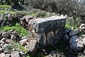
 Stone well-covering
 -
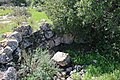
 Walled structure of old house
 -
 House ruins in Umm er Rus
 -
 Stone blocks used in wall of house
 -
 Hewn stone used as wall of house
 -
 General view of razed house
 -
 Old structure at the Umm er Rus ruin
 -
 Stones of razed house
 -
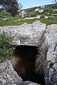 Cave-like pit (jīʻ) accessible from the side, at Umm er Rus (northern site)
 -
 Impression carved in rock, possibly a launderer's pool
 -
 Ancient burial tomb
 -
 Rock-cut tomb
 -
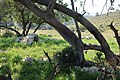 Dale near the Umm er Rus ruin
 -
 Road leading to ancient ruin (Khallat ez-Zeituna)


References
- ^ Palmer (1881), p. 330
- ^ Gottheil (1901), pp. 40–41
- ^ Robinson (1881), p. 342 (note 1), who places the village Um er Rûs to the immediate southeast of Beit Nettif. From Beit Nettif, Robinson describes the general area, saying (p. 341): "The whole tract is full of villages and deserted sites and ruins."
- ^ Josephus, The Jewish War (4.8.1. 4.440)
- ^ Cassius Dio, Roman History, published in Vol. VIII of the Loeb Classical Library edition, 1925, Epitome of Book LXIX:14 (pp. 449–451)
- ^ Conder and Kitchener, 1883, SWP III, p.161
- ^ The Archaeological Survey of Israel, Israel Antiquities Authority, Umm er-Rus (northern site), Site no. 205
- ^ The Archaeological Survey of Israel, Israel Antiquities Authority, Umm er-Rus (southern site), Site no. 206
- ^ Macalister (1899), pp. 200–204.
- ^ Milik (1953), pp. 526-539
- ^ Klein (2018), Summary
- ^ Klein (2018), Summary
- ^ Zissu (2007), p. 1
- ^ a b Umm er-Rus, Amud-anan
- ^ Zissu (2007), p. 1
Bibliography
- Conder, C.R.; Kitchener, H.H. (1883). The Survey of Western Palestine: Memoirs of the Topography, Orography, Hydrography, and Archaeology. Vol. 3. London: Committee of the Palestine Exploration Fund.
- Gottheil, R.; Seligsohn, M. (1901). "Edom, Idumaea". The Jewish Encyclopedia. Vol. 3. Funk and Wagnalls. LCCN 16014703. Archived from the original on 2007-09-21. Retrieved 15 February 2021.
- Klein, Eitan; Goldenberg, Gidon (2018). "Kh. Umm er-Rus (Horbat Bet Bad) Reconsidered: New Insights from an Underground Archaeological Survey". Revue biblique. 125 (1). Jerusalem: École Biblique: 90–119. doi:10.2143/RBI.125.1.3284860. ISSN 2466-8583.
- Macalister, R. A. S. (1899). "A Byzantine Church at Umm er Rûs". Palestine Exploration Quarterly. 31 (3): 200–204. doi:10.1179/peq.1899.31.3.200.
- Milik, J.-T. [in French] (1953). "Une inscription et une lettre en araméen christo-palestinien". Revue Biblique (in French). 60 (4). Leuven: Peeters Publishers: 526–539. JSTOR 44091668.
- Palmer, E.H. (1881). The Survey of Western Palestine: Arabic and English Name Lists Collected During the Survey by Lieutenants Conder and Kitchener, R. E. Transliterated and Explained by E.H. Palmer. Committee of the Palestine Exploration Fund.
- Robinson, E.; Smith, E. (1841). Biblical Researches in Palestine, Mount Sinai and Arabia Petraea: A Journal of Travels in the year 1838. Vol. 2. Boston: Crocker & Brewster.
- Zissu, B. [in Hebrew]; Ganor, Amir (2007). "Khirbat Umm er-Rûs". Hadashot Arkheologiyot: Excavations and Surveys in Israel. 119. Jerusalem: Israel Antiquities Authority. JSTOR 26584460.
External links
- Survey of Western Palestine, 1880 Map, Map 17: IAA, Wikimedia commons, showing both the northern and southern sites of Umm er Rûs (appx. East longitude, 35.01; North latitude, 31.41)
- "Khirbat Umm er-Rûs", Hadashot Arkheologiyot, Excavations and Surveys in Israel, Boaz Zissu and Amir Ganor


