Upminster Tithe Barn Museum of Nostalgia
Museum in Upminster, London
 | |
 | |
| Established | 1976; 48 years ago (1976) |
|---|---|
| Location | Hall Lane, Upminster |
| Curator | Ian Whaley |
| Public transit access |   |
| Website | upminstertithebarn.co.uk |
The Upminster Tithe Barn Museum of Nostalgia is a small museum located in Upminster in the London Borough of Havering, London, England. It is located at OS grid reference TQ564877.
It is owned by Havering London Borough Council and run in partnership with the Hornchurch and District Historical Society. The museum holds around 14,500 artifacts of domestic and agricultural use.
As of 2024[update], the museum is closed while a significant programme of works is undertaken on the barn structure and roof, funded by a grant provided by the National Highways Company.
The museum opened in 1976. The thatched barn in which the museum is located was built in 1450 by the nearby priory (dependent on Waltham Abbey). Although commonly known as the Tithe Barn, the building was never used for the collection of tithes and a grange barn might be a more accurate designation (Upminster's real tithe barn adjoined the rectory in what is now Gridiron Place). Upminster station is the nearest National Rail and London Underground station. The Upminster Tithe Barn Museum is served by London Buses route 248.
Gallery
-
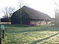 North face
 -
 West face
 -
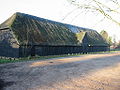 South face, main entrance


See also
- Tithe barn
References
External links
- Official website
- London 21 — Listing
- v
- t
- e
- Ardleigh Green
- Beam Park
- Chase Cross
- Coldharbour
- Collier Row
- Cranham
- Elm Park
- Emerson Park
- Frog Island
- Gallows Corner
- Gidea Park
- Hacton
- Harold Hill
- Harold Park
- Harold Wood
- Havering-atte-Bower
- Heath Park
- Hornchurch
- Hornchurch Marshes
- Noak Hill
- North Ockendon
- Rainham
- Rise Park
- Romford
- Rush Green
- South Hornchurch
- Upminster
- Upminster Bridge
- Wennington


- The Brewery
- The Liberty
- The Mercury
- Romford Market
- Bedfords Park
- Cranham Brickfields
- Cranham Marsh
- Dagnam Park
- Hainault Forest
- Harrow Lodge Park
- Havering Country Park
- Haynes Park
- Hornchurch Country Park
- Hylands Park
- Ingrebourne Marshes
- Ingrebourne Valley
- Lodge Farm Park
- Pages Wood
- Pyrgo Park
- Rainham Marshes Nature Reserve
- Raphael Park
- St Andrew's Park
- Tylers Common
- Weald Brook
- Wildspace Conservation Park
- Dagenham and Rainham (part)
- Hornchurch and Upminster
- Romford

 Category
 Commons

51°34′00″N 0°15′25″E / 51.5668°N 0.2569°E / 51.5668; 0.2569
 | This article about a London building or structure is a stub. You can help Wikipedia by expanding it. |
- v
- t
- e
  | This article relating to a museum in the United Kingdom is a stub. You can help Wikipedia by expanding it. |
- v
- t
- e


