Waldburg-Wurzach
County (Principality) of Waldburg-Wurzach Grafschaft (Fürstentum) Waldburg-Wurzach | |||||||||
|---|---|---|---|---|---|---|---|---|---|
| 1674–1806 | |||||||||
 Coat of arms | |||||||||
| Status | State of the Holy Roman Empire | ||||||||
| Capital | Wurzach | ||||||||
| Common languages | Alemannic German | ||||||||
| Government | Principality | ||||||||
| Historical era | Middle Ages | ||||||||
• Partitioned from Waldburg-Zeil | 1674 | ||||||||
• Raised to principality | 1803 | ||||||||
| 1806 | |||||||||
| |||||||||


Waldburg-Wurzach was a County and later Principality within Holy Roman Empire, ruled by the House of Waldburg, located on the southeastern border of Baden-Württemberg, Germany, located around Wurzach (located about 15 km (9 mi) west of Bad Waldsee). Waldburg-Wurzach was a partition of Waldburg-Zeil. Waldburg-Wurzach was a county prior to 1803, when it was raised to a principality shortly before being mediatised to Württemberg in 1806.
Rulers of Waldburg-Wurzach
Counts of Waldburg-Wurzach (1674–1803)
- Sebastian Wunibald (1674–1700)
- Ernest James (1700–34)
- Francis Ernest (1734–81)
- Eberhard I (1781–1803)
Prince of Waldburg-Wurzach (1803–06)
- Eberhard I (1803–06)
- v
- t
- e
 Swabian Circle (1500–1806) of the Holy Roman Empire
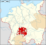
- Altshausen
- Baar
- Bondorf
- Buchau
- Eberstein
- Eglingen
- Eglofs
- Fugger
- Jakob
- Johann
- Markus
- Gundelfingen
- Gutenstein
- Hausen
- Heiligenberg
- Helfenstein
- Hohenems
- Hohengeroldseck
- Hohenzollern-Sigmaringen
- Justingen
- Kinzigerthal
- Königsegg and Aulendorf
- Lustenau
- Meßkirch
- Mindelheim / Schwabegg
- Oberdischingen
- Öttingen
- Baldern
- Öttingen
- Wallerstein
- Rechberg
- Rothenfels and Stauffen
- Stühlingen and Hohenhöwen
- Tettnang / Langenargen
- Thannhausen
- Wiesensteig
Circles est. 1500: Bavarian, Swabian, Upper Rhenish, Lower Rhenish–Westphalian, Franconian, (Lower) Saxon
Circles est. 1512: Austrian, Burgundian, Upper Saxon, Electoral Rhenish · Unencircled territories
Circles est. 1512: Austrian, Burgundian, Upper Saxon, Electoral Rhenish · Unencircled territories
47°55′N 9°46′E / 47.917°N 9.767°E / 47.917; 9.767
 | This Baden-Württemberg location article is a stub. You can help Wikipedia by expanding it. |
- v
- t
- e
  | This German history article is a stub. You can help Wikipedia by expanding it. |
- v
- t
- e


