Wan Bhachran
Town Committee in Pakistan
Wan Bhachran واں بهچراں | |
|---|---|
Town Committee | |
 Wan Bhachran Railway Station (made in the British Raj) | |
| 32°24′57″N 71°41′38″E / 32.4159°N 71.6940°E / 32.4159; 71.6940 | |
| Country | Pakistan |
| District | Mianwali District |
| Government | |
| • Chairman | Malik Sajjad Ahmad Khan Bhacher Bandial |
| Population | |
| • Town Committee | 95,000 |
| • Urban | 65,000 |
| Time zone | UTC+5 |
Wan Bhachran (Urdu: واں بهچراں), is a town committee of Mianwali District in Punjab province of Pakistan.[1] It is part of Mianwali Tehsil. The word 'Wan' means 'a well' in the Punjabi language. It refers to the well that is situated in the town made by Sher Shah Suri. Whereas 'Bhachars' refers to Qutabshahi khoker Awan, Bhachar clan is prevalent in this part of the region.
In the British era, Wan Bhachran was an independent state consisting of several surrounding areas, including Wan Bhachran City, Pakka Ghanjera, Nangni, Chak Maris, Nari, Sheikhali, Chandni, Phati, Chor Wala, Tibi, Shadia, Pakka Sandan Wala, Muhammad Shah, Bhattian Wala, Jhabar, Bhouki, Kabari, Main Din Wala, Natalanwala, Khichi, Asran Wala, Anwar Chowk, Bala Sharif, Vichven, and several Chakouk etc.
These areas come under the jurisdiction of Wan Bhachran police station
The people of Wan Bhachran and surrounding areas speak Saraiki and belong to different castes of the Muslim Jutt,Rajpot & Arab tribes.
Wheat, rice, sugarcane, millet, corn, millet, cotton, peanuts, canola orchards, canola, gram, guava, peanuts and sunflower are the popular crops here.
Images
Pictures of Wan Bhachran
-
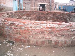
 Entrance to the stairs of well made by Sher Shah Suri (presumably used for horses and elephants)
 -
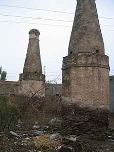
 The vertical opening of the well made by Sher Shah Suri (Brick work is now getting damaged.)
 -
 View of Wan Bhachran looking North (In the background is Salt Range, specifically Sakesar.)
 -
 View looking West (Here greenry is primarily due to the irrigation canal passing on the outskirts.)


Refe
- ^ "Mianwali District LGs, SOE | Local Government and Community Development". lgcd.punjab.gov.pk. Retrieved 2020-11-07.
- v
- t
- e
Administrative divisions of Mianwali District
- Mianwali
- Isakhel
- Mianwali
- Piplan
- Abbakhel
- Alluwali
- Ban Hafiz Jee
- Chakrala
- Chapri
- Chhidru
- Dabb Balouchan
- Daud Khel(Rural)
- Daood Khel (Town)
- Dher Umid Ali Shah
- Doaba
- Gujrat
- Gulmiri
- Hafiz Wala
- Hernoli(Rural)
- Harrnauli(Urban)
- Isakhel
- Kalabagh
- Kallur
- Kamar Mushani
- Kamar Mushani Pakka
- Khaglan Wala
- Khanqah Sirajia
- Kot Chandna
- Kundian-I
- Kundian-Ii
- Kundian Rural
- Mari
- Mianwali City -I
- Mianwali City -Ii
- Mianwali City -Iii
- Mianwali City -Iv
- Mochh
- Musakhel
- Muzafarpur Janubi
- Muzafarpur Shumali
- Namal
- Paikhel
- Piplan
- Qureshian
- Rokhri
- Shadia
- Shahbaz Khel
- Sultan Khel
- Swans
- Tabisar
- Tanikhel
- Thamewali
- Tibba Mehrban Shah
- Tola Bhangi Khel
- Trag
- Vanjari
- Vichvin Bala
- Wan Bhachran
- Watta Khel
- Yaru Khel


