Contea di Marion (Kansas)

Questa voce sull'argomento contee del Kansas è solo un abbozzo.
Contribuisci a migliorarla secondo le convenzioni di Wikipedia.
| Contea di Marion contea | |
|---|---|
| Localizzazione | |
| Stato |  Stati Uniti Stati Uniti |
| Stato federato |  Kansas Kansas |
| Amministrazione | |
| Capoluogo | Marion |
| Data di istituzione | 1855 |
| Territorio | |
| Coordinate del capoluogo | 38°24′N 97°09′W38°24′N, 97°09′W (Contea di Marion) |
| Superficie | 2 470 km² |
| Abitanti | 12 112 (2016) |
| Densità | 4,9 ab./km² |
| Altre informazioni | |
| Fuso orario | UTC-6 |
| Cartografia | |
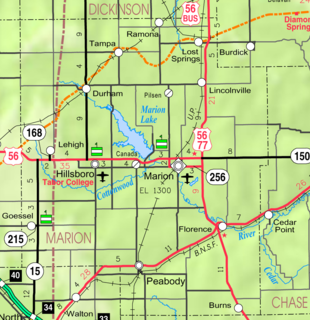
  Marion | |
 | |
| Sito istituzionale | |
| Modifica dati su Wikidata · Manuale | |
La contea di Marion in inglese Marion County è una contea dello Stato del Kansas, negli Stati Uniti. La popolazione al censimento del 2016 era di 12.112 abitanti. Il capoluogo di contea è Marion
Geografia fisica
Secondo lo United States Census Bureau, la contea ha una superficie di 2471 km² di cui 2445 km² è terra (98,95%) e 24 km² (1,05%) acque interne.
Contee confinanti
- Dickinson County (north)
- Morris County (northeast)
- Chase County (east)
- Butler County (southeast)
- Harvey County (southwest)
- McPherson County (west)
- Saline County (northwest)
Geografia antropica
Città
- Burns (precedentemente noto come St. Francis)
- Durham (precedentemente noto come Durham Park)
- Florence
- Goessel (precedentemente noto come Gnadenfeld)
- Hillsboro precedentemente noto come Hill City)
- Lehigh
- Lincolnville
- Lost Springs
- Marion (precedentemente noto come Marion Centre)
- Peabody (precedentemente noto come Coneburg)
- Ramona
- Tampa
Area non incorporata
- Antelope
- Aulne
- Canada
- Eastshore
- Marion County Lake
- Pilsen
Ghost towns
La contea di Marion conteneva comunità antiche che sono state abbandonate da tempo.
- Stazioni ferroviarie / Stazioni / Cattle Pens
- Hampson, station, approximately 5 miles south of Florence.[1]
- Horners (Honner), station and cattle pens, approximately 3 miles northeast of Peabody.[2]
- Jacobs, TBD, northwest of Lost Springs.
- Oursler, station and tiny community.
- Quarry, station and limestone rock quarry, approximately 5.5 miles north of Marion.
- Wagner, TBD, southwest of Florence.
- Waldeck, station, cattle pens, and tiny community.
- Morning Star
- Strassburg
- Youngtown, northeast of Marion
- Alexanderfeld
- Ebenfeld
- Friedenstal (Alvin)
- Gnadenau (Grace Meadow)
- Hoffnungsthal (Hope Valley)
- Schoenthal (Fair Valley)
- Steinbach
- Alexanderwohl Villaggi mennoniti[3]
- Blumenfeld (sul confine della contea di McPherson)
- Blumenort (sul confine della contea di McPherson)
- Emmathal
- Gnadenfeld
- Gnadenthal
- Gruenfeld (Green Field) (abbandonato poi più tardi divenne Goessel)
- Hochfeld
- Springfield
Townships
| Township | FIPS | Population center | Population | Population density /km² (/sq mi) | Land area km² (sq mi) | Water area km² (sq mi) | Water % | Geographic coordinates |
|---|---|---|---|---|---|---|---|---|
| Blaine | 07125 | Tampa | 212 | 2 (6) | 93 (36) | 0 (0) | 0.33% | 38°33′30″N 97°10′46″W38°33′30″N, 97°10′46″W |
| Catlin | 11075 | Peabody | 180 | 2 (5) | 93 (36) | 0 (0) | 0.05% | 38°12′56″N 97°05′14″W38°12′56″N, 97°05′14″W |
| Centre | 11825 | * | 535 | 4 (11) | 128 (49) | 0 (0) | 0.26% | 38°20′36″N 96°59′39″W38°20′36″N, 96°59′39″W |
| Clark | 13500 | Pilsen | 149 | 2 (4) | 93 (36) | 0 (0) | 0.42% | 38°28′17″N 97°06′04″W38°28′17″N, 97°06′04″W |
| Clear Creek | 13750 | Lincolnville | 592 | 3 (8) | 196 (76) | 0 (0) | 0.06% | 38°28′01″N 96°57′35″W38°28′01″N, 96°57′35″W |
| Colfax | 14800 | Ramona | 218 | 2 (6) | 93 (36) | 0 (0) | 0.01% | 38°34′42″N 97°05′28″W38°34′42″N, 97°05′28″W |
| Doyle | 18550 | * | 75 | 1 (2) | 98 (38) | 0 (0) | 0.08% | 38°14′03″N 96°53′17″W38°14′03″N, 96°53′17″W |
| Durham Park | 19100 | Durham | 230 | 3 (7) | 90 (35) | 3 (1) | 2.70% | 38°29′09″N 97°12′46″W38°29′09″N, 97°12′46″W |
| East Branch | 19325 | n/a | 188 | 2 (5) | 92 (35) | 0 (0) | 0% | 38°13′33″N 97°11′53″W38°13′33″N, 97°11′53″W |
| Fairplay | 22350 | * | 121 | 1 (3) | 116 (45) | 0 (0) | 0.04% | 38°13′44″N 96°59′23″W38°13′44″N, 96°59′23″W |
| Gale | 25075 | Eastshore | 220 | 3 (8) | 67 (26) | 21 (8) | 23.70% | 38°23′15″N 97°05′21″W38°23′15″N, 97°05′21″W |
| Grant | 27775 | n/a | 128 | 1 (2) | 174 (67) | 0 (0) | 0.08% | 38°22′13″N 96°53′03″W38°22′13″N, 96°53′03″W |
| Lehigh | 39250 | Lehigh | 370 | 4 (10) | 93 (36) | 0 (0) | 0% | 38°23′03″N 97°18′27″W38°23′03″N, 97°18′27″W |
| Liberty | 40225 | * | 327 | 4 (9) | 92 (35) | 0 (0) | 0% | 38°18′13″N 97°12′37″W38°18′13″N, 97°12′37″W |
| Logan | 41950 | n/a | 127 | 1 (4) | 94 (36) | 0 (0) | 0.07% | 38°32′38″N 97°19′34″W38°32′38″N, 97°19′34″W |
| Lost Springs | 42850 | Lost Springs | 201 | 2 (6) | 93 (36) | 0 (0) | 0.01% | 38°34′14″N 96°58′23″W38°34′14″N, 96°58′23″W |
| Menno | 45800 | n/a | 317 | 3 (9) | 93 (36) | 0 (0) | 0.12% | 38°18′50″N 97°18′34″W38°18′50″N, 97°18′34″W |
| Milton | 46900 | Burns | 348 | 4 (12) | 78 (30) | 0 (0) | 0.03% | 38°06′06″N 96°53′04″W38°06′06″N, 96°53′04″W |
| Moore | 48100 | n/a | 65 | 1 (2) | 93 (36) | 0 (0) | 0.03% | 38°29′27″N 97°19′39″W38°29′27″N, 97°19′39″W |
| Peabody | 55125 | Peabody | 1,544 | 16 (42) | 95 (37) | 0 (0) | 0.23% | 38°09′40″N 97°06′22″W38°09′40″N, 97°06′22″W |
| Risley | 60000 | * | 241 | 3 (7) | 89 (34) | 1 (0) | 1.36% | 38°23′56″N 97°11′48″W38°23′56″N, 97°11′48″W |
| Summit | 69100 | n/a | 82 | 1 (2) | 92 (36) | 0 (0) | 0.51% | 38°07′21″N 96°58′54″W38°07′21″N, 96°58′54″W |
| West Branch | 76775 | Goessel | 1,024 | 11 (29) | 92 (36) | 0 (0) | 0.01% | 38°13′30″N 97°19′35″W38°13′30″N, 97°19′35″W |
| Wilson | 79750 | Aulne | 232 | 2 (6) | 94 (36) | 0 (0) | 0% | 38°18′17″N 97°05′19″W38°18′17″N, 97°05′19″W |
Note
- ^ Blackmar, Frank Wilson, Kansas: A Cyclopedia of State History, Embracing Events, Institutions, Industries, Counties, Cities, Towns, Prominent Persons, Etc., Standard Publishing Company, 1912, p. 805.
- ^ Blackmar, Frank Wilson, Kansas: A Cyclopedia of State History, Embracing Events, Institutions, Industries, Counties, Cities, Towns, Prominent Persons, Etc., Standard Publishing Company, 1912, p. 872.
- ^ (EN) Mennonite Life, su Mennonite Life. URL consultato il 6 febbraio 2019.
Altri progetti
Altri progetti
- Wikimedia Commons
 Wikimedia Commons contiene immagini o altri file su contea di Marion
Collegamenti esterni
- (EN) Sito ufficiale, su MarionCoKS.net.

- (EN) Contea di Marion, su Geographic Names Information System, USGS.

V · D · M | |
|---|---|
| Contee | Allen · Anderson · Atchison · Barber · Barton · Bourbon · Brown · Butler · Chase · Chautauqua · Cherokee · Cheyenne · Clark · Clay · Cloud · Coffey · Comanche · Cowley · Crawford · Decatur · Dickinson · Doniphan · Douglas · Edwards · Elk · Ellis · Ellsworth · Finney · Ford · Franklin · Geary · Gove · Graham · Grant · Gray · Greeley · Greenwood · Hamilton · Harper · Harvey · Haskell · Hodgeman · Jackson · Jefferson · Jewell · Johnson · Kearny · Kingman · Kiowa · Labette · Lane · Leavenworth · Lincoln · Linn · Logan · Lyon · Marion · Marshall · McPherson · Meade · Miami · Mitchell · Montgomery · Morris · Morton · Nemaha · Neosho · Ness · Norton · Osage · Osborne · Ottawa · Pawnee · Phillips · Pottawatomie · Pratt · Rawlins · Reno · Republic · Rice · Riley · Rooks · Rush · Russell · Saline · Scott · Sedgwick · Seward · Shawnee · Sheridan · Sherman · Smith · Stafford · Stanton · Stevens · Sumner · Thomas · Trego · Wabaunsee · Wallace · Washington · Wichita · Wilson · Woodson · Wyandotte |
| Regioni | Altopiano d'Ozark · Area metropolitana di Kansas City · Cherokee Strip · East Central · Flint Hills · High Plains · Red Hills · Smoky Hills · Southeast |
| Aree metropolitane | Capitale: Topeka Maggiori città: Derby · Dodge City · Emporia · Garden City · Hays · Hutchinson · Kansas City · Lawrence · Leavenworth · Leawood · Lenexa · Liberal · Manhattan · Olathe · Overland Park · Prairie Village · Salina · Shawnee · Topeka · Wichita |
| Controllo di autorità | VIAF (EN) 157114009 · LCCN (EN) n81039971 · J9U (EN, HE) 987007557314105171 |
|---|
 Portale Stati Uniti d'America: accedi alle voci di Wikipedia che parlano degli Stati Uniti d'America


