Hulcote and Salford
Civil parish in Engeland  | |||
|---|---|---|---|
  | |||
| Situering | |||
| Nederzettingen | Hulcote en Salford | ||
| Graafschap | Bedfordshire | ||
| Regio | East of England | ||
| District | Central Bedfordshire | ||
| Coördinaten | 52° 3′ NB, 0° 38′ WL | ||
| Algemeen | |||
| Oppervlakte | 7,8262 km² | ||
| Inwoners (2011) | 209 (27 inw./km²) | ||
| Foto's | |||
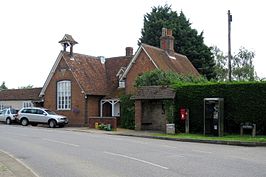 | |||
| Salford Village Hall | |||
| |||

Hulcote and Salford (ONS-code E04011960) is een civil parish in het bestuurlijke gebied Central Bedfordshire, in het Engelse graafschap Bedfordshire. Hulcote and Salford bestaat uit Hulcote en Salford.
Mediabestanden
Zie de categorie Hulcote and Salford van Wikimedia Commons voor mediabestanden over dit onderwerp.
Civil parishes in het ceremoniële graafschap Bedfordshire
Ampthill · Arlesey · Aspley Guise · Aspley Heath · Astwick · Barton-le-Clay · Battlesden · Biddenham · Biggleswade · Billington · Bletsoe · Blunham · Bolnhurst and Keysoe · Brickhill · Brogborough · Bromham · Caddington · Campton and Chicksands · Cardington · Carlton with Chellington · Central Bedfordshire · Chalgrave · Chalton · Clapham · Clifton · Clophill · Colmworth · Cople · Cranfield · Dean and Shelton · Dunstable · Dunton · Eastcotts · Eaton Bray · Edworth · Eggington · Elstow · Eversholt · Everton · Eyeworth · Felmersham · Flitton and Greenfield · Flitwick · Gravenhurst · Great Barford · Great Denham · Harlington · Harrold · Haynes · Heath and Reach · Henlow · Hockliffe · Houghton Conquest · Houghton Regis · Hulcote and Salford · Husborne Crawley · Hyde · Kempston · Kempston Rural · Kensworth · Knotting and Souldrop · Langford · Leighton-Linslade · Lidlington · Little Barford · Little Staughton · Marston Moretaine · Maulden · Melchbourne and Yielden · Meppershall · Millbrook · Milton Bryan · Milton Ernest · Moggerhanger · Northill · Oakley · Odell · Old Warden · Pavenham · Pertenhall · Podington · Potsgrove · Potton · Pulloxhill · Ravensden · Renhold · Ridgmont · Riseley · Roxton · Sandy · Sharnbrook · Shefford · Shillington · Silsoe · Slip End · Southill · Stagsden · Stanbridge · Staploe · Steppingley · Stevington · Stewartby · Stondon · Stotfold · Streatley · Studham · Sundon · Sutton · Swineshead · Tempsford · Thurleigh · Tilsworth · Tingrith · Toddington · Totternhoe · Turvey · Westoning · Whipsnade · Wilden · Willington · Wilstead · Woburn · Wootton · Wrestlingworth and Cockayne Hatley · Wyboston, Chawston and Colesden · Wymington
Geplaatst op:
20-8-2010
20-8-2010
Dit artikel is een beginnetje over landen & volken. U wordt uitgenodigd om op bewerken te klikken om uw kennis aan dit artikel toe te voegen.


