Wyre (district)
Niet-metropolitaans district in Engeland  | |||
|---|---|---|---|
  | |||
| Situering | |||
| Land | Engeland | ||
| County | Lancashire | ||
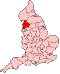
| Regio | North West England | ||
| Coördinaten | 53°54'0"NB, 2°48'32"WL | ||
| Algemeen | |||
| Oppervlakte | 282,1476[1] km² | ||
| Inwoners (2018[2]) | 111.223 (394 inw./km²) | ||
| ONS-code | E07000128 | ||
| Detailkaart | |||
 | |||
| Foto's | |||
 | |||
| Kerk van Sint Hilda in Bilsborrow | |||
| |||

Wyre is een Engels district in het shire-graafschap (non-metropolitan county OF county) Lancashire en telt 111.000 inwoners. De oppervlakte bedraagt 282 km².
Van de bevolking is 22,2% ouder dan 65 jaar. De werkloosheid bedraagt 2,5% van de beroepsbevolking (cijfers volkstelling 2001).
Plaatsen in district Wyre
- Poulton-le-Fylde
- Thornton Cleveleys
Civil parishes in district Wyre
Barnacre-with-Bonds, Bleasdale, Cabus, Catterall, Claughton, Fleetwood, Forton, Garstang, Great Eccleston, Hambleton, Inskip-with-Sowerby, Kirkland, Myerscough and Bilsborrow, Nateby, Nether Wyresdale, Out Rawcliffe, Pilling, Preesall, Stalmine-with-Staynall, Upper Rawcliffe-with-Tarnacre, Winmarleigh.
Bronnen, noten en/of referenties
- ↑ Office for National Statistics → Download → SAM_for_Administrative_Areas_(2018).zip → SAM_LAD_DEC_2018_UK.xlsx.
- ↑ https://www.ons.gov.uk/file?uri=/peoplepopulationandcommunity/populationandmigration/populationestimates/datasets/populationestimatesforukenglandandwalesscotlandandnorthernireland/mid20182019laboundaries/ukmidyearestimates20182019ladcodes.xls Schatting Office for National Statistics: knop MYE5 → kolom Estimated Population mid-2018]
- Volkstelling 2001, Office for National Statistics
Mediabestanden
Zie de categorie Borough of Wyre van Wikimedia Commons voor mediabestanden over dit onderwerp.
Geplaatst op:
18-02-2006
18-02-2006
Dit artikel is een beginnetje over landen & volken. U wordt uitgenodigd om op bewerken te klikken om uw kennis aan dit artikel toe te voegen.


