Lower Klamath National Wildlife Refuge
Wildlife refuge and National Historic Landmark in northern California, United States
41°56′56″N 121°41′48″W / 41.9487624°N 121.6966630°W / 41.9487624; -121.6966630[1]
U.S. National Historic Landmark
The Lower Klamath National Wildlife Refuge is a National Wildlife Refuge of the United States on the border between California and Oregon. It is operated by the United States Fish and Wildlife Service. The refuge was designated a National Historic Landmark on October 16, 1965.[3]
Lower Klamath National Wildlife Refuge, established by President Theodore Roosevelt in 1908, was the first waterfowl refuge in the United States. It is located in the Klamath Basin near Klamath Falls, Oregon. It has a total area of 50,912.68 acres (206.04 km2), of which 44,294.55 acres (179.25 km2) are in California and 6,618.13 acres (26.78 km2) are in Oregon.[2] The refuge includes shallow freshwater marshes, open water, grassy uplands, and croplands that are intensively managed to provide foraging and breeding habitat for waterfowl and other animals. The market hunting of migratory birds in the late 19th century created the need for preservation and creation of a wildlife refuge.[4]
Refuge objectives include the protection of habitat for flora and fauna, including migrating waterfowl, and preserving the biodiversity of the Klamath Basin. It works to integrate wetlands and sustainable agriculture and promote integrated pest management. The refuge provides wildlife-related public services, including education, hunting, and viewing and photography opportunities.
Avian species on the refuge include the bald eagle, golden eagle, American white pelican, white-faced ibis, snow goose, Ross's goose, greater white-fronted goose, Canada goose, peregrine falcon, northern pintail, mallard, gadwall, canvasback, western grebe, eared grebe, black tern, and tricolored blackbird.
Conservation and management activities include the maintenance of a local water infrastructure and the monitoring of the interaction between agriculture and habitat. Issues in focus include the loss of wetland habitat, the degradation of water quality, drought, and water rights.
Gallery
-
 Ross's geese on a freshwater marsh
 -
 Mountains
 -
 Marsh with American coots
 -
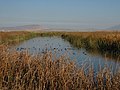
 Lower Klamath Lake marsh


See also
- List of largest National Wildlife Refuges
- List of National Wildlife Refuges
- Volcanic Legacy Scenic Byway
References
Wikimedia Commons has media related to Lower Klamath National Wildlife Refuge.
![]() This article incorporates public domain material from websites or documents of the United States Fish and Wildlife Service.
This article incorporates public domain material from websites or documents of the United States Fish and Wildlife Service.
- ^ "Lower Klamath National Wildlife Refuge". Geographic Names Information System. United States Geological Survey, United States Department of the Interior. Retrieved August 21, 2011.
- ^ a b "Annual Report of Lands as of September 30, 2009" (PDF). United States Fish and Wildlife Service.
- ^ a b c "Lower Klamath National Wildlife Refuge". National Historic Landmark summary listing. National Park Service. Archived from the original on November 14, 2007. Retrieved July 5, 2008.
- ^ Huston, Anne E.; Huston, Anne E. (1999). a River Never the Same. Klamath Falls, OR: Shaw Historical Library. pp. 59–60. ISBN 0-9667919-1-6.
External links
- "Lower Klamath National Wildlife Refuge". U.S. Fish and Wildlife Service.
- v
- t
- e
- List of U.S. National Historic Landmarks by state:
- Alabama
- Alaska
- Arizona
- Arkansas
- California
- Colorado
- Connecticut
- Delaware
- Florida
- Georgia
- Hawaii
- Idaho
- Illinois
- Indiana
- Iowa
- Kansas
- Kentucky
- Louisiana
- Maine
- Maryland
- Massachusetts
- Michigan
- Minnesota
- Mississippi
- Missouri
- Montana
- Nebraska
- Nevada
- New Hampshire
- New Jersey
- New Mexico
- New York
- North Carolina
- North Dakota
- Ohio
- Oklahoma
- Oregon
- Pennsylvania
- Rhode Island
- South Carolina
- South Dakota
- Tennessee
- Texas
- Utah
- Vermont
- Virginia
- Washington
- West Virginia
- Wisconsin
- Wyoming
 National Register of Historic Places portal
 Category


Authority control databases | |
|---|---|
| International |
|
| National |
|


