Salt Point State Marine Conservation Area
Marine protected area in California
| Salt Point State Marine Conservation Area | |
|---|---|
| Location | California |
| Governing body | California Department of Fish and Wildlife |
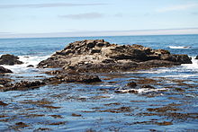
Salt Point State Marine Conservation Area (SMCA) is a marine protected area that lies onshore from Fisk Mill Cove and south along Salt Point State Park in Sonoma County on California's north central coast. The marine protected area covers 3.12 square miles (8.1 km2). Salt Point SMCA prohibits the take of all living marine resources, except the recreational take of abalone and finfish.
History
Salt Point SMCA is one of 22 marine protected areas adopted by the California Department of Fish and Game in August 2009, during the second phase of the Marine Life Protection Act Initiative. The MLPAI is a collaborative public process to create a statewide network of protected areas along California's coastline.
The north central coast's new marine protected areas were designed by local divers, fishermen, conservationists and scientists who comprised the North Central Coast Regional Stakeholder Group. Their job was to design a network of protected areas that would preserve sensitive sea life and habitats while enhancing recreation, study and education opportunities.
The north central coast marine protected areas took effect May 1, 2010.
Geography and natural features
Salt Point SMCA is a marine protected area that lies onshore from Fisk Mill Cove and south along Salt Point State Park in Sonoma County on California's north central coast. Salt Point SMCA adjoins Stewarts Point State Marine Reserve at its southern boundary.
Salt Point SMCA is bounded by the mean high tide line and straight lines connecting the following points in the order listed:
- 38°35.6′N 123°20.8′W / 38.5933°N 123.3467°W / 38.5933; -123.3467
- 38°35.6′N 123°21.0′W / 38.5933°N 123.3500°W / 38.5933; -123.3500
- 38°33.5′N 123°21.0′W / 38.5583°N 123.3500°W / 38.5583; -123.3500 and
- 38°33.5′N 123°18.91′W / 38.5583°N 123.31517°W / 38.5583; -123.31517, except that Gerstle Cove is excluded.
Habitat and wildlife
Salt Point SMCA protects a complex rocky habitat which includes coves, kelp, wash rocks, shelves, walls, cobble and boulders as well as associated species like red abalone, red urchin and rockfish. Bull kelp thrives along this area and can grow up to ten inches per day as it reaches for sunlight at the ocean's surface.
The SMCA provides continuous land-sea protection and management in waters adjacent to Salt Point State Park, protecting diverse habitats in a highly scenic and relatively remote area for both consumptive and non-consumptive recreational purposes.
Recreation and nearby attractions
Nearby Salt Point State Park features six miles of rugged coastline, free diving and SCUBA diving, 20 miles of hiking trails, pygmy forests, horseback riding and two campgrounds. Fisk Mill Cove is a day use area that offers stunning ocean views from Sentinel Rock and provides visitors with paved parking, picnic tables, small upright barbecues, restrooms, and drinking water. Stump Beach is another picnic area that also offers one of the few sandy beaches north of Jenner. Kruse Rhododendron State Natural Reserve adjoins Salt Point State Park and features hiking trails through pristine forests of Douglas fir, tanoak, grand fir and rhododendrons.
Of historical interest is nearby Fort Ross State Historic Park, the southernmost settlement in the Russian colonization of the North American continent that was established as an agricultural base to supply Alaska. It was the site of California's first windmills and shipbuilding, and Russian scientists were among the first to record California's cultural and natural history.
Salt Point SMCA prohibits the take of all living marine resources, except the recreational take of abalone and finfish. However, California's marine protected areas encourage recreational and educational uses of the ocean.[1] Activities such as kayaking, diving, snorkeling, and swimming are allowed unless otherwise restricted.
Scientific monitoring
As specified by the Marine Life Protection Act, select marine protected areas along California's central coast are being monitored by scientists to track their effectiveness and learn more about ocean health. Similar studies in marine protected areas located off of the Santa Barbara Channel Islands have already detected gradual improvements in fish size and number.[2]
References
- ^ Department of Fish and Game. "California Fish and Game Code section 2853 (b)(3) Archived 2013-03-26 at the Wayback Machine". Marine Life Protection Act. Retrieved December 18, 2008.
- ^ Castell, Jenn, et al. "How do patterns of abundance and size structure differ between fished and unfished waters in the Channel Islands? Results from SCUBA surveys". Partnership for Interdisciplinary Studies of Coastal Oceans (PISCO) at University of California, Santa Barbara and University of California, Santa Cruz; Channel Islands National Park. Retrieved December 18, 2008.
External links
 San Francisco Bay Area portal

- Salt Point State Park
- v
- t
- e
National Park System | |||||||||||||||||
|---|---|---|---|---|---|---|---|---|---|---|---|---|---|---|---|---|---|
| |||||||||||||||||
National Forests and Grasslands | |||||||
|---|---|---|---|---|---|---|---|
| |||||||
|
| |||||||
| |||||||
|
|
- Heritage registers
- National Natural Landmarks


